Summer 2005
Summer 2005 |
|||||||
|
|
|||||||
Emergency Response Planning and Integrating ALOHA Plume Models
Genesee County, New York, Emergency Management Services Uses GIS |
|||||
|
In the past, all emergency response planning involved tedious and manual work processes. EMS staff realized that a more efficient process was needed to help in analyzing, preparing, and reporting for emergency response scenarios. More important, the county realized a tremendous need to better manage the county's sensitive assets and resources, develop more precise response plans for disaster and weapons of mass destruction scenarios, share critical data with other county departments, and provide the analytical information required in a timely fashion for all Genesee County emergency response staff. Emergency Management Responsibilities
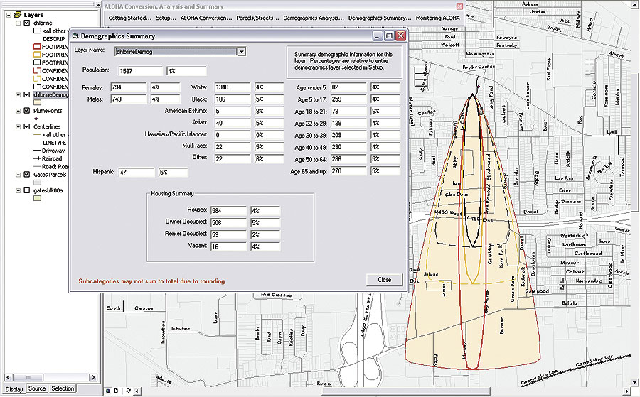
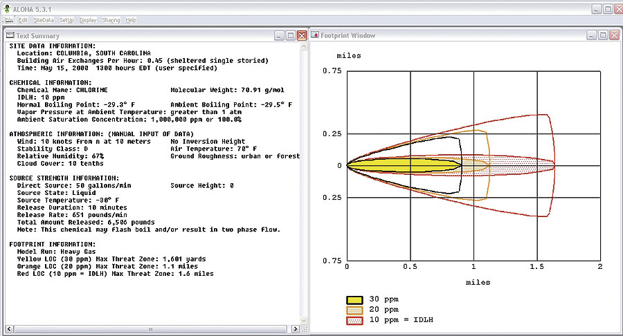
The Genesee County Emergency Management Office's responsibilities are centered around assessing, analyzing, managing, and protecting Genesee County's population through emergency planning and coordination of emergency services operations in major emergencies and disasters. The office provides on-scene assistance to fire, emergency medical, law enforcement, and public officials during emergency situations and in local planning efforts. Emergency planning activities also include the protection of many valuable assets and resources within the county. The Emergency Management Office plans for a wide variety of emergency considerations. These include fixed site chemical and radiological emergencies; transportation incidents; and the location and protection of public water supply systems, sewer systems, communications, highway infrastructure, and emergency response operations. Planning for the protection of public assets and emergency operations has become more important since the events of September 11, 2001. "We were in need of a more comprehensive tool that would allow for a more precise level of detail and analysis when looking at a variety of emergency situations," says Keith Hunt, deputy coordinator, Genesee County Emergency Management Services. "We had access to a number of GIS data sets but no way to integrate them into a convenient, visual analytical reference." Homeland Security Grant and Project Start-UpThe Genesee County EMS staff quickly recognized the need for using GIS as part of their daily operations. The EMS staff applied for and successfully received the Esri Homeland Security Grant for Critical Infrastructure in November 2002. As part of this grant, Genesee County EMS received ArcView and ArcPad software, data, and training. The results of this project kickoff started the EMS staff's vision for putting GIS into high gear. Now that the pieces were in place to start using GIS effectively, a plan was developed for EMS staff to start collecting GIS data, analyzing it, and incorporating the results into the required formats and reports. One of the key challenges that Genesee County EMS staff faced was analyzing and reporting on potential impacts to residences, assets, and sensitive areas for the 16 chemical storage facilities within the county. The county EMS staff members utilized the Environmental Protection Agency's Areal Locations of Hazardous Atmospheres (ALOHA) plume modeling software to determine the extent of plumes for each of the sites but were unable to integrate this plume data into GIS for analytical and reporting purposes. Genesee County's GIS contractor, Esri Business Partner Bergmann Associates (Rochester, New York), developed a software solution called ALOHA Conversion and Analysis Summary (ACAS) that would automatically integrate the ALOHA plume models directly into ArcView to analyze parcels, demographics, and other assets within the county.
Using ACAS, the county was able to automate the linkage between ALOHA software and ArcView and seamlessly integrate plume models into GIS. This integration included monitoring the ALOHA software for new plume models being generated, reporting the number of parcels and residents within each plume footprint or confidence interval, and creating graphic and tabular reports within ArcView and Crystal Reports for EMS staff to take into the field for verification. In addition, EMS staff members were now able to generate lists of all known chemical storage facilities, efficiently create detailed emergency response plans, and produce detailed maps for each facility outlining plume models and impacted areas. ResultsThe Genesee County Emergency Management Office is now able to better manage and implement its Homeland Security Plan, specifically the Weapons of Mass Destruction and Terrorist Plans. The data and ALOHA integration application developed as part of this project have allowed the emergency management staff to better manage the department's data and develop precise contingency plans for terrorist threats. EMS staff members are now able to share this valuable information with other departments and provide valuable assistance and data analysis for the county's emergency and terrorism response plans and committees. These include the Countywide Comprehensive Emergency Management Plan, Hazardous Materials Response Plan, Law Enforcement Threat Group, Vulnerability and Capability Needs Assessment Group, Public Health Emergency Preparedness Assessment, and Hospital Task Force. The Law Enforcement Threat Group, Vulnerability and Capability Needs Assessment Group, Public Health Emergency Preparedness Assessment Group, and Hospital Task Force were all established in response to the events of September 11, 2001, for the purpose of weapons of mass destruction/terrorist planning. Hunt explains, "The most important benefit from using GIS software in homeland security and emergency planning projects is better managed data and a variety of analysis tools useful in both on-scene mitigation efforts and comprehensive emergency planning projects." For more information, contact Keith Hunt, deputy coordinator, Genesee County Emergency Management Services (tel.: 585-344-0078, e-mail: khunt@co.genesee.ny.us), or Jeff Volpe, Bergmann Associates (tel.: 800-724-1168, ext. 282; e-mail: jvolpe@bergmannpc.com). |
 Located between the cities of Buffalo and Rochester, New York, Genesee County is a small, steadily growing rural county with a population of roughly 62,000 citizens. Like many other counties and municipalities, the county has valuable assets, hazardous material storage locations, and environmentally sensitive areas that if harmed or destroyed would have a severe impact on the residents within the county. Genesee County Emergency Management Services (EMS) staff spent many hours and resources in developing emergency response planning activities, including preplans, evacuation routes, and damage assessment reports, for scenarios involving the sensitive locations and chemical storage facilities within the county.