Summer 2005
Summer 2005 |
|||||||
|
|
|||||||
In Puerto Rico, University Infrastructure, Sustainable Natural Resources Are Managed with GIS |
|||
|
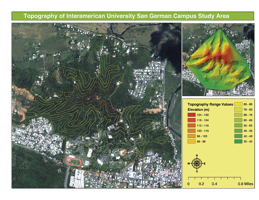
The Interamerican University of Puerto Rico, San Germ�n Campus, is known as a university paradise. This is because of all the major institutions of higher education in Puerto Rico, this one has the most natural resources on its campus. The campus comprises an area of 254 acres (102.8 hectares) and is located in the municipality of San Germ�n in southwestern Puerto Rico. Historically the area was used to cultivate sugarcane so all the native vegetation has been removed except for the low elevation hills in the middle of the valley. This area is situated in the alluvial valley of the Guanajibo River. The university's campus is situated on these hills, and the vegetation is a very important transition zone for the species of animals and plants in this area.
The Geographic Information Systems and Environmental Research Laboratory (GISERL) of the Interamerican University San Germ�n Campus developed a project using GIS to provide a comprehensive overview of the infrastructure resources (buildings, roads, facilities, etc.) of the campus and their importance in conservation. This project was essential because it provided the campus administration with a geographic distribution of the resources of this forested area. In addition, since the university is in the middle of the town's historic, main downtown area and urban development has sprawled around the campus, the project provided the university's administration with important information about conservation of this area. Following a study of the available applications, ArcGIS (ArcEditor) software was selected for development of this project. The project began by establishing the property limits of the campus. This information was obtained from the 1966 Land Survey Map of the Interamerican University San Germ�n Campus property. All points from this map were entered in ArcEditor software's ArcMap application as x,y data. For this task, GISERL used ArcMap to digitize and georeference the Land Survey Map of the campus based on IKONOS image (2002) data and obtained geographic coordinates from the field to adjust the boundaries of the polygon to the other neighboring cadastral units. Once the property points were fixed, GISERL created a polygon using tools from ArcEditor. The Land Survey Map showed that the campus comprised 254 acres; using the XTools extension, the team calculated the area of the polygon to be exactly 254 acres. Then, GISERL used ArcEditor software's ArcMap application to digitize the entire infrastructure of the university from the IKONOS image (2002) and then adjusted the polygons that were created using geographic points obtained from the field (Garmin 76S GPS Unit), especially when the structure or building was blocked from view by tree canopies. There were 74 structures identified on the campus, and basic information about height of the buildings, names, and location was incorporated in the shapefile. Pictures of these structures were taken and incorporated in the attributes table to be accessed by hyperlinks. All roads within the campus were obtained by GPS tracks in the field and then incorporated into ArcEditor where they were labeled and their distances calculated using the XTools extension. Land-use information was obtained from the USGS Land Use San Germ�n Quadrangles (1977), and a clip was made of the campus polygon using the geoprocessing wizard in ArcEditor. This clip was then modified and edited to adjust the changes from the 1977 USGS map to the IKONOS image (2002) and the zoning map of the San Germ�n municipality. This correction showed that of the total area of 254 acres that comprises the campus, 36 percent (91.4 acres) is being used extensively by the institution. The remaining 64 percent (162.6 acres) is high-density/low-density woodland. Using the ArcGIS 3D Analyst extension, a TIN was created from the topographic contour shapefile of the San Germ�n Topographic Quadrangle. This TIN was used to provide a visualization of the campus in the hills within the alluvial valley and to obtain the slope of the study area. The IKONOS image (2002) was attached to the TIN base heights to aid in the visualization of the study area. This project was presented to the campus chancellor, dean of Administration and Academic Affairs, and other administration and faculty members. GISERL used the 3D visualization provided by ArcGIS 3D Analyst software's ArcScene and created a movie clip of the campus to build interest in the administration. The campus administration approved the use of this technology, and now efforts are being made to include a geographic database of all the buildings' development and maintenance plans in the project. For more information, contact William Joel Hernandez, GIS analyst, GISERL (tel.: 787-409-0260, e-mail: whernandez@sg.inter.edu). |