Summer 2005
Summer 2005 |
|||||||
|
|
|||||||
Singapore Agency Chooses GIS for Enterprise Mapping
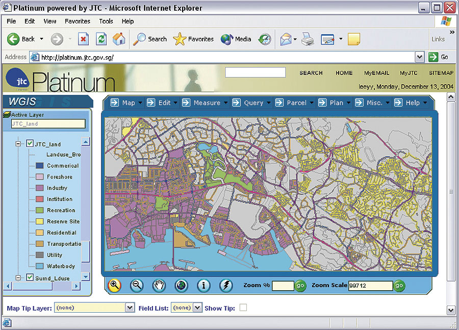
JTC Corporation Fine-Tunes Retrieval and Query of Spatial Information |
|||
|
JTC Corporation is a leading agency in Singapore in planning, promoting, and developing high-quality industrial facilities and industrial space. Over the past three decades, JTC has developed 7,000 hectares of land for industrial uses and more than four million square meters of ready-built industrial space for approximately 7,000 local and multinational companies. Among these are specialized parks and facilities for high-technology and biomedical industries.
JTC's Land Planning Group plans industrial space, propagates the work-live-play-learn concept in industrial parks, develops conceptual master plans, and manages JTC's land resources. The various development groups prepare, develop, and market JTC's industrial properties (i.e., land and ready-built facilities). In the past, JTC planners had to prepare the graphical data and run a batch program to convert data from CAD to GIS format. The conversions took a few days and exhausted resources considerably. In addition, JTC's marketing officers were unable to retrieve multistory building information due to the limitations of the old system, relying heavily on consultants for each plan generation with one to three days of response time. This lowered efficiency of the overall operations of the groups. JTC's latest project, Web-based GIS (WGIS), is helping JTC retrieve and query spatial information on multistory buildings, something that the old system was unable to do. JTC can generate allocation, site, and location plans and integrate them with its new eCREAM system for textual information using WGIS. GIS was chosen because it can integrate spatial and textual information needed for land planning and marketing purposes. In addition to generating plans, WGIS will perform basic map operations, query textual and spatial information, and perform thematic mapping. Developed by Satyam Computer Services, JTC's WGIS uses ArcInfo, ArcEditor, ArcGIS Server, and ArcSDE licenses because this combination of software creates seamless integration with JTC's other applications. Users are able to access information from other applications through a single gateway. There is also a powerful query tool to retrieve textual and spatial information on JTC's industrial properties for decision making and planning analysis. WGIS now provides the advantages of using maps for decision support. With easy-to-use Web browsers, WGIS provides a much more dynamic tool than a static map display. It delivers interactive query capabilities to improve overall efficiency for site visits and negotiations, such as
All of the geospatial data were Web enabled with ArcGIS Server and ArcSDE. WGIS helps users locate property by defining a query or graphically drawing a rectangle on a map. The user can also locate the property by buffering around known features, such as bus stops, roads, or rail networks. WGIS allows JTC planners to edit, store, and perform map digitizing of key data layers, including infrastructure and services information and corporate graphic, planning, survey, and engineering information, in a centralized WGIS database. WGIS is based on an n-tier architecture with external and internal interfaces interacting with the main subsystem. The presentation tier is responsible for creating dynamic views and manages user authentication and validation. The business logic tier manages the logic of the application and interacts with the enterprise information system. The enterprise information system is responsible for managing the spatial and attribute data and maintaining versions. This tier uses ArcSDE as the efficient storage tool, which would be installed on the Microsoft SQL Server database. ArcSDE provides tools to manipulate and store the data as versioned for different levels of users. For more information, contact Tan Soo Cheow, Customer Applications Unit, JTC (e-mail: soocheow@jtc.gov.sg, Web: www.jtc.gov.sg). |