Summer 2005
Summer 2005 |
|||||||
|
|
|||||||
Municipal GIS Brings New Capabilities to Ukraine |
|||
|
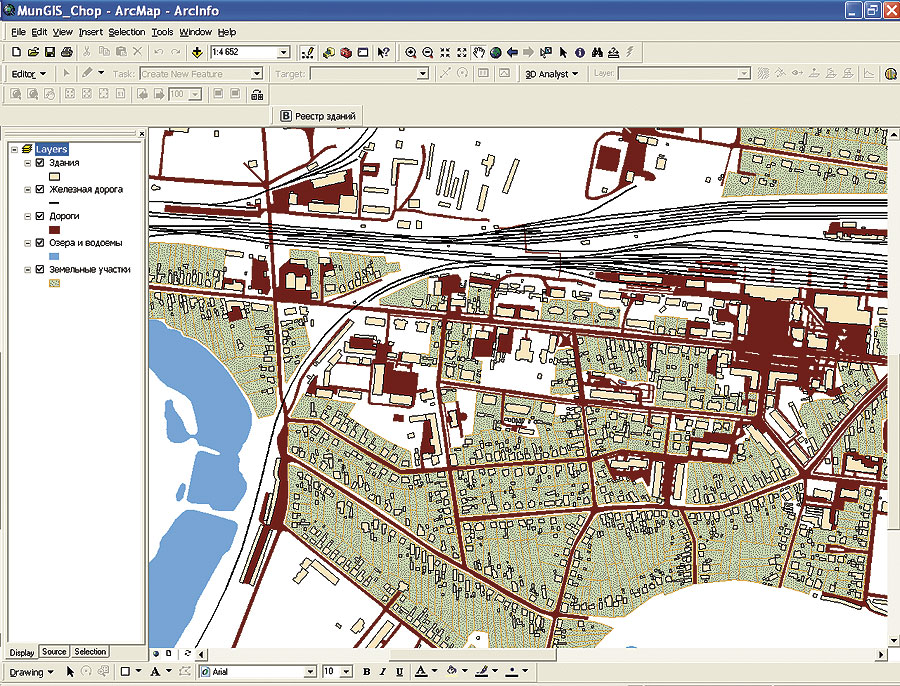
By David Schaub, Altarum Institute, Ann Arbor, Michigan, and Paul Hearn, U.S. Geological Survey, Reston, Virginia Geographic information systems are virtually ubiquitous among local governments in the United States where they are used for tracking information related to land parcels, zoning, infrastructure, hazard mitigation, and other applications. Such systems are comparatively rare, however, in countries of the former Soviet Union, where information is commonly stored on maps or in hard-copy files. Drawing on experience gained from establishing municipal GIS systems in Central America following the Hurricane Mitch disaster (see mitchnts1.cr.usgs.gov), the U.S. Geological Survey (USGS) designed and implemented an effort to bring these capabilities to two towns in the Trans-Carpathian region of western Ukraine. The Need
Trans-Carpathia, or "Zakarpattia," is a mountainous area that drains into the Tisa River basin, a watershed shared with Romania, Hungary, and Slovakia. This region experienced severe flooding in 1998 and again in 2001 due to a combination of heavy rains and rapidly melting snow. With funding provided by the U.S. Agency for International Development (USAID), during the past three years USGS has installed several flood-warning stream gauges in this area. As part of this program, USGS also provided complete GIS systems and arranged for Esri training for municipal staff in the towns of Chop and Svalyava. The project was implemented jointly with the Ukrainian Land and Resource Management Center (ULRMC) in Kyiv and Altarum Institute, a U.S. nonprofit research organization in Michigan. The goal was to demonstrate to local governments how modern geospatial technology could help mitigate the risk of future flooding and allow them to perform various administrative tasks more accurately and efficiently. GIS and Training Provided to StaffThe GIS provided to each town consisted of a high-end desktop computer, ArcView software, digital camera, GPS unit, and basemapping data. Esri was chosen as the preferred GIS software provider for several reasons. First, there is a substantial user base already present in Ukraine that uses Esri products for high-end GIS tasks; this facilitates data sharing among government entities. Second, there is in-country product support through ECOMM, the Esri distributor in Ukraine. Third, ULRMC, the local implementer of the project, possessed much experience with database development and application programming in the Esri product environment. User training was performed jointly by ULRMC and ECOMM, which are both in Kyiv, in each of the respective communities. ULRMC also developed custom interfaces, which streamlined the process of data entry and searching. During training, municipal staff members were instructed in the basic concepts of GIS, how to use the software, and how to load their data into their GIS systems. Users in Chop had an advantage in learning the new software because of their prior experience with using a digital cadastre system. Early ResultsSince the two communities have different skill levels and priorities, the two systems are being used for different purposes. At the moment, Chop is focusing on digitizing its parcel data, while in Svalyava the emphasis is on assembling base data for roads, buildings, and other infrastructure. Both communities intend to add layers as resources permit. Once the data layers are fully populated, city officials see many practical uses for ArcView, such as delineating voting districts based on population distribution, optimizing routes for garbage collection and snow removal, managing electric utilities, and ensuring that local taxes are collected fairly. Another goal is to analyze environmental information that will help city administrators improve water supplies and public safety. ArcView will also be helpful in identifying areas of flood and landslide risks and for determining optimal evacuation routes. The mayors of Chop and Svalyava have been strong advocates of the new systems, demonstrating their capabilities to other local officials within Trans-Carpathia. Upon seeing the system in Svalyava, a visiting delegation of officials from Slovakia expressed surprise that such capabilities existed within Ukraine and commented that the systems were superior to their own. Mayor I.I. Revtiy of Svalyava also created a presentation describing the town's new resources, which he delivers to local schoolchildren to spark their interest in information technology and environmental issues in the community. While limited in scope, the municipal GIS project is generating interest among local officials in western Ukraine and in neighboring countries. The systems are adaptable to the specific needs of each community and should improve city services. In general, the populace is more receptive to visible improvements in the infrastructure of their communities, such as new roads or bridges. Consequently, both mayors face a public relations challenge in communicating the somewhat less visible benefits of GIS technology for city administration. ULRMC provides a full range of GIS and remote-sensing services for the Ukrainian government, private business, and Western clients. ULRMC began in 1999 as a joint project between Altarum Institute (formerly the Environmental Research Institute of Michigan) and the Environmental Resource Research Institute of Ukraine and has received extensive funding support from USAID. For more information about ULRMC, visit www.ulrmc.org.ua or contact Dr. Oleksandr Kolodyazhnyy (e-mail: o.kolodyazhnyy@ulrmc.org.ua). For more information about USGS activities in Ukraine, contact Dr. Paul Hearn (e-mail: phearn@usgs.gov). |