Summer 2005
Summer 2005 |
|||||||
|
|
|||||||
Regional Bird Conservation Internet Mapping Tool Takes Flight with GIS |
||||||||
|
By John C. Nelson, Timothy J. Fox, Melinda G. Knutson, John R. Sauer, and Wayne E. Thogmartin, USGS
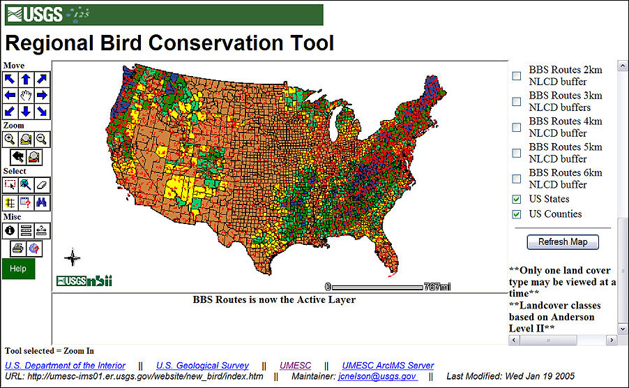
Imagine having 30 years of bird data selected from anywhere in the continental United States analyzed in seconds by experts in bird biology, and you do not need an expense account or advanced degree in GIS technology or statistics! Is this a biologist's dream, or is it real? How many bird enthusiasts planning their next vacation know they can generate their own bird species checklist for their vacation destination from this same dataset? The dream became reality when the United States Geological Survey (USGS) developed an Internet mapping site to give natural resource managers and the general public access to an extensive federal breeding bird dataset. The USGS Breeding Bird Survey (BBS) has archived observations of birds sighted by volunteers along roadsides since 1968. BBS uses standard protocols to collect, archive, and analyze the data. USGS has long made the raw data and some summary analyses available on the Internet. The new Internet site, termed the Regional Bird Conservation Tool (RBCT) (umesc-ims01.er.usgs.gov/website/new_bird, may be down temporarily for server maintenance), allows users to select specific routes graphically on a map and quickly obtain both habitat and bird information for that location. Also, the user can graphically select a route and link to existing bird population trend estimates, along with state and regional summaries, in a single work session. The USGS National Biological Information Infrastructure, Bird Conservation Node (birdcon.nbii.gov) is the Internet gateway to both the raw BBS data and RBCT. Several factors led BBS to use ArcIMS for distributing breeding bird data. In many instances, the users have neither been trained in GIS nor do they have adequate software or hardware. Additionally, BBS wanted the tool to be dynamic. Using ArcIMS as the delivery mechanism, BBS is able to update databases and spatial coverages without the need to export the datasets to users and partners. Reaching a large audience was important, and using ArcIMS made this possible.
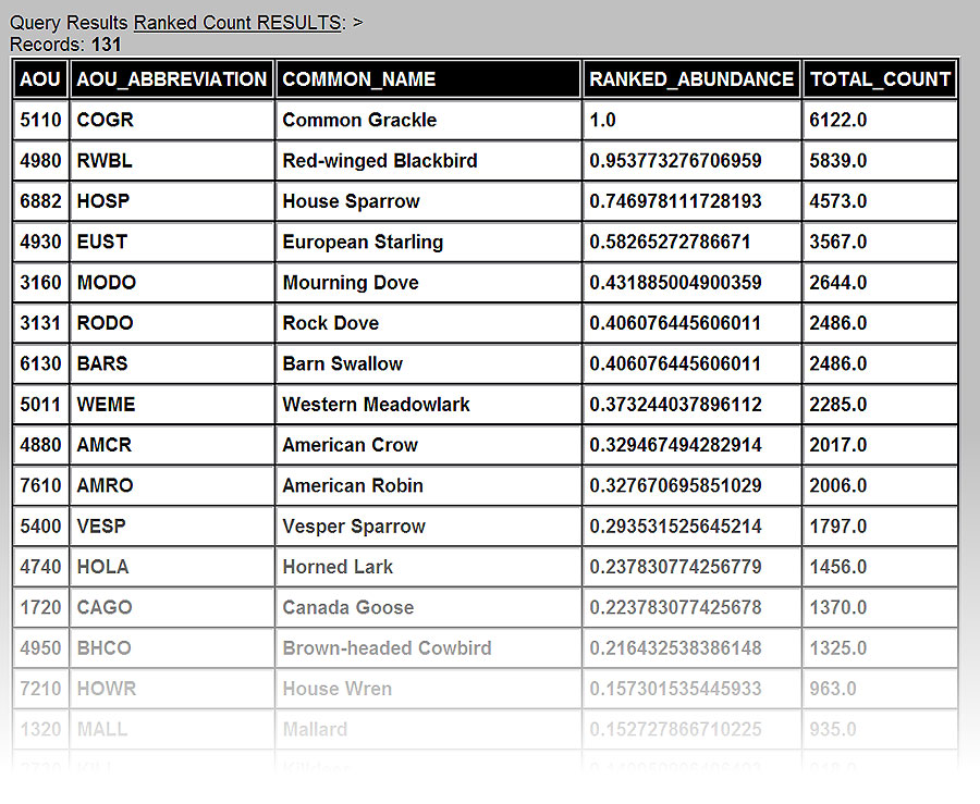
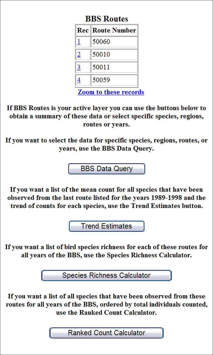
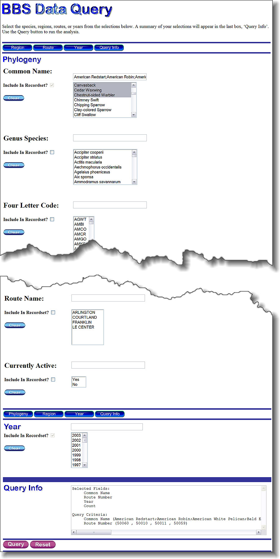
RBCT allows the user to visualize land uses and summarize bird counts collected by BBS for areas such as federal and tribal lands, counties, states, and other geographic divisions. Users can select a specific location and calculate the number of bird species observed on BBS routes adjacent to that location. For example, users can obtain information on the amount of forest within a county and find the number of golden-winged warblers (Vermivora chrysoptera) counted by BBS within or near that county over the last 30 years. This information is important to biologists seeking to conserve birds and their habitats. At the heart of RBCT is a ColdFusion connection from ArcIMS to the raw tabular BBS data (www.pwrc.usgs.gov/bbs). Using BBS routes selected in ArcIMS, a ColdFusion-driven Web page allows users to query the extensive BBS dataset. RBCT also allows users to perform additional calculations. A comprehensive list of all species ever identified by BBS on the selected routes, ranked by count, can be generated. Not only is the list useful for resource managers, but amateur bird-watchers can also use this list as a birding checklist. A species-richness formula was also added to the site, which allows users to get the cumulative number of all bird species identified on the selected routes. Species richness is a useful measurement for conservationists because it is a simple means for describing biodiversity. Bird populations change over time, and one of the big benefits of a long-term dataset, such as BBS, is that population trends can be calculated with some confidence. Population trends are highly valued measurements for conservation biologists because persistent population declines portend a species headed for trouble. RBCT also allows the user to select a single BBS route and see the population trend estimates, along with a graph for each species. State and regional summaries of population trend estimates are also available.
Resource managers are often interested in the habitat along BBS routes and how that habitat is used by birds. Biologists can use this data to better understand bird distributions and to estimate bird populations. A large federal dataset of land cover is available—the USGS National Land-Cover Dataset. Land-cover composition summaries of 1-10 km buffers of the BBS routes, U.S. counties, and federal and tribal lands for the continental United States were all completed using an ArcView Avenue script written by USGS. This summary information is available to users of RBCT. RBCT makes available spatially explicit summaries of two large U.S. federal spatial datasets (birds and land cover) to anyone interested in exploring them. Conservationists, bird-watchers, and natural resource managers (and, of course, the birds) are expected to reap the benefits. For more information, contact John C. Nelson, Upper Midwest Environmental Sciences Center, USGS, La Crosse, Wisconsin (tel.: 608-781-6370, e-mail: jcnelson@usgs.gov).
|