Summer 2005
Summer 2005 |
|||||||
|
|
|||||||
Established by the U.S. Library of Congress, Geography and Map Division
The Congressional Cartography Program Responds to United States Senate and House of Representatives with GIS |
|||||||||
In recent years, awareness and use of GIS within the United States Senate and House of Representatives has been limited to only a few congressional offices, with limited coordination between them. There hasn't been a one-stop GIS shop where congressional offices could obtain geographic information and services to make better informed policy decisions—until now. Housed in the Library of Congress, Geography and Map Division, the Congressional Cartography Program (CCP) was established in summer 2003 to provide congress with on-request cartographic products and services. The Library of Congress has been collecting cartographic materials since its beginning in 1800. Today, the Geography and Map Division's holdings number more than five million maps, charts, atlases, globes, models, and digital files, occupying a 2.5-acre space in the James Madison building in Washington, D.C. It is the largest and most comprehensive cartographic collection in the world. And now CCP provides a new realm of services for congress, using GIS software that provides dynamic, custom-made products.
The long-range mission of CCP is to perform the essential data acquisition and integration and cartographic design to develop customized applications for members and committees of congress and the Congressional Research Service—the public policy research arm of congress. Initially, CCP has been focusing on the development of a few basic cartographic products, but will ultimately develop into a multistaff geographic analysis program and one-stop decision support system. This system will be able to provide easy-to-use applications for basic reference mapping production and a backdrop for more sophisticated geographic analysis. Having a streamlined production application in place allows CCP staff members to focus their efforts on in-depth analysis, custom cartography (which may include an international scope), consulting, training, and geographic outreach. Robert Dizard, Library of Congress deputy associate librarian of library services, states, "The Congressional Cartography Program allows us to meet the library's first priority of service to congress by providing an insightful new way for members and staff to analyze public policy issues and develop legislative proposals. CCP also helps keep the Geography and Map Division's collections current and useful to researchers, scholars, and other library users and assists the division in documenting the historical development and use of GIS data." There is also a great opportunity for CCP to promote geography as a curriculum to schools and the general public. CCP's direct service to congress brings awareness to the important value of a geographic education. Staffers, members, and committees of congress can attest to the significance of education through geographic awareness and the applied use of GIS. CCP not only provides an ample opportunity for the Library of Congress to offer a dynamic service to congress, but it also gives academia and industry the chance to promote GIS technology and geographic education as a whole. High-quality cartographic maps are currently CCP's most requested product. Ginny Mason, cartographer for the CCP, uses ArcInfo for most of the incoming requests and has pushed the software to its full cartographic capabilities. However, the services that CCP provides go far beyond offering a nice-looking map.
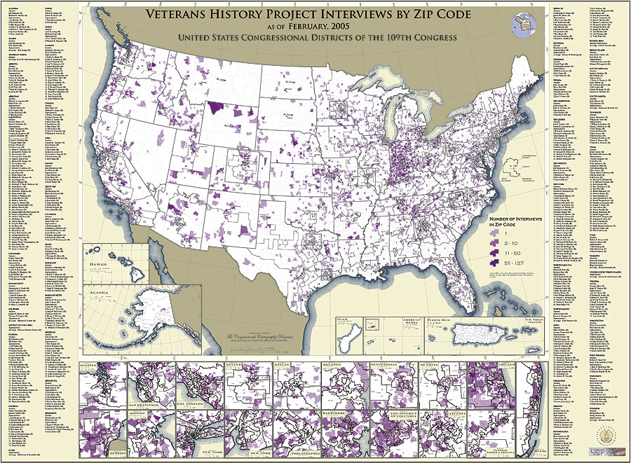
Says Mason, "The idea is to integrate good cartographic design with GIS analysis to make maps—and to improve the processes involved in making maps, which result in effective tools for decision making." Cartographic production involves two stages: (1) the basemap with which the analyst starts the analysis and (2) the final presentation—of the results of the analysis. Geographic services provided by CCP aid in the performance of the intermediate stage-the actual analysis. To serve congress in a timely and efficient manner, CCP has created a map template approach to cartographic production that allows efficient production of frequently requested core cartographic products. The templates provide customers with products that allow quick turnover for frequently requested geographical extents, such as maps of congressional districts and individual states, so they can devote more staff time to complex analysis and geographic services. CCP is developing a cartographic design standard to optimize end-use needs and provide a trademark product distinctive of the Library of Congress. Beginning with maps of congressional districts and individual states, CCP will then move on to other extents, such as maps of counties, individual countries of the world, U.S. ZIP Codes, and thematic distributions of various data at a national scale. In developing these basemap products, CCP is creating a cartographic geodatabase model within ArcInfo, thus streamlining cartographic production.
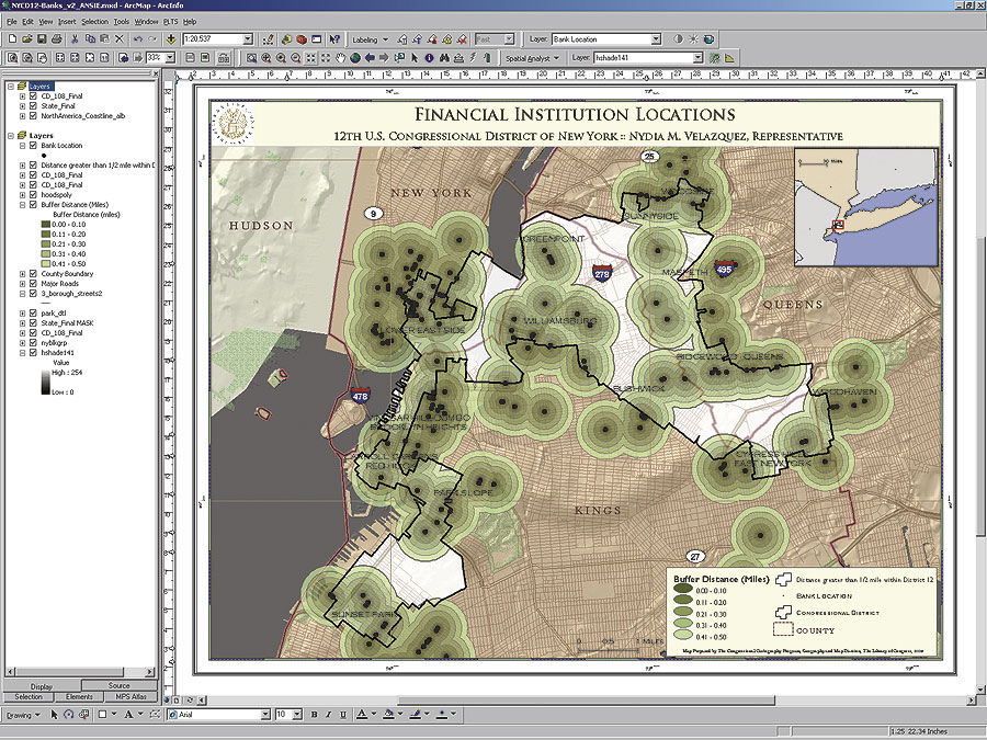
Currently, the more sophisticated GIS requests from congress are just beginning, mainly because many staff members are only now catching on to the capabilities that GIS has to offer for their projects. An office may request a map of financial institutions in its district, when what it really wants to know is where the underserved financial areas in its district are located and why. CCP takes requests and inquiries to the next level by investigating the issue at hand and working side by side with staffers and analysts to educate and promote the value of GIS. Using ArcSDE on an Oracle database, CCP has compiled data from Tele Atlas/TomTom, the United States Geological Survey, and requested projects from its own central data repository. Esri's Professional Services Division assisted in the implementation of this database and also the strategy and planning of an enterprise structure that would be capable of handling a large number of requests, as well as future intranet applications for congress. This data infrastructure is also the foundation for the program's map templates, which led CCP to retain Esri Professional Services during the infrastructure implementation. Jacob Zonn, CCP analyst, states, "To create a strong enterprise structure from the bottom up, it was imperative that Esri Professional Services play a large role in the initial implementation, especially since our program uses Esri software to deploy our products." For more information, contact Ginny Mason (tel.: 202-707-8520) and Jacob Zonn (tel.: 202-707-2267) at the Library of Congress, Geography and Map Division, or Gerry Clancy, Esri Professional Services (e-mail: gclancy@esri.com). |