Summer 2006
Summer 2006 |
|||||||
|
|
|||||||
Analyzing Library Use Patterns Geospatially
Colorado State Library Conducts a Variety of Projects with GIS |
|||
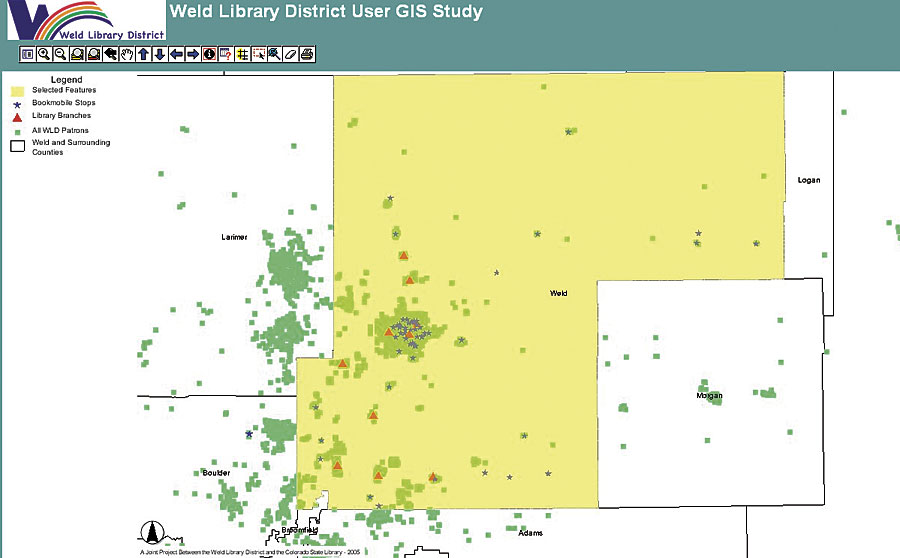
Each project consists of 10 layers:
The source data includes U.S. Census, TIGER files, and user records from the participating libraries' Integrated Library System (ILS). The user records created within ILS generally are used to control the circulation of materials, allow access to licensed databases and materials, and manage the use of computers and related hardware within library buildings. While all ILS software packages offer reporting modules, none offers any geospatial analysis capabilities. The user data extracted from ILS is run through a preprocessing program, which standardizes data for geospatial use and makes street address information as reliable as possible. In addition, the preprocessing removes any data about the individual that might be considered sensitive. The entire patron file is geocoded and built as a layer for the project. The second user layer is built of only the records that fall within the defined legal service area of the library and where a valid street address is included. This legal service area layer is also linked to the census tract, census block, voting district, and school district data. ArcGIS Desktop (ArcView) software is used to geocode patrons and to assemble the projects. These projects are then published to the Web using ArcIMS software. By using the Esri suite of software and providing access over the Web, training requirements at the libraries are minimal. Case Study: GIS at Weld Library DistrictThe Weld Library District (WLD) and the Colorado State Library began working on a GIS mapping project in late 2004. A final version of the project became available in mid-2005. WLD serves the 230,000 residents of Weld County and covers a geographic area of almost 4,000 square miles. Currently, WLD has 110,000 registered users, or about 48 percent of the population. Weld County has been predominantly a rural, agricultural area, but a number of factors have converged to create a growing population in a booming housing market and new job opportunities. The use of the GIS mapping project at WLD focuses on three areas—marketing, service delivery planning, and governance. Marketing—WLD has a stated goal that every resident of the district will use library services at least once a year. Mapping data is used to locate census demographic information that includes age, sex, and language, which is then compared with the library user data that identifies the same characteristics. This pinpoints areas in the district where the marketing penetration goals are falling short. For example, in a rural area in the northeast quadrant of the district, census tract 2501 contains 3,681 people, two-thirds of whom are adults. There are several bookmobile stops in this area. When the census data is compared to the library user data, approximately 1,000 individuals with borrower cards are identified, and two-thirds of these borrowers are children under the age of 18. Therefore, most adults in the area don't use the libraries, and this population segment has been targeted for future marketing studies to best determine how to serve the adult residents. Service Delivery Planning—The policy of the Library Board is that new library facilities should be positioned at least five miles apart. Using GIS mapping data and in cooperation with the Weld County Planning Office, maps were constructed to identify areas that lie outside of the five-mile radius of an existing facility. In one area, 1,000 people, most of whom are over the age of 40, were identified. The GIS mapping project shows that 60 percent of those residents have library cards and are active patrons of a library that is five miles or more away. The conclusion of the library is that the area is being served adequately. In another area of 3,200 people, 661 library users are shown, most of whom are children registered as bookmobile users. The conclusion is that the area is not being adequately served by the district, and alternatives are being considered. Governance—Another map prepared for the Library Board illustrates the WLD library users who reside outside the district. The GIS mapping project provides a graphic presentation of the fact that almost 10 percent of the users are residents of neighboring counties. Several neighboring library districts have done similar studies to identify how many WLD residents use their libraries. Together, the maps illustrate both the fluid boundaries between nearby public libraries and demonstrate the statewide commitment to resource sharing in action. Future PlansPublic libraries in Colorado are reporting value in their GIS mapping projects. For the rest of 2006, another six projects are currently in the queue. In addition, other projects have been built specifically for the Colorado State Library staff to present to decision makers and analyze the use of various statewide library projects by counties and state and federal congressional districts. At WLD, one of the unexpected results was a project to clean up and standardize the patron data in the local ILS. Although the GIS mapping project was initiated shortly after a major software upgrade that had included a purge of inactive patrons, the information presented in the mapping project magnified data errors and inconsistencies in the user file. As a result, WLD began a comprehensive in-house project to update and standardize borrower records to add data like birth dates and gender and standardize the data format in each field. This project will assure that when the next layer of library users is built, the data will be even more useful. More InformationFor more information, contact Steve Wrede, senior consultant, Colorado State Library (tel.: 303-866-6975, e-mail: wrede_s@cde.state.co.us), or Janine Reid, executive director, Weld Library District (tel.: 970-506-8563, e-mail: jreid@weld.lib.co.us). |