Summer 2006
Summer 2006 |
|||||||
|
|
|||||||
Garland, Texas, Improves Its Water Vehicle and Service Order Tracking Using GIS |
|||||
|
By David Jacobs and Fred Souza, City of Garland, Texas
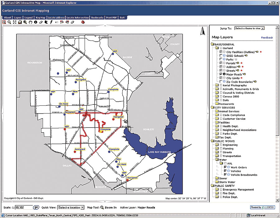
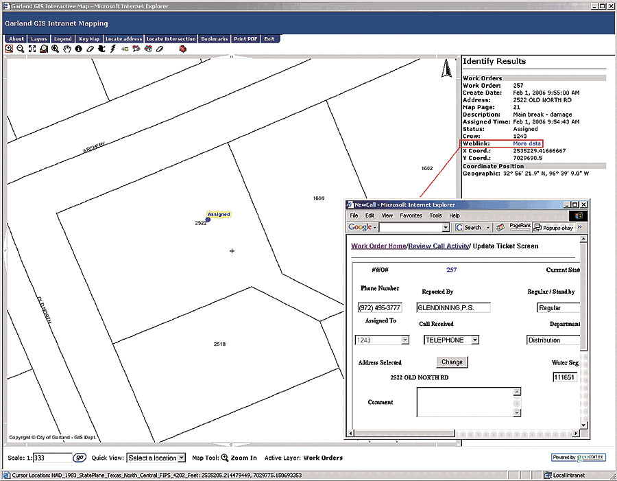
Of course, this mushrooming network of infrastructure requires maintenance. Knowing where 40 or more vehicles are per day in relationship to these maintenance demands becomes critical. Therefore, the city of Garland has implemented a custom automated work order and vehicle location system based on ArcIMS into its water utilities field operations. This system has strengthened the department's ability to better manage its field resources and service orders. The system is a hybrid locator system that is part of the department's strategic technologies plan and serves as a guiding light document for system enhancements and keeping pace with rising citizen expectations. One of the primary plan objectives was to use the existing ArcIMS system to deliver more than infrastructure mapping across the intranet. How the System StartedThe city of Garland GIS Department has been using ArcIMS to distribute GIS data throughout the organization for four years. The water utility data is converted into GIS format, initially as shapefiles and now as features in ArcSDE, and displayed as an ArcIMS interactive map; the water utility deployed in-vehicle mobile digital terminals (MDTs) to diminish the need for paper maps. The next step taken by the water utility was to find a way to integrate its work management system (WMS) with an automated vehicle location (AVL) system and ArcIMS. This need was accomplished by the introduction of ArcSDE and Geocortex Internet Mapping Framework software, a set of custom tools and interface for ArcIMS software-based mapping applications from Geocortex Internet Mapping, a division of Esri Business Partner Latitude Geographics, Victoria, British Columbia, Canada. The AVL system is part of the city's GIS Interactive Mapping System and is displayed on a customized browser for water utility interaction. In this way, current features, such as water main lines, valves, water meters, sewer main lines, and manholes, can be selected for viewing on the same map as vehicles and service calls. How It WorksA citizen telephones the Water Control Center with a request for service. A system operator enters information about the call into the WMS. At predetermined time periods, a screen refresh occurs on an AVL layer in the city's GIS interactive map and the address of the call is added to the map as a layer. Service calls with a crew assignment are entered into the WMS, colorized by water utilities divisions, and displayed in the GIS interactive map. A service call with an unassigned crew is colorized with a different color scheme in WMS and remains the color until the call is assigned to a field crew. The GIS map layer also contains all active vehicle locations, symbolized by a truck icon. The operator benefits by not only having a database record of the call but also having access to a visual rendering of all active vehicle locations in proximity to the service call. An operator chooses which vehicle should be assigned the call by using predetermined departmental procedures along with an AVL feature known as Nearest Vehicle to Address. This feature provides information in a tabular format of vehicles that are the closest to the call as well as the furthest away. The operator chooses the appropriate vehicle for call assignment, and colorization associated with the call point on the map changes to denote the call has been assigned.
Other AVL features include MapTip functionality so that, as the mouse is stationed over a call point or vehicle icon, a pop-up box is initiated to provide the operator with information about the service call or the vehicle. Call information is linked directly to WMS so the operator does not have to end one program and begin another. WMS is dynamically activated from a pop-up window, providing the operator with full update and recall functionality without leaving the AVL system. Because each vehicle is equipped with a GPS device, a state-plane coordinate plot is made at predetermined intervals and stored in the utility's work management database. At each refresh interval, the coordinate data is pushed to the GIS ArcSDE database and plotted on the interactive map. Additional important features of the AVL system are a speeding alert, an out-of-bounds alert, and a "bread crumb" feature that can be activated at any time to retrace the path of the vehicle by calendar date and time of day as it has traveled throughout the city. The AVL system was implemented to address management concerns regarding work scheduling, workload balancing, employee safety, and better utilization of its workforce. Until the system was implemented, water system operators had limited knowledge of the exact location of field vehicles. Other UsesOther primary system requirements were expandability, portability, and flexibility. The water utility desired a system that could be easily modified for use by other city departments without costly upgrades. Requirements were necessary due to the department's secondary mission of dispatching after-hours nonemergency 311-type calls. After-hours crews from departments such as Animal Control, Streets, Traffic, Facilities Management, and Customer Service routinely receive dispatched calls from water system operators after 3:15 p.m. until 6:30 a.m. the following day. The AVL system is a custom program designed for the water utility by Latitude Geographics, a Canadian company specializing in GIS Internet mapping. Other system components include an in-vehicle Panasonic Toughbook serving as an MDT along with a GPS unit and ArcIMS providing the interactive Web mapping capabilities. A total of 40 vehicles are equipped with system components and can be tracked anywhere throughout Garland's 57-square-mile city limits. BenefitsSome of the more obvious benefits of Garland's use of GIS include workforce leveling, time management, fuel and vehicular wear/tear savings, work scheduling, crew safety, and better managerial oversight of departmental field crews. Safety has been a key management selling point of the system. The known location of the vehicle is now available at all times so that, if emergency assistance is needed, it can be accurately dispatched and the individual has a better chance to be reached within a lifesaving time frame. From an oversight standpoint, the system provides improved safeguards for the department's $3 million rolling vehicle inventory. Vehicular whereabouts are now known at any point during the day or night. More InformationFor more information, contact David Jacobs, project manager, Water Utilities Department, Garland, Texas (e-mail: djacobs@ci.garland.tx.us), or Fred Souza, GIS analyst, GIS Department, Garland, Texas (e-mail: fsouza@ci.garland.tx.us), or visit www.garlandgis.com. |