Summer 2006
Summer 2006 |
|||||||
|
|
|||||||
English Independent School Implements GIS
A Multidisciplinary Approach to Education |
|||||
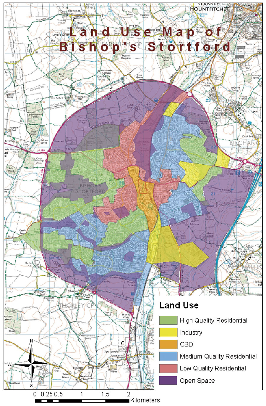
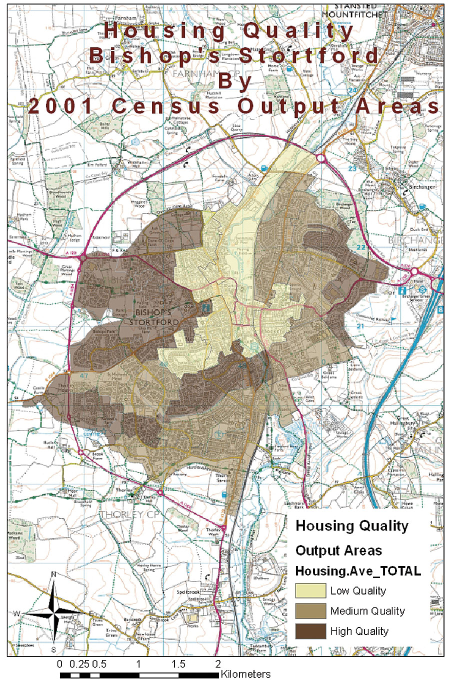
Geography classes are offered to students at Bishop's Stortford throughout their entire academic career at the school. In 2003, geography teacher Peter O'Connor completed a yearlong course in GIS, accredited by the United Kingdom's Qualification and Curriculum Authority. The value of using information and communication technology to support a variety of subjects had already been recognized by the school, and Bishop's Stortford was interested in maximizing its investment in computer hardware and increasing student interest and participation in using technology. To stimulate broader information technology (IT) use, the school encourages the evaluation of various software products and applications by its faculty. O'Connor successfully proposed an introductory class in GIS to Keith Irvine, the head of the Geography Department at Bishop's Stortford, and John Trotman, the school's headmaster. As part of his proposal, he had to justify to the department an educational need for GIS technology at the school, as well as the relevant topics for which it would be used and how it would fit into the exam syllabus. In addition, O'Connor had to demonstrate how grades could improve using the technology and how it would increase interest in geography. "I could see the benefits that ArcView could bring to our geography students," says O'Connor, "and how it could make the subject more interactive and engaging. Once my course had finished, I put the case forward for GIS to our school governing body."
In 2003, prior to the introduction of GIS, only 46 percent of pupils chose to take geography at the GCSE level. Following a redesign of the Year 9 Geography curriculum, which included the introduction of a six-week unit on the use and application of GIS, geography class enrollment nearly doubled the following year. Pupil feedback indicated that GIS was an important factor in motivating pupils to choose geography at the GCSE level and contributed to the highest increase in enrollment. O'Connor comments, "Although now part of the GCSE and A-level curriculums, I use GIS across a large range of my geography lessons for younger students as well because it is such a powerful and interactive tool. There is no shortage of topics in which we can use GIS; the bottleneck is how much time we can get in the IT Department." The Geography Department at Bishop's Stortford recently completed a student survey of those who completed their GCSE projects and asked whether the use of GIS was more or less likely to make them consider taking geography at the A level. Ninety-two percent concluded that GIS was more likely to encourage them to do so. GIS coursework has enabled the students to improve their analytical skills because the presentational aspect of their work is done much quicker using GIS than more traditional methods. By minimizing the tedious tasks, the students have more time to think about the theory behind their work and use the analytical capabilities of ArcView to test those theories. Due to the successful implementation of GIS within the Geography Department at Bishop's Stortford and the positive response from both students and teachers, the school is considering its introduction in other subjects, as well as support for related classroom activities. O'Connor concludes, "There is a continuing demand from employers in all sectors for those with good GIS and supporting skills, but more training materials and specific exercises are needed for teachers in the United Kingdom to start using GIS. Working with GIS providers, such as Esri (UK) Ltd., we can help create those materials, and other schools will be able to access and experience the benefits of GIS software for themselves." More InformationFor more information, contact Peter O'Connor, geography teacher, Bishop's Stortford College (e-mail: quaternary@bsc.biblio.net). |