Summer 2006
Summer 2006 |
|||||||
|
|
|||||||
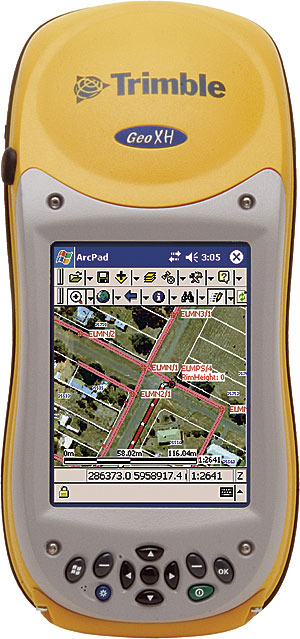
GeoCollector Comes Preloaded with ArcPad
Professional-Grade GPS for Superior Data Accuracy |
|||||
Esri will soon release a new Mobile GIS product line that will focus on integrating powerful GPS functionality with GIS workflows. Esri is partnering with Trimble, a leader in global positioning technology, to produce an end-to-end solution for GIS and professional-grade GPS. This series of products, called GeoCollector, will enable users to increase the accuracy of their data collection, resulting ultimately in a superior enterprise GIS. GeoCollector will include an ultrarugged handheld computer with integrated GPS receiver from the current Trimble GeoExplorer series. The software will comprise ArcPad, Esri's software for mobile GIS, and field mapping applications, as well as Trimble GPS processing technology. Three models of the Trimble GeoExplorer series covering the accuracy classes of subfoot, submeter, and 1 to 3 meter accuracy will be available. Each device will come preloaded with ArcPad, along with an extension that allows users to record the detailed GPS information required to produce reliable and accurate position data. Users can further increase data accuracy by postprocessing their GPS data directly inside ArcGIS Desktop software. Both the ArcPad extension and postprocessing capability are technologies developed by Trimble.
More InformationTo learn more about GeoCollector, visit www.esri.com/geocollector. You can also call Esri at 1-800-447-9778, call your Esri regional office, or contact your local reseller. Outside the United States, contact your local Esri distributor. |