Summer 2006
Summer 2006 |
|||||||
|
|
|||||||
Quality, Time to Market Significantly Improved with GIS at Rand McNally |
|||||||
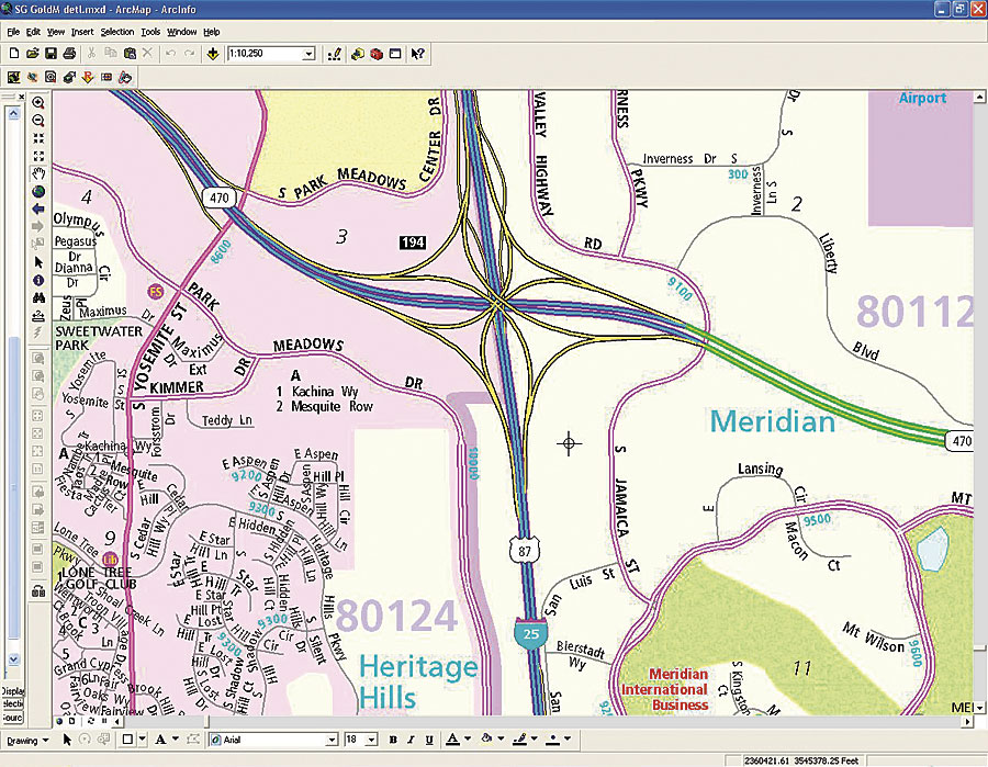
Celebrating its 150th anniversary in 2006, Rand McNally is headquartered in Skokie, Illinois, just outside of Chicago. In 1999, Rand McNally acquired west coast local street guide maker, Thomas Bros. Maps. Along with this acquisition, the company was interested in standardizing on a cost-effective environment to produce maps. It was also interested in creating a rapid development environment based upon standards in the industry. Thomas Bros. relied on Esri software to produce its street guides, while Rand McNally used Esri software along with other vendors' products to create and publish its commercially available maps. In 2001, Rand McNally embarked on a project that would significantly improve time to market and quality of street guides and fold maps and allow the data to be easily reused for electronic applications. Rand McNally wanted to find a way to leverage the experience of the Thomas Bros. production staff. The firm decided on standardizing on Esri tools for this project. "We needed to pick an environment for standardizing our map production that met our cartographic needs and was cost effective," says John McAvoy, a Rand McNally director. "These tools met our needs and the ArcObjects development environment allowed for rapid development." This project was named the Geo-Entity Management System (GEMS). GEMS is composed of seven major proprietary subsystems: Source Data Repository, Product Information Manager, Automated Names Placement, Indexing, Quality Assurance, Output, and Product Update Module. Each subsystem is built using ArcObjects, Visual Studio 6, and .NET.
The Product Information Manager (PIM) allows cartographers to define and persist hundreds of different products that are produced from the database. This includes specifying page layouts, data selection, display symbology, names placement rules, indexing rules, and output symbology. This information is stored in the database using Rand McNally's own software built on top of ArcGIS Desktop (ArcInfo), ArcSDE, and SQL Server. Rand McNally currently uses Maplex for automated names placement on each product page specified in the PIM. In addition, the Indexing module creates street and place-name indexes as specified by user-defined rules stored in the PIM. This proprietary software uses ArcGIS, ArcSDE, and the SQL Server database. Quality assurance (QA) and quality control are automated by special applications created in ArcObjects. These applications automatically identify and report changes made by cartographers and identify specific geometry/attribute conditions that are reported into a spatial queue and reviewed by QA personnel. The interface to this queue automatically presents the targeted conditions and zooms the user to the entities in question. The Output system takes information regarding a specific product defined in the PIM and automatically allows the user to create a subset or all the map pages of the product. Each map image is created from a selection of features from the ArcSDE database and rendered/output to a PDF format using ArcGIS Desktop advanced display options. This PDF is automatically enhanced further using proprietary prepress software before being sent to the printer for raster image processing. The Product Update Module compares versions of source data and automatically detects differences in geographic features of interest to Rand McNally cartographers. These differences can either be geometric or attribute in nature and are reviewed by cartographers based on a set of rules stored in the database. Changes are fed into a queue that allows the user to quickly discern the type of change and zoom in to the exact geographic location. Changes are accepted, rejected, or modified by the cartographer.
Rand McNally produces street guides and fold map products that are higher quality, more current, and more consistent in all major markets across the country than in the past. The firm is also able to reduce the time to market. The new environment also allows Rand McNally greater flexibility in reusing data for other electronic products, the Internet, and other high-quality print products, such as CustomView Wall Maps. Rand McNally also uses ArcGIS Desktop, Maplex/Map Labeling Engine, and ArcGIS Spatial Analyst software for its new series of educational Achievement Series World Wall Maps and Goode's World Atlas. The company created new software to work with Esri tools to create new techniques for shaded relief and perspective profiles. More InformationFor more information, contact Paul Elsberg, the Reynolds Communications Group (e-mail: pelsberg@reynoldsgroup.com, tel.: 312-541-9300), or visit www.randmcnally.com. |