Summer 2008
Summer 2008 |
|||||||
|
|
|||||||
Alpine Rail Link Developed with GIS |
|||||||||
Highlights
The Brenner Pass has served as a vital alpine link between Austria and Italy since early Roman times by supporting trade and transportation from northern to southern Europe. In 1991, the prehistoric Iceman, called Oetzi, was discovered in this area, suggesting that the pass provided egress through the Alps as long as 5,000 years ago.
Because the pass is at a lower elevation than other alpine routes, it was the designated location for the first relatively modern highway through the Alps, which was built in 1772, as well as the first transalpine railway, opened in 1867. Over the years, traffic through the pass has steadily increased, resulting today in a virtually continuous stream of cars and trucks that slowly traverse the well-known route while subsequently polluting the nearby alpine villages and meadows. Annual commercial traffic on the superhighway going through the Brenner Pass has increased from about one million heavy transport vehicles in the early 1990s to more than two million trucks today. Automobile traffic exceeds 10 million cars yearly. Recognizing the critical need to improve its transportation networks, the European Union (EU) initiated a series of studies and proposals that resulted in the Trans-European Transportation Networks (TEN-T) project, which was adopted by the EU in 1996. Briefly, TEN-T is a series of coordinated improvements to roadways, airports, railways, and water transportation networks designed to stimulate economic growth, competitiveness, and employment throughout Europe. The TEN-T studies revealed that road freight was expected to increase dramatically throughout Europe by 2020. It was concluded that while Europe was dependent on overland transportation, a more energy-efficient freight system was vital to both improve the quality of the environment and stimulate the economy.
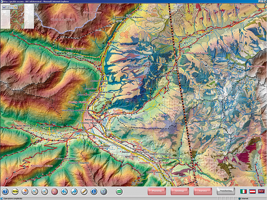
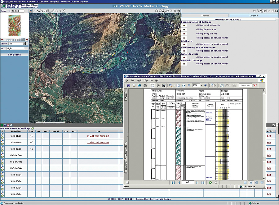
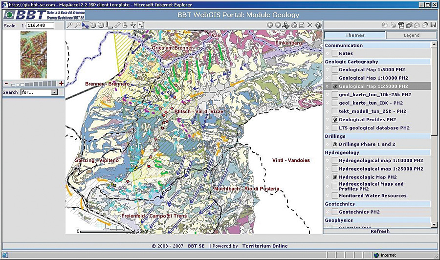
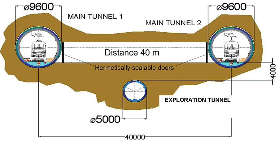
Axis no. 1 (TEN 1) of the TEN-T project is a revitalization of the rail network from Berlin, Germany, to Palermo, Italy. It is divided into eight distinct projects, and the estimated completion date for the entire railway corridor is 2040. Stretching from Innsbruck, Austria, to Fortezza, Italy, the Brenner Base Tunnel section of TEN 1 is 56 kilometers in length and will be completed by 2020. The tunnel is expected to take much of the existing truck and automobile traffic out of the Brenner Pass, transporting primarily freight (80 percent) but also passengers (20 percent) through the region by railway. The Galleria di Base del Brennero—Brenner Basistunnel (BBT SE) is the European public limited company entrusted with the design and construction of the Brenner Base Tunnel, considered to be the core of the European railway axis from Berlin to Palermo. The project is composed of two main tunnels connected every 336 meters by transverse tunnels for safety and maintenance purposes, as well as a third tunnel used for exploration purposes. Because of the breadth of the technical requirements necessary to complete the project, including design, geology, environment, and topographical analyses, and the vast area in which the project is being carried out, a considerable amount of data was collected during the analysis and design phases. The data acquired during the subsequent construction and operating phases will be added to this substantial database. To manage this comprehensive geographic database, BBT SE decided to adopt a modular and scalable GIS based on the latest Web technologies, which will enable everyone involved in the implementation of the project to access relevant geospatial information quickly and efficiently. BBT SE utilized WebGIS Framework tools (mapAccel) from Territorium Online (a Business Partner in Bolzano, Italy, of Esri Italia, Esri's distributor in Italy), which are designed to work in conjunction with ArcGIS Server technology. The scalable architecture provides different levels of use based on the interest, expertise, and access privileges of the user.
The GIS applications developed are divided into two primary tiers. The internal GIS application is used by BBT SE engineers for project planning and development. The external application is for use by the general public so that they can easily follow the progress of the project. The multilanguage applications are structured in one public and five internal views. All are derived from a single master view. The system is thus composed of six thematic modules and constitutes the core of the BBT SE GIS architecture. The modules include geology, planning, water monitoring, topography, land parcels and owners, and the public module. Data access is provided according to authorization and restriction, as well as the need for specific functionality. Data access control and access rights must be enforced because the project uses some data that is considered sensitive. Therefore, it is necessary to implement some restrictions regarding viewing and editing capabilities not only for security reasons but also to minimize the chance of introducing errors into the database. The general public is encouraged to access the BBT SE site through a dedicated Web portal (www.bbt-se.com) or by using one of the multimedia touch screen kiosks located in public places in Innsbruck and Fortezza and in the main railway stations in the project area. Commenting on the development of the GIS applications, Rosalia Di Bella, doctor of engineering and BBT SE's GIS administrator, says, "In order to define in detail the architecture of the GIS applications and ensure that they meet the real needs of those who will use them, a series of interviews was conducted with all BBT designers and coworkers. These interviews not only highlighted the expectations of each sector with regard to the corporate application but also the kind and quality of data available for immediate inclusion into the GIS database and which data would be acquired from future studies and investigations. Because of the server-oriented architecture, our data is collected and verified just once. This centralized management of the data eliminates redundancy and allows us to provide different hierarchically organized views of the data according to specific parameters."
Continues Di Bella, "The creation of our system for the cross-border territory of the Brenner Base Tunnel project was not only very demanding because of the need to harmonize the different cartographic reference systems used by Italy and Austria but also from a technical perspective, because both countries organize some of their administrative data—for example, their cadastral data—in different manners. Also, heterogeneous data formats could not be immediately incorporated into the GIS. The need to develop a multilingual user interface and data storage capability for German, Italian, and English speakers also expanded the scope and complexity of the project." Di Bella believes that the ArcGIS Server software-based applications developed by BBT SE could become a standard of reference for other parts of the TEN 1 corridor. In addition, with the recent formal adoption by the European Parliament and Council of the Infrastructure for Spatial Information in Europe (INSPIRE) directive, which mandates the implementation of standards for exchanging, sharing, accessing, and using spatial data among EU member states, it is likely that the GIS development work performed by BBT SE will have long-ranging effects on other TEN-T projects. Summarizing the GIS implementation for the BBT SE project, Di Bella says, "GIS offers a general overview of the entire project area by organizing all available data (basic mapping, results of analyses, etc.) in a well-structured, georeferenced database. If you consider the size and complexity of the project area and the large amount of data produced by the technical sectors of BBT SE, the use of a GIS system seems to be the only possible solution to guarantee efficient management without redundancies in the data. "In addition, the modular architecture used for developing BBT's GIS allows a horizontal integration by creating new thematic modules as well as a vertical integration by implementing new functionalities on the base module, which can be transferred to the thematic modules. Thanks to this mechanism, the system is highly flexible, and it is possible to easily adapt it to the changes that will arise during the entire life cycle of the project. Therefore, the GIS is not only an instrument for archiving and analysis during the design stage but also a valid support system for data control and management during construction. Once the tunnel has been built, it may be used as a decision support system for monitoring, operations, and maintenance activities." Di Bella concludes, "Because of its capabilities as a powerful system for the spatial and temporal analysis of different kinds of data on both large and medium scales, a GIS is much more able than other systems to support a complex engineering project of this nature during all its construction stages." More InformationFor more information, contact Rosalia Di Bella, BBT SE's GIS administrator (e-mail: Rosalia.DiBella@bbt-se.com, tel.: 39-0471-0622-33, Web: www.bbt-se.com). |