Summer 2008
Summer 2008 |
|||||||
|
|
|||||||
With GIS Technology, Dewberry Refines FEMA Flood Insurance Rate Mapping Process
GIS-Based Flood Mapping at FEMA |
|||||
Highlights
Beginning in 2004, the U.S. Congress and president George W. Bush responded to National Flood Insurance Program (NFIP) requirements and feedback by federal, state, and local program stakeholders by supporting a multiyear, billion dollar program called Map Modernization. Managed by the U.S. Department of Homeland Security Federal Emergency Management Agency (FEMA), as part of the National Flood Insurance Program, the plan embraced production of new digital flood insurance rate maps (DFIRMs), delivered in an industry-standard GIS format. DFIRMs provide more accurate and up-to-date flood hazard information and enable community officials and citizens to make decisions and manage risks at a local level.
To coordinate and provide better local and state relief, the United States and its territories are divided into 10 FEMA regions. Rather than choosing one contractor to create a nationwide GIS-centric DFIRM, FEMA implemented its Map Modernization through regional contracts and state and local government cooperating technical partners. Dewberry, an Esri Business Partner in Fairfax, Virginia, is a GIS-focused engineering and surveying firm with a long history of serving FEMA. Dewberry has been awarded FEMA contracts for the Map Modernization effort in a number of regions across the United States. Dewberry has six regional offices and several hundred staff engaged in the multimillion dollar Map Modernization. With staff, contract partners, and FEMA clients located across the country, Dewberry realized that working with a geographically dispersed project team could present its own flood of issues. To handle an intensive workload and decentralized team, the firm reengineered its flood mapping process by taking the geospatial technology that preceded the Map Modernization program and applying it to an enterprise-level automated engineering and map production and workflow system called GeoFIRM. Geospatial Data StreamliningAt its core, GeoFIRM relies on a multiuser centralized geodatabase. This technology makes it possible for project members to instantaneously view data; easily edit the database; and readily access Dewberry DFIRM project data, such as digital imagery, orthophotography, scanned paper flood insurance rate maps (FIRMs), light detection and ranging (lidar), and engineering data. Furthermore, GeoFIRM's engineering and mapping teams can collaborate directly on geodatabase-driven projects via the Internet. Dewberry built GeoFIRM around a Microsoft SQL database and ArcGIS software. Using the geodatabase-centric ArcSDE technology in ArcGIS, GeoFIRM became Dewberry's central repository for engineering and mapping spatial and nonspatial DFIRM data. GeoFIRM's GIS architecture allows project members to focus more on adding value to the data in the geodatabase rather than on just delivering products, such as raster maps and DFIRM databases. The new process introduced in the GeoFIRM platform is as big a change for Dewberry as it is for FEMA. "Dewberry has been working on mapping programs for FEMA since 1974, so introducing GeoFIRM drastically affected how our engineers think about a project," says Grant Smith, one of Dewberry's indefinite delivery/indefinite quality project managers. "The project focus is its spatial model and data rather than an end-product model or map." Dewberry built a series of automated toolkits using the ArcObjects technology inside ArcGIS to assist project members in the new platform. The toolkits facilitate the modeling process automatically by managing the input and output requirements for each model or task. GeoFIRM provides tools for terrain, survey, hydrology, hydraulics, mapping, and DFIRM production. According to Smith, the custom-created toolkits have increased engineering accuracy and quality, while drastically reducing FIRM production cost and time.
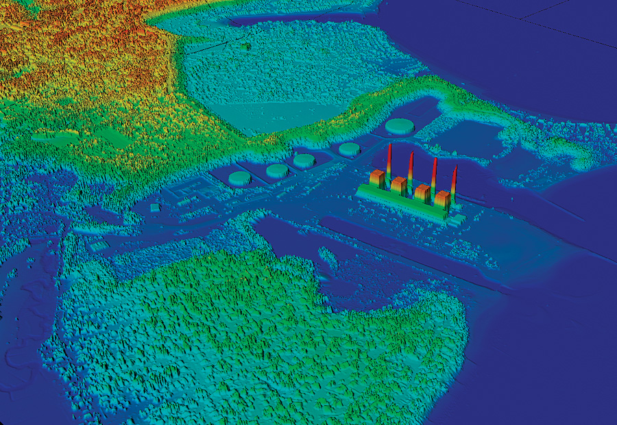
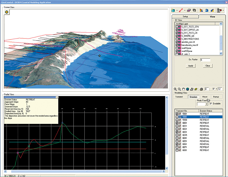
"One of our key paradigms is to let the computer do what it can do best, which is a lot of number crunching, analysis, and what-if scenarios," says the manager of Dewberry's GeoFIRM Development Team, Ken Logsdon, Jr. "We let the computer run through a series of automated routines, and then GeoFIRM tools visually present the engineer or the geographer with the results at key stages of the process so they can make informed decisions and infuse better engineering and mapping judgment. "Essentially what we built," continues Logsdon, "is a system that's scalable across our enterprise; revolves around industry-standard and industry-leading software and hardware components; and allows our team members to collaborate across the United States in appropriate teams with the best professional mix, while having access to all project data and edits in real time. While our teams are focused on adding value to the GIS database, we have the tools on the back end of the system that actually produce our product deliverables." Map Modernization Sees the LightAdvances in remote-sensing technology have made the acquisition of high-quality elevation data, such as lidar, more commonplace in flood hazard risk assessment and mapping projects. By incorporating lidar technology into GeoFIRM, Dewberry can provide FEMA with automated bare-earth, hydroenforcing, and quality control analysis techniques. Dewberry's team of remote-sensing, geodesy, and GIS specialists helps plan, manage, and execute every facet of a lidar mission so that the results meet the demanding requirements for flood mapping. From mission design to independent QA/QC, the team ensures that mission specifications meet project needs and resulting data attains the designed specifications. The company has been involved in lidar mission planning, design, and execution since the technology's earliest application to flood mapping. Dewberry's subject matter experts, David Maune and Tim Blak, not only wrote the de facto standard for lidar acquisition for FEMA, but Maune's Digital Elevation Model Technologies and Applications: The DEM Users Manual (American Society for Photogrammetry and Remote Sensing, 2007) is widely considered the lidar users' bible. While the availability of lidar data has helped significantly increase the accuracy of the flood maps, it might have become increasingly challenging to manage the huge datasets produced by lidar in a GIS. However, Esri addressed this issue when it introduced the terrain datatype in ArcGIS 9.2. The software more efficiently stores large topographic data in both file-based geodatabases and ArcSDE datasets and provides on-screen visualization in a dynamic triangulated irregular network (TIN) format. Dewberry leveraged this technology in its GeoTerrain toolset within GeoFIRM and extended the usability of terrain data. Dewberry uses GeoTerrain in coastal and riverine (stream and river) studies and has delivered significant modeling and mapping efficiencies across various tasks for DFIRM production. DFIRMs produced using Dewberry's GeoFIRM software have helped protect the lives and property of more than 40 million people. Even though all the complicated tools within GeoFIRM are not evident to the public, the public is affected by the software's impact. For example, after Hurricane Katrina, Dewberry mapped the flood elevations along the coastlines of Mississippi and Louisiana, representing 19 counties. GeoFIRM's GeoCoastal toolset enabled the project team to statistically analyze field survey data of observed high-water marks and to map inundation and debris limits. The resulting data was used to help establish advisory base flood elevations to guide recovery effort from the catastrophic storm. More InformationFor more information, contact Jeffrey R. Poplin, department manager, Dewberry GIS Program Services (e-mail: jpoplin@dewberry.com). See also "The FIRM." |