Summer 2008
Summer 2008 |
|||||||
|
|
|||||||
Italian Province Tackles Hydrological Hazards with GIS |
|||||
Highlights
The autonomous province of Bolzano is located in northern Italy and shares a boundary with Austria. With a surface of 7,400 square kilometers, Bolzano is mainly mountainous, its elevation ranging from 200 to more than 3,800 meters above sea level (ASL). Notably, a conspicuous 37 percent of the province's surface has an elevation of more than 2,000 meters ASL, with another 49 percent of the surface between 1,000 and 2,000 meters ASL. Urbanized and agricultural areas are therefore restricted to the valley floor along the main water streams. In the last 30 years, human activities in these areas have greatly increased; thus, so has the demand for hydraulic structures.
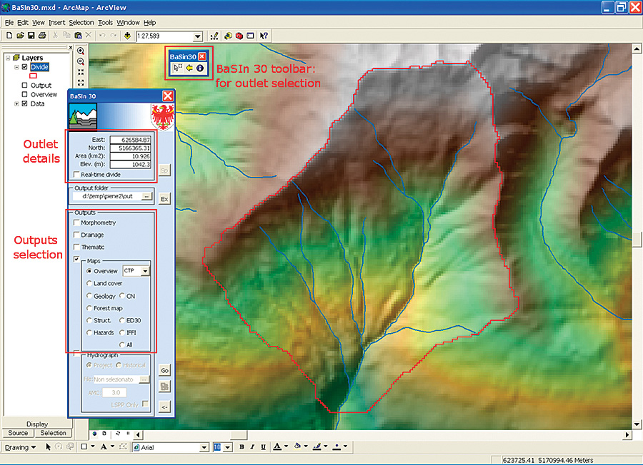
Bolzano's Department 30 is the province's agency in charge of resolving the conflicts between natural environment and human needs. Specifically, Department 30 manages the construction and maintenance of engineering measures for the mitigation of hydrologic and geologic hazards, such as check dams (small dams used to decrease stream flow velocity), dikes (embankments used to prevent areas from being flooded by stream overflow), and drains (used to carry away excessive storm water). The planning activity of Department 30 strongly relies on the availability of detailed, up-to-date spatial information about the environment and, more specifically, about the watershed where hazards need specific mitigation. For this purpose, in the past years, the province has designed and implemented several GIS geodatabases that include generic datasets, such as digital elevation models, land cover, land-use maps, and orthophotography. Also included were more specific datasets, such as the inventory of historic floods and debris flood events and the inventory of the hydraulic structures already in place. While creating and maintaining a geodatabase with all the datasets needed by the planners are fundamental, it is also important to make those datasets easily available and usable. A specific framework project called the Information System for Hydrogeological Hazards and Risks (IHR), sponsored by the European Commission among others, was devised to make the information needed in risk management accessible to Bolzano's planners in a simple and standardized way. As part of the IHR project, the Basin System Information of Department 30 (BaSIn 30) application was designed to simplify the extraction, at the watershed level, of the most relevant information for the purpose of planning new hydraulic structures. Since most of the department's flood managers were already familiar with the ArcGIS Desktop software platform, BaSIn 30 was implemented as an ArcGIS Desktop extension. The input data required by BaSIn 30 is all spatial and includes general layers about land use, geology, and morphology and more specific layers about the hydrologic network, hydraulic structures already in place, and hydrologic hazards. Using BaSIn 30When a user in Department 30 has selected a suitable outlet, on the basis of a digital elevation model (DEM), BaSIn 30 extracts the divide of the watershed and visualizes it. At that point, the user can select the desired outputs, and BaSIn 30 clips the required input layers based on the watershed divide. Then, the clipped layers are processed to extract the information required to produce the desired reports. The outputs include information about several characteristics of the watershed in the form of maps, statistics, synthetic indexes, and charts. These characteristics include watershed morphology (elevation, slope, and aspect); watershed drainage (drainage density and hierarchical stream classification); and other thematic relevant aspects, such as land use, geology, hydraulic structures inventory, historical flood events, and hydrologic hazards. In addition, by means of hydrologic simulations, details about the response of the watershed and rainfall are also provided. All these outputs are presented to the managers at three different levels, with increased structuring. At the first level, outputs include spatial layers about the watershed (simply obtained by the clipping operations), database tables, text, and image files obtained by querying and processing the spatial layers. Although these particular first-level outputs present the highest granularity and detail, they are nonetheless unstructured and require a good GIS and hydrologic knowledge to be properly understood and used.
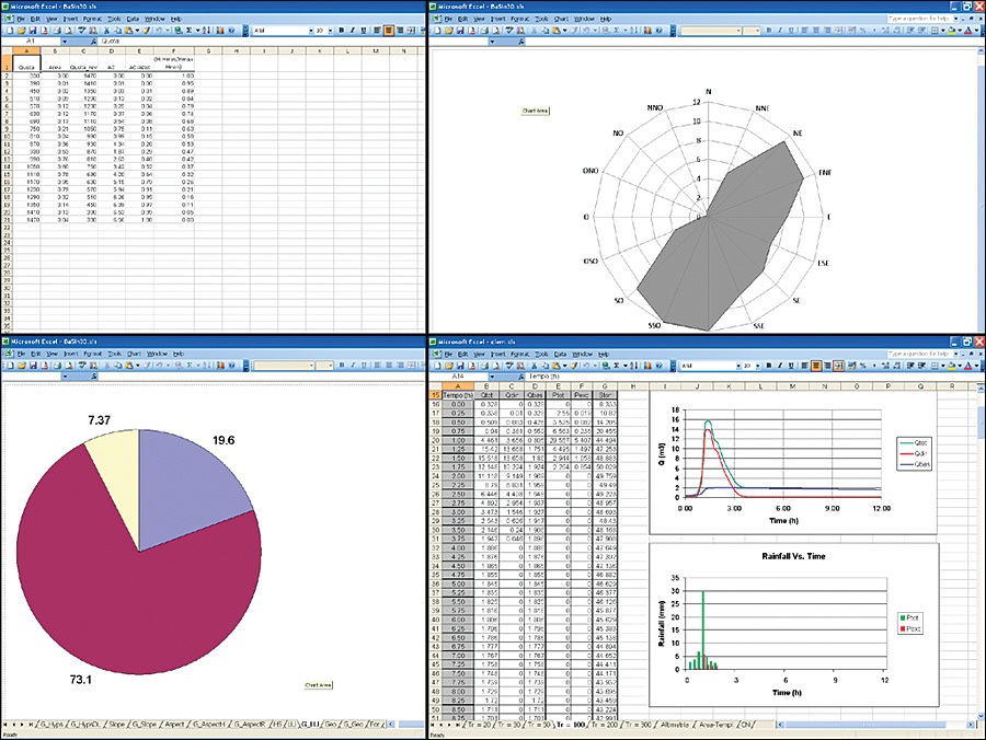
At the second level, outputs include several Microsoft Excel spreadsheets containing both a selection of level-one outputs and extra information in the form of mainly statistics and charts. At this level, the outputs are already structured enough to be immediately utilized by managers. Outputs in the third level include a well-organized report containing a selection of level-one outputs combined with a selection of indexes and charts from the second-level spreadsheets, organized in chapters and subchapters. Third-level reports contain the most relevant information to characterize the watershed for planning purposes and can be used as is or opened in a word processing system for further editing. The ArcGIS Desktop reports generated in BaSIn 30 are meant to become part of the standard documentation of every new project managed by Department 30 involving the construction of new hydraulic structures. More InformationFor more information, contact Alberto De Luca, Geomatica e Ambiente (e-mail: info@geomaticaeambiente.it), or Diego Mantovani, Autonomous Province of Bolzano-South Tyrol (e-mail: diego.mantovani@provinz.bz.it). |