Summer 2008
Summer 2008 |
|||||||
|
|
|||||||
USGS, U.S. Congress, Media, and Response Organizations Around the World Rely on ArcGIS Authored Maps
Temblor Reports Gain Fast Turnaround |
|||||
Highlights
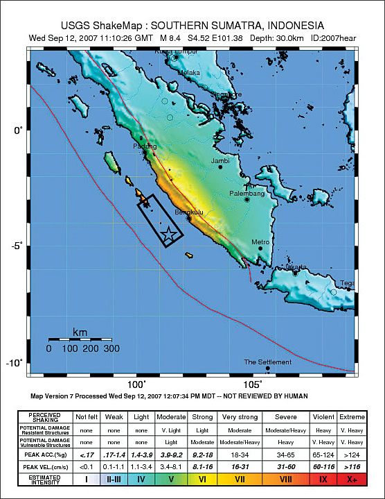
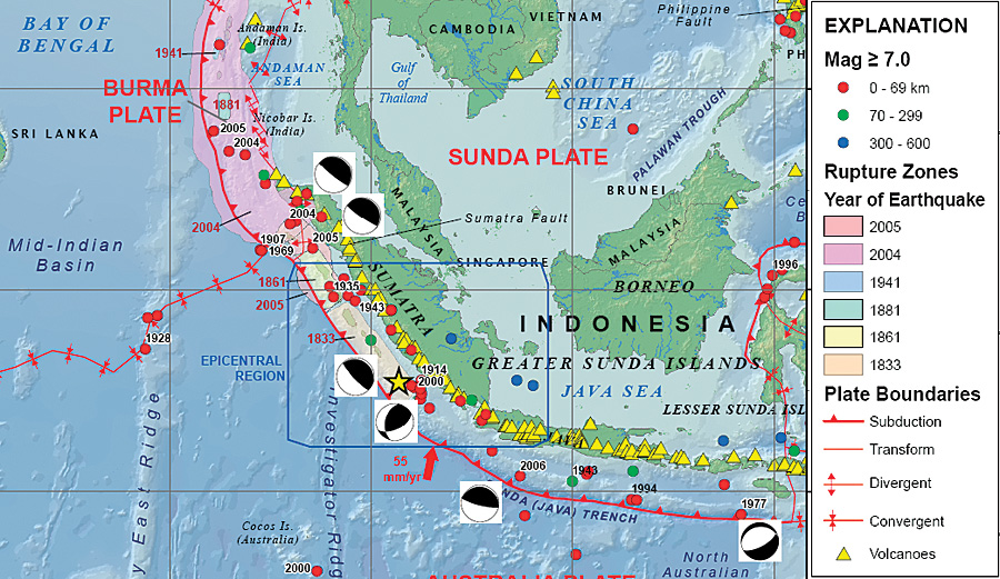
Using GIS geodatabase technology, the United States Geological Survey (USGS) is able to turn out earthquake event reports amazingly fast. On December 26, 2004, the fault generated a magnitude 9.0 earthquake, initiating a tsunami that killed more than 131,000 people in Indonesia's Aceh province and left many homeless. The wave was so massive it also damaged Malaysia, Thailand, India, Sri Lanka, Myanmar, Maldives, Somalia, and South Africa and was felt as far away as Mexico. Since August 2007, the region has experienced four earthquakes with magnitudes greater than 7. Earthquake activity continues to plague the region.
This continuing unrest has been carefully monitored by Susan Rhea, a geophysicist and GIS professional at the USGS National Earthquake Information Center (NEIC) in Golden, Colorado. Her job is to map significant earthquake events in the region as soon as they happen. These GIS-authored maps are released to the U.S. Congress, media groups, and response organizations around the world. Rhea has been using ArcGIS products for years, but the capabilities of ArcGIS 9.2 have increased the rapidity with which she is able to author earthquake event maps. Working with Esri Professional Services, NEIC had recently completed a project to streamline the process of generating informational posters that USGS creates after major earthquakes. These posters contain maps and diagrams to show the location and characteristics of the earthquake, aftershocks, and related historic quakes. On September 15, 2007, South Sumatra suffered a magnitude 8.4 earthquake. Within two hours of the event, Rhea had compiled maps that were made available for a press conference that same morning at the USGS National Earthquake Information Center. To optimize query performance, ArcGIS 9.2 was able to manage groups of records in a compressed file geodatabase feature class. The arrangement of compressed feature classes into blocks, stored in a seamless database, makes the task of authoring maps using vast amounts of data simple and fast. As
The streamlined method has done away with time-consuming work processes that included data preprocessing steps, which required performing conversion tasks to prepare various data, such as Digital Chart of the World maps. No longer does Rhea need to interact with a multiuser database management system. Because the ArcGIS 9.2 file-based geodatabase allows for storing data seamlessly, Rhea has decreased the map output time from seven to two hours. "The file geodatabase is a godsend," claims Rhea. More InformationFor more information, contact Susan Rhea, USGS geophysicist (e-mail: rhea@usgs.gov), or Earl Sarow, Esri Professional Services (e-mail: esarow@esri.com; tel.: 303-449-7779, ext. 8238). |