Summer 2009
Summer 2009 |
|||||||
|
|
|||||||
New Jersey Audubon Society Uses GIS to Create Trail Maps
Discovering Gems of Wildlife Viewing |
|||
Highlights
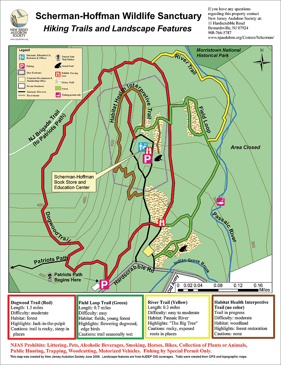
New Jersey Audubon Society (NJAS), a nonprofit environmental organization, is dedicated to fostering an environmental awareness and a conservation ethic among New Jersey's citizens. With 36 wildlife sanctuaries, many of them right in people's own "backyards," these mostly undiscovered gems offer a number of wildlife viewing experiences for New Jersey residents. So what is the best way to get people out and to try nature? Provide accurate maps to help make the experience enjoyable. Maps that identify trail length, highlights, and cautions remove fear of the unknown and encourage a little exploration. In addition, by mapping the sanctuaries, NJAS is able to highlight places to see rare wildlife and habitats, as well as identify areas that should be closed due to the presence of threatened or endangered species. While NJAS's nine staffed sanctuaries have been successful in getting people out on the trail, the unstaffed properties remain open but largely unused. NJAS's task? To bring these ecological gems to the attention of New Jersey residents and encourage passive recreation.
It rapidly became apparent that simply publicizing the sanctuaries was not enough. These sites have hiking trails that meander through grassland, forest, and wetland habitat. Many sites have trails in rugged terrain, while other locations offer a simple, relaxing walk suitable for small children. A few of the sanctuaries had hand-drawn maps, but these were dated and generally lacked sufficient detail in terms of demonstrating unique habitat features as well as trail length and the ruggedness of the terrain. The system was clearly in need of an overhaul. The solution was to create computer-generated maps that not only show hiking trails but also offer relevant feature information about each sanctuary. NJAS had experience with ArcView and found that Esri's upgrade to ArcGIS Desktop provided even better mapping capability to help it achieve its goal. The staff was also able to use ArcGIS Desktop to incorporate New Jersey State Department of Environmental Protection shapefiles, specifically elevation, land-cover types, streams, political boundaries, roads, and sensitive wildlife habitat layers. Parcel boundaries were either generated using tax maps or uploaded from municipal GIS sites. To acquire trail and specific feature information not available as a GIS data layer, NJAS used ArcPad on a Pocket PC with a handheld GPS unit connection for satellite reception. Staff members walked each property with hiking trails or where trails were being developed while recording trail information in ArcPad. They collected site-specific data, such as parking, sanctuary nature center (where appropriate), overlooks, vernal pools, pollinator meadows, trail benches, and unique historical features. Using ArcPad and being on-site also gave staff the ability to map potential hazards, such as surface mines, using this accurately pinpointed information to reflect areas as closed or show caution. Back at the office, staff uploaded all the data into ArcGIS Desktop, and some amount of postprocessing was required. The editing feature allowed NJAS to smooth trail lines and add attribute table information, such as trail name, length, and description. To complete the map, NJAS included some additional data layers, such as elevation and parcels. Some additional postprocessing using New Jersey aerial imagery allowed staff to be more specific about certain landscape features (e.g., the presence of a small meadow in a forest) and, where applicable, other data layers, such as adjacent open space or state and federal parks. Once all data layers were set, staff members measured all trails for approximate trail length. Before the map layout was designed, they clipped the data layers so that only features within and immediately around the sanctuary boundary would be displayed. Then they manipulated the information for quick and easy visual interpretation. To get the average person out on the trail, it is important to create a map with sufficient content that is easy to read. To complete the final map picture, each sanctuary trail was identified with a brief description that included length, degree of difficulty, highlights, and cautions. For consistency, most NJAS trail maps shared the same basic format and layout, with variations reflective of special features of a particular property. NJAS's mapping effort has allowed it to promote its 15 hikeable sanctuaries, covering more than 55 miles of trails, full of excellent opportunities for watching and learning about wildlife and wildlife habitats. Visitors now have all the necessary details to plan their trip, from estimating hiking time to the most appropriate footwear and the specifics on terrain—all this offering a good start to getting out and trying nature. These maps have been incorporated into a booklet that briefly describes the history of each sanctuary, its flora and fauna, stewardship activities, and directions. Because NJAS used ArcGIS Desktop in the generation of its trail maps, its staff can easily provide trail updates or modify changes in land use or features. The most current maps are available for download from the NJAS Web site (www.njaudubon.org). Best of all, NJAS now has a collection of trail maps that looks professional, providing easy-to-interpret information that will encourage more passive recreation. More InformationFor more information, contact Gylla MacGregor, conservation ecologist, New Jersey Audubon Society (tel.: 908-837-9571, e-mail: gylla.macgregor@njaudubon.org, Web: www.njaudubon.org). |