Summer 2009
Summer 2009 |
|||||||
|
|
|||||||
A Portable Mapcentric Asset Management Application
Field Enterprise Asset Management for City of San Diego |
|||||||
Highlights
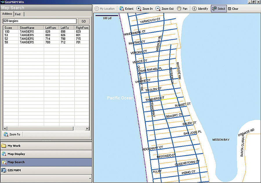
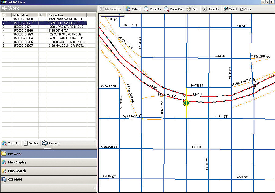
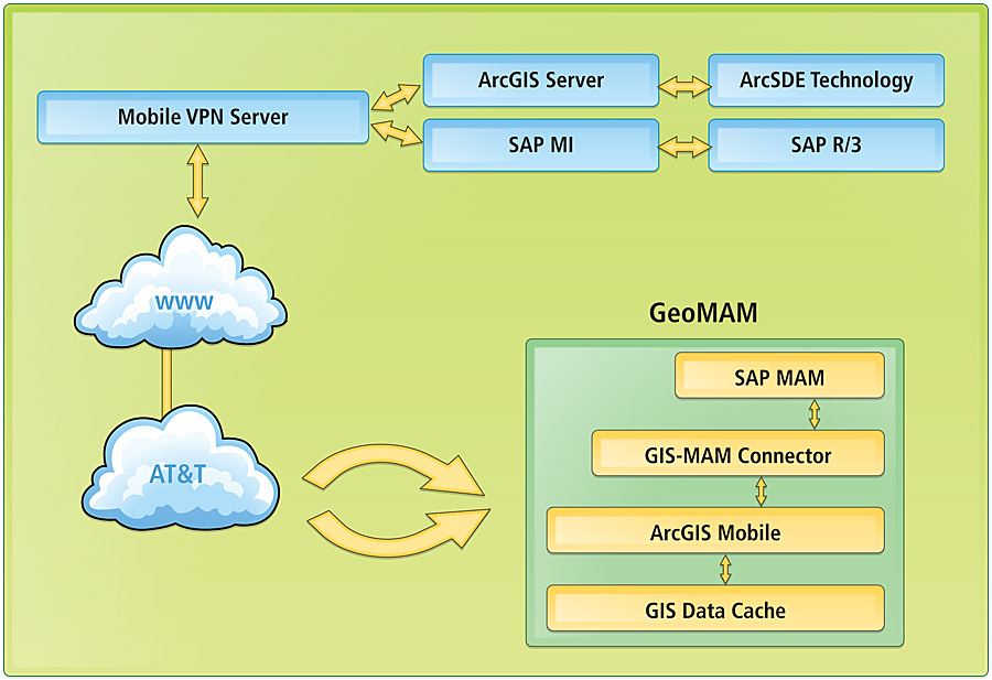
The City of San Diego's Geo Mobile Asset Management (GeoMAM) application integrates Esri's ArcGIS Mobile with SAP's Mobile Infrastructure (MI) module to facilitate enterprise asset management (EAM) in the field. GeoMAM was designed to be a portable, mapcentric asset management application that would provide field staff with real-time access to the integrated enterprise Esri and SAP system to reduce the time taken to address issues reported by citizens. SAP MI facilitates the communication between the mobile device and the enterprise SAP system, while ArcGIS Mobile provides access to the enterprise GIS based on ArcGIS Server. This communication is streamlined by a VPN connection between the mobile device and enterprise systems via AT&T's broadband cellular networks. Potential disruption in the broadband connection is handled by ensuring the use of data cached on the mobile device. The application has been deployed on ruggedized laptops that are connected to the city's enterprise systems over wireless broadband data networks. GeoMAM ApplicationThe user interface of the GeoMAM application is simple to use. Users log in to the application using their SAP login credentials and are presented with a list of work orders that have been assigned to them. Geographic locations of the work orders are displayed on the map in the right panel of the application. Standard map navigation and other GIS tools, such as Zoom In, Zoom Out, Pan, Identify, and Select, are available above the map display area. Users have the option to view the location and select the asset (piece of equipment) associated with a work order by clicking on it in the list of work orders.
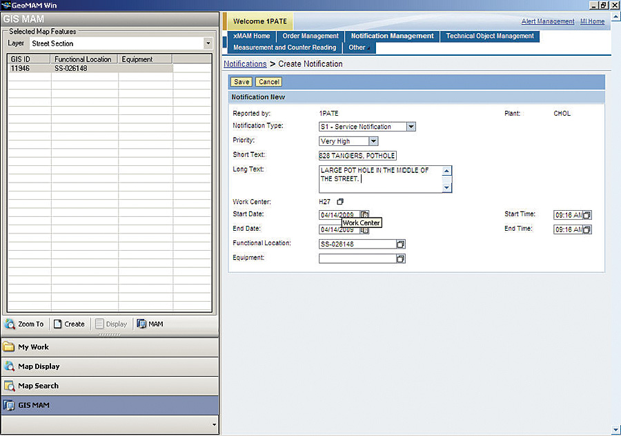
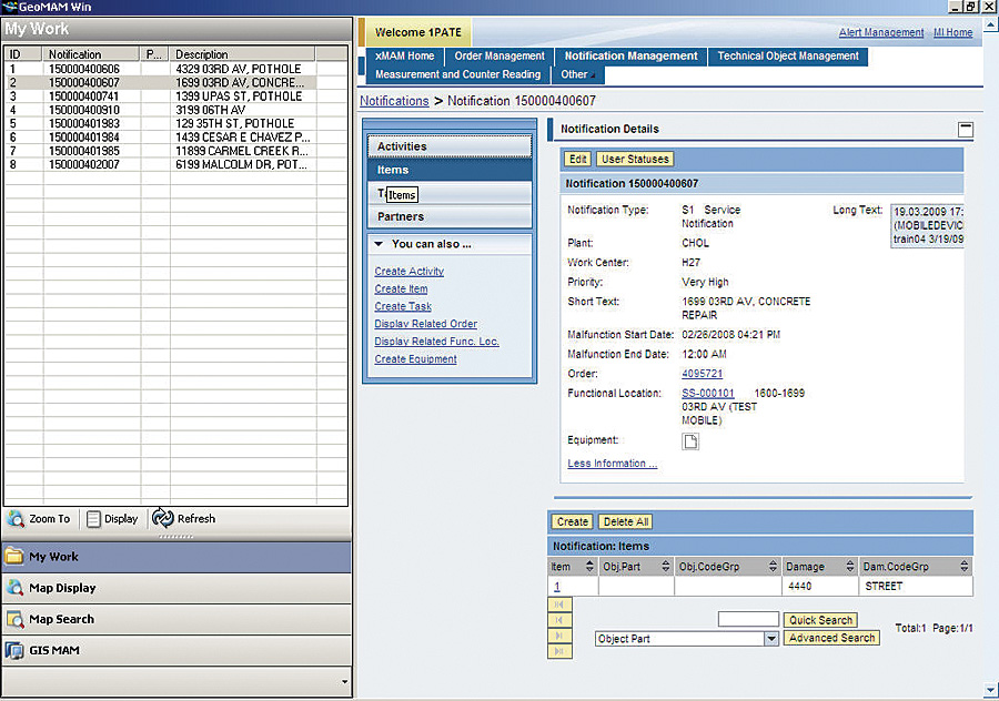
Tools for zooming to the location of the work order or viewing additional information related to the work order are available at the bottom of the left panel. Clicking the Zoom To button centers the map on the location of the work order and selects the equipment associated with the work order. The Display button presents additional work order information by replacing the map with the relevant SAP MI screen. Users can also update work orders with the SAP MI interface if they have the necessary privileges. All work order updates done by users in the field are transmitted back to the enterprise SAP system immediately. Conversely, any new work orders created in the enterprise SAP system are added to a user's list of open work orders immediately after they are created. Integration with SAP Mobile Infrastructure allows users to update work orders directly from the field. Details of the work carried out in the field and the time taken to resolve the problem can be recorded and posted to the enterprise EAM system directly from the field. The status of the work order can also be updated by the field crew. The GeoMAM application also enables users while in the field to create new service requests (notifications) for city assets by locating and selecting them on the map and clicking the Create button available under the GIS MAM menu option. This capability reduces the time it takes city staff to report and record issues with city assets.
The Map Display menu option of the application replaces the list of work orders with a table of contents that can be used to control the layers that are visible on the map. An ArcGIS Server dynamic map service is used to render the map in the GeoMAM application. Users can turn layers on or off to enhance the map. They can also toggle between the table of contents and the map legend. Users of the GeoMAM application have a robust set of search tools available to them under the Map Search menu item. An ArcGIS Server geocoding service allows them to zoom to a street address or a street intersection. They can also locate assets on the map by searching for them using feature attributes, such as the SAP functional location ID, or any other attribute. GeoMAM Application ArchitectureThe architecture of the GeoMAM application is illustrated here. More InformationFor more information, contact Elizabeth Mueller, EAM project manager, City of San Diego, California (e-mail: emueller@sandiego.gov), or Steve Benner, Esri (e-mail: sbenner@esri.com). See also "City of San Diego, California, Takes Enterprise Management to the Field." |