Summer 2009
Summer 2009 |
|||||||
GIS: Designing Our Future |
|||
By Jack Dangermond
With those words in 1954, influential architect Richard Neutra opened his seminal book Survival through Design. Neutra was an early environmentalist, taking an approach to architectural design that applied elements of biological and behavioral science—what he called biorealism, or the "inherent and inseparable relationship between man and nature." Fifteen years later, in his groundbreaking book Design with Nature, landscape architect Ian McHarg advocated a framework for design that helps humans achieve synergy with nature. Design and planning that take into consideration both environmental and social issues help us ensure that our resources are used appropriately and responsibly, to help us move toward a better future for all. McHarg's pioneering work not only had a fundamental influence on the up-and-coming field of environmental planning but simultaneously solidified the core concepts of the young field of GIS as well. In the 40 years since Design with Nature was written, a better world is the common goal all of us—geographers, planners, scientists, and others—have been striving for. Discussing his book during the Keynote Address at the 1997 Esri International User Conference, McHarg laid out a process by which "environmental data could be incorporated into the planning process." Rejecting the view of a future modeled after some idyllic environmental past, he instead was an early adopter of the view that we should be using our dominance of earth systems to help evolve the natural world and make it better, rather than conquer it. Powerful anthropogenic influence over earth systems represents not just a huge challenge but an equally huge opportunity—not humans versus nature, but humans with nature. "While traditional ecological research selected environments with a minimum human influence, I selected arenas of human dominance," McHarg said. Today more than ever, it is important to recognize the overwhelming impact of humans on the environment, that massive human impacts on the earth are a fact that's not going away, and that we stand at the crossroads. Thus, our challenge is to provide designers, engineers, planners, and others, with a set of tools and a framework for designing and managing the anthropogenic earth. Design for the Anthropogenic EarthI've recently become very interested in the relatively new field of earth systems engineering and management (ESEM), which concerns itself with the design, engineering, analysis, and management of complex earth systems. ESEM takes a holistic view of multiple issues affecting our earth—not only taking environmental, social, and other considerations into account up front in the design process but also looking at challenges from an adaptive systems approach, where ongoing analysis feeds back into the continual management of the system.
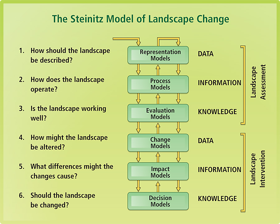
Braden Allenby, professor of civil and environmental engineering at Arizona State University and one of ESEM's founders, often emphasizes the undeniably dominant role humans have in earth systems. "We live in a world that is fundamentally different from anything that we have known in the past," says Allenby in his paper "The Metaphysics of the Anthropogenic Earth Part I: Integrative Cognitivism," "It is a world dominated by one species, its activities and technologies, its cultures, and the integrated effects of its historical evolution." McHarg was already moving in this direction in the 1960s, and today we understand that it is even more important to emphasize the anthropogenic elements of earth systems. In other words, at this stage of ecological evolution, humans are a significant, if not dominating, component of the natural environment, and all problems need to be addressed and decisions made with anthropogenic elements in the forefront. Allenby sees reasoned design and management in the age of the anthropogenic earth as our moral imperative, but the biggest obstacle to our success is that we are not set up to work, or even think, in this way. "We lack solid data and analytical frameworks to make assertions about the costs, benefits, and normative assessments of different . . . practices," notes Allenby in "Biomass Management Systems" in Reconstructing Earth. And this is why I believe that GIS and the emerging field of GeoDesign are critical to the success of approaches such as ESEM and other logical and rational models for dealing with the environmental and planning problems of ours and future generations. "We are being propelled into this new century with no plan, no control, no brakes." � Bill Joy, Cofounder and Chief Scientist, Sun Microsystems Designing Alternative FuturesThe key to developing a true understanding of our complex and dynamic earth is creating a framework to take many different pieces of past and future data from a variety of sources and merge them in a single system. GIS is a sophisticated technological tool already in widespread use by planners, engineers, and scientists to display and analyze all forms of location-referenced data about the health, status, and history of our planet. GIS enables a GeoDesign framework for analyzing and managing anthropogenic earth issues by allowing users to inventory and display large, complex spatial datasets. They can also analyze the potential interplay between various factors, getting us closer to a true understanding of how our dynamic earth systems may change in the coming decades and centuries. Carl Steinitz, an urban planner at Harvard University, originated many of the early ideas about the application of GIS for landscape analysis and urban planning. Steinitz developed a model of landscape change that enables design of alternative futures. Those alternative designs can then be evaluated in terms of their impact on the natural environment as well as their utility to the human population, and the alternative future that is projected to achieve the best balance can then be selected for implementation. With a debt of gratitude to Steinitz ("A Framework for PLF," Landscape Future), the GeoDesign framework also lets us design and test various alternatives, helping us make the most educated and informed decisions about the best possible future.
Is the earth getting hotter or colder? Is the stress human populations are putting on the planet contributing to climate change? What potential factors may significantly impact our ability to thrive and survive in the future? What additional sorts of environmental monitoring can we be doing today to improve decisions in the future? We are only beginning to understand how to approach these questions, let alone come up with scientifically valid answers. Only through careful observation of the data, application of scientific principles, and using GIS and other technologies do we have any hope of truly understanding the stressors and impacts on the incredibly complex systems that comprise our anthropogenic earth. It's also the key to making pragmatic, thoughtful, informed design decisions and proposing alternatives that allow humans and nature to coexist more harmoniously. Design with NatureDesign with Nature—rarely has a three-word title so eloquently summed up an entire tome. The most important word in that title is not design, nor is it nature. It's with. It sets the stage for design and nature working together in concert to achieve something that is bigger than the sum of the parts, a synergy of design and nature reaching toward the goal of the survival of the human species in particular and the planet in general. It's not a stretch to say that the development of GIS technology and the entire industry around it was profoundly influenced by the work of McHarg. He popularized the overlay concept and laid the groundwork for what was to become GIS, thus taking a number of budding young landscape architects and geographers and changing their lives forever. McHarg and I may have disagreed on some things, but we clearly shared the vision of using geographic analysis techniques to design a better world. Although we've made much progress in building the infrastructure to help us accomplish this monumental task, we're still not quite there yet. In fact, 28 years after Design with Nature was published, McHarg issued a challenge of sorts to attendees of the 1997 Esri International User Conference in his Keynote Address: "By and large, the ecological planning studies I did in the 1960s and 1970s have not been equaled, far less surpassed. And I think there has got to be a challenge; that is, we've got to be able to learn to do at least as well for regions and for the nation and, indeed, for the global environment as we are doing at the moment." Like McHarg's Design with Nature, Esri is also celebrating its 40th anniversary this year. It's no coincidence that both the concepts espoused within Design with Nature and the GIS work led by Esri launched almost simultaneously. When McHarg advocated this new methodology of taking geographic considerations into the design process and workflow, I don't know if he could ever have imagined how far we'd come with GIS by 2009. But the hard work we've been doing on developing GIS technology for the last 40 years does not mean we are finished, or even close to being finished. And I feel that all our hard work evolving GIS has led us to this pivotal point. The next logical step in the evolution of this technology is GeoDesign. The Case for GeoDesignGeoDesign borrows concepts from landscape architecture, environmental studies, geography, planning, regenerative studies, and integrative studies. Much like GIS and environmental planning before it, GeoDesign takes an interdisciplinary, synergistic approach to solving critical problems and optimizing location, orientation, and features of projects both local and global in scale. Design is art within the framework of limitations—limitations that arise as a result of function, world view, bias, and other factors, but also limitations that arise as a result of place. Design considering place was at the core of McHarg's beliefs, and it is the basis for our research and development efforts in the emerging field of GeoDesign. ". . . design is always and necessarily an art as well as a problem-solving activity . . ." —David Pye, The Nature of Design To a certain extent, this is already done today by numerous GIS practitioners in fields like urban and regional planning and environmental management. But GeoDesign makes this easier by making it an integral part of the workflow, both shortening the cycle time of the design process and improving the quality of the results. Cycle time is shortened because GeoDesign moves analysis to an earlier stage in the design process. Rather than analyzing the potential impacts and effects of a proposed project after the design phase, critical factors are instead taken into consideration up front. The quality of the results improves because the project is designed around, in concert with, and/or to fully leverage certain geographic, environmental, and social features while simultaneously minimizing undesirable impacts to those same features. Designing Our Future"GIS: Designing Our Future" is the theme of the 2009 Esri International User Conference. When I talk of designing our future, I believe that combining the wealth of data available about our world with sophisticated analysis and management tools is the prescription for understanding and shaping the future of our planet—an anthropogenic future where advances in human society, technology, etc., are designed in close collaboration with nature, resulting in the best of possible future worlds. It's a huge task and a delicate balance, for sure, but with help from GIS and GeoDesign tools, we readily accept that challenge. Because, frankly, we have no other choice. What Is GeoDesign?GeoDesign brings geographic analysis into the design process, where initial design sketches are instantly vetted for suitability against a myriad of database layers describing a variety of physical and social factors for the spatial extent of the project. This on-the-fly suitability analysis provides a framework for design, giving land-use planners, engineers, transportation planners, and others involved with design, the tools to leverage geographic information within their design workflows. Fully leveraging geography during the design process results in designs that emulate the best features and functions of natural systems, benefiting both humans and nature through a more peaceful and synergistic coexistence. GeoDesign involves three activity spaces: the work environment (where designers do their work), the design tools (the tools designers use to do their work), and supportive workflows (how designers do their work). Having one of these out of sync can impede the design process.
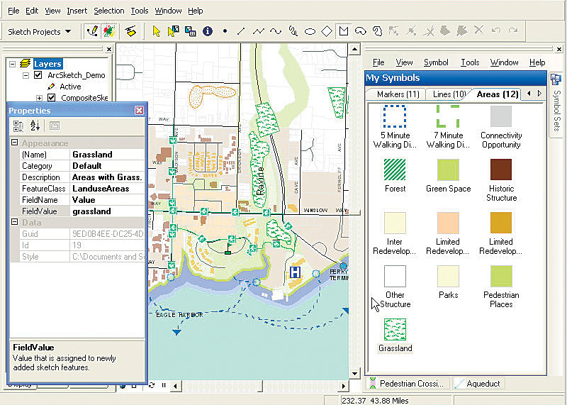
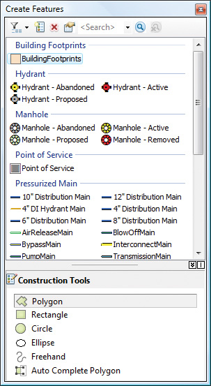
Early Forays in GeoDesignAlthough it might be easy to compare the two, GeoDesign should not be confused with computer-aided design (CAD). In fact, the first geographic design system was ArcCAD, Esri's earliest attempt to build a dedicated GeoDesign tool. Released in the early 1990s, ArcCAD was the first fully functional GIS system within the AutoCAD environment. While traditional CAD is a useful tool in the architectural design of a building, GeoDesign is concerned with designing that same building in and around the environment. ArcCAD was an attempt to integrate geographic data and spatial modeling into the design process. ArcCAD provided powerful mapping, data management, spatial analysis, and display tools that worked directly with AutoCAD's design and drafting tools. ArcCAD was followed by other Esri applications (including SDE CAD Client and ArcGIS for AutoCAD) that allowed designers and others within the CAD environment to leverage the full power of GIS functionality and GIS databases. ArcGIS for AutoCAD, a free downloadable tool that offers seamless interoperability between AutoCAD and the ArcGIS platform, is used widely today. ArcGIS for AutoCAD users are provided with quick and easy access, within the AutoCAD environment, to enterprise GIS data published by ArcGIS Server. This tool lets designers include the results of GIS analysis in AutoCAD designs, as well as create, manipulate, and define how CAD data is organized and attributed as GIS content. Design Tools in ArcGISDesign professionals are creative and rely heavily on intuition, a gut feeling that something is right. GIS professionals providing input to a creative process rely heavily on analysis and science. With GeoDesign, GIS becomes a tool for designers; they can move rapidly through an iterative design process while leveraging the full analytical power of the geodatabase. We believe that bringing together the worlds of design and analysis under one common information system framework will have huge implications. In 2005, Bill Miller, Esri's engineer/architect, led a small team to develop a free sample ArcGIS extension that was the first step toward true GIS-based GeoDesign tools. Released in 2006, the extension allows you to quickly create features in the ArcGIS Desktop ArcMap application with easy-to-use sketch tools. You simply select a sketch tool and an associated symbol, then draw the feature. This simple design tool automatically manages the drawing environment, allowing you to conceptualize what to draw, as opposed to how to draw it. With ArcSketch, you can sketch a set of alternative land-use concept plans, quickly lay out the spatial components of a disaster response plan, sketch out the location of a highway, or lay out a site master plan. As a geographic sketching tool that allows users to sketch initial designs on top of GIS-based maps and imagery, ArcSketch was useful to many of our users, but it is only the beginning. Functionality similar to ArcSketch will be further enhanced and integrated into the core software system at the 9.4 release. And subsequent releases of ArcGIS promise even more support for the use of GIS for design. ArcSketch tool-style editing in ArcGIS 9.4 will make editing simpler, with new streamlined functionality making it easier for you to complete your work. Creating features is accomplished through the use of feature templates. To get started with templates, you just need to start editing, which launches the Create Templates wizard. The wizard will quickly help you build a set of feature templates you can use to create new features. Once you finish, the Create Features window opens with a list of templates.
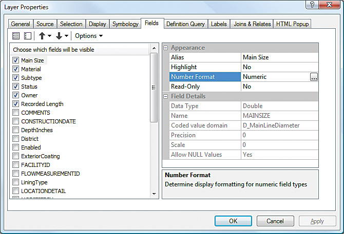
Snapping is now enabled by default and has been broadened from being within an edit session only to being available across ArcMap. To this end, all the settings you need to work with snapping are located on the new Snapping toolbar, including turning on and off snapping types (edge, vertex, endpoint, and so on) and customizing the appearance of the cursor and SnapTips. The Fields tab on the Layer Properties dialog box has been redesigned for 9.4, making it easier to reorder fields, turn them on or off, sort them, and set other display and formatting properties. These properties will be used throughout ArcMap, including the editor's attributes dialog box, table windows, and the Identify dialog box. Meeting the Challenge with GeoDesign
And the need for such tools has never been greater. We live in an ever more complex world, where our impact on the natural environment is massive and can no longer be ignored. People are starting to recognize the importance Neutra placed on the inseparable relationship between humans and nature and to realize McHarg's vision of design with nature, and they want to act. "There is now a growing interest in combining design functionality with the broader geographical context that geospatial tools offer in order to engage more deeply in land-use planning," notes Matt Ball, editor at V1 Magazine. A GeoDesign framework will provide a robust set of tools for design professionals and finally meet the challenge of Ian McHarg, letting us truly design with nature. More InformationFor more information, contact Matt Artz, Esri (e-mail: martz@esri.com). See also "Spatial Concepts in GIS and Design" and GeoDesign. |
 Integration of design tools with existing GIS functionality is important, but it's only the first step. Ultimately, our vision is to expand the utility of GIS to the point that it is a foundational design system. As humanity comes to grips with its overwhelming impact on the natural world, we are also gaining a much better appreciation for our inextricable link to nature. And with that, of course, comes an enormous responsibility—a responsibility made all the more gargantuan by the fact that we still have a long way to go toward fully understanding the dynamics of the various systems and developing a robust suite of comprehensive models and other tools to support these activities. As Neutra did with architecture in the 1950s, we need to advance a framework for design and planning that not just incorporates but also embraces technology; science; and, ultimately, nature in a system that helps us design and choose the best alternative futures.