Summer 2009
Summer 2009 |
|||||||
|
|
|||||||
With GIS, Charity Relieves Suffering in Developing Countries
MapAction Helps Millions of People |
|||||
Highlights
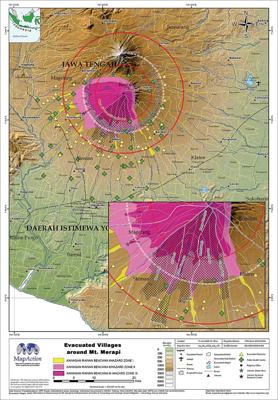
Earthquakes, tsunamis, mudslides, and floods can strike without warning—and the consequences can be devastating. Lives are lost; survivors face immeasurable hardship. International aid organizations respond to these tragedies. However, their work is often hindered by a lack of knowledge about the region they are working in. When a disaster occurs, the landscape changes, sometimes beyond recognition. Villages, roads, and railways may be destroyed; entire hillsides may slip into valleys; and people will be displaced. To address this challenge, one United Kingdom-based charitable organization creates and distributes real-time maps of a disaster zone. Called MapAction, the organization helps governments and relief agencies coordinate aid and relieve human suffering.
A Need for Greater CoordinationAndrew Douglas-Bate remembers where he first witnessed the result of a lack of coordination. He explains: "In 1962, I was living in Tehran and a massive earthquake occurred in southern Iran. The government put out an urgent plea for blankets for the displaced survivors, and the international aid community responded. Many countries sent blankets. The disaster area was soon inundated with them. However, the survivors had many other needs that weren't adequately met. Most of the available money and effort had been focused on sourcing and distributing blankets alone. That lack of international communication, thus the lack of coordination between aid agencies, has stayed with me." Many years later, Douglas-Bate's son Rupert became an aid worker in the former Yugoslavia and Africa. Despite the passage of over 30 years, Rupert Douglas-Bate witnessed the same problems with duplicated and uncoordinated aid that his father had observed many years before he was born. Rupert realized that what was needed was a far higher level of coordination; his idea for this was the genesis of MapAction today. "Problems become more manageable when efficient coordination on the ground occurs," agrees Andrew Douglas-Bate, now chairman of MapAction. "Rupert concluded that the best way to achieve better coordination was through the vehicle of GIS mapping." From this and with the support of a major donor, MapAction was born. The organization was founded by Rupert Douglas-Bate in 1997 and began the long task of fund-raising, training volunteers, creating an organization structure, and purchasing equipment. In 2002, the charity had achieved sufficient funds and structure to appoint a team leader, David Spackman, who strengthened MapAction. An Invaluable, Life-Saving ServiceMapAction knew that rapidly updatable electronic GIS mapping would play a crucial role in its work. After conducting some thorough market research, Spackman selected ArcGIS Desktop solutions, which Esri has been providing since 2003. Esri has provided MapAction with ArcGIS Desktop licenses. MapAction uses GIS to collate diverse datasets, topography, and satellite imagery and to create dedicated, real-time maps of disaster areas. Spackman led MapAction's first major deployment to Sri Lanka following the tsunami that devastated the country in January 2004. A 12-person team stayed in the country for three weeks and created map after map, plotting everything from the locations of food stations to the areas where doctors and medical aid were most urgently required. Then president of Sri Lanka Chandrika Kumaratunga visited the MapAction team to see ArcGIS in action and to personally show her appreciation for the work of the team. Since then, MapAction, often in close cooperation with the United Nations, has carried out more than 15 emergency and 55 disaster preparedness missions. In 2008, a typical year, the charity provided an invaluable service following three major disasters that together changed the lives of more than 4.3 million people. MapAction responded to extensive flooding in Bolivia, producing 76 maps in three weeks and distributing over 2,000 copies to government and relief workers. MapAction deployed a team to help deal with the consequences of Cyclone Nargis in Myanmar. It distributed over 3,000 maps and worked closely with the charity Save the Children to help track its relief aid program throughout the devastated region. MapAction also deployed a team to Haiti where more than 900,000 people were affected by hurricanes and tropical storms. In these ways—and others—MapAction helps save lives. A Rapid Response to Disaster
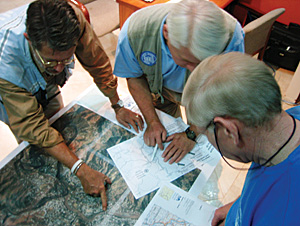
MapAction team members, all highly trained volunteers, give their time and skills free of charge. The organization currently has over 70 volunteers, around 30 of whom are deployable at a moment's notice. Several employees from Esri (UK) Ltd., Esri's distributor in the UK, are actively involved in the charity. The majority of volunteers have GIS skills, but others have complementary operational or medical capabilities. Most importantly, the volunteers all have the right personal attitude and character to cope in very traumatic and challenging circumstances. One of the primary goals of MapAction is to provide a quick response. "The first few hours of any disaster are absolutely crucial; this is when lives can be saved," says Rupert Douglas-Bate. MapAction receives an alert about a major incident, usually within an hour of it occurring. Spackman and the headquarters team immediately put volunteers on standby and begin to amass for the region as much GIS-based map data as possible. When the call to deploy comes, often from the United Nations, a team can usually be dispatched in a matter of hours. On arrival in a disaster zone, MapAction volunteers, equipped with state-of-the-art GPS units, a satellite link, and communications equipment, survey the area and mark the locations of accessible paths, bridges that are still standing, and other waypoint landmarks. They collect situational information from any reliable source and plot it on accurate maps of the area using ArcGIS Desktop software and laptop computers. As the crisis unfolds and new information becomes available, maps are updated in real time and distributed to other aid agencies both electronically and as hard copies. In the future, MapAction plans to make use of ArcGIS Server to increase the efficiency of rapid mapping and to facilitate interoperation with other GIS-equipped agencies in the humanitarian sector. An Ambassador for GISAs a charitable organization, MapAction is dependent on donations to enable it to provide its free-of-charge service to developing countries. The organization has received support in kind and cash from many sources: other charities, corporate sponsors, and members of the public. "When a crisis occurs, donations follow," says Andrew Douglas-Bate, "but we need funds year-round so that we can train our volunteers, keep up-to-date with technology, and at all times be ready to deploy. David Spackman, our CEO, and Nigel Woof, our operations director, have brought to MapAction a strong organizational structure and clear processes that enable us to operate both effectively and cost efficiently. We have a small, lean headquarters; sophisticated storage and maintenance; and just two full-time and four part-time employees. As a result, MapAction is able to ensure that funding goes directly to where it is needed. Every financial gift really makes a difference to people in need." Between major humanitarian crises, MapAction offers its services to the humanitarian community, thus helping it to help itself, in the use of GIS. These skills-transfer projects allow MapAction to play an important secondary role in promoting the benefits of GIS worldwide. In the words of Rupert Douglas-Bate, "MapAction is a good ambassador for GIS." More InformationFor more information, contact Nigel Woof, operations director, MapAction (e-mail: nwoof@mapaction.org), or visit www.MapAction.org. |