Summer 2009
Summer 2009 |
|||||||
|
|
|||||||
Young Explorers Study an Unmapped Region of the Himalayas
Students Scale New Heights with GIS |
|||||
Highlights
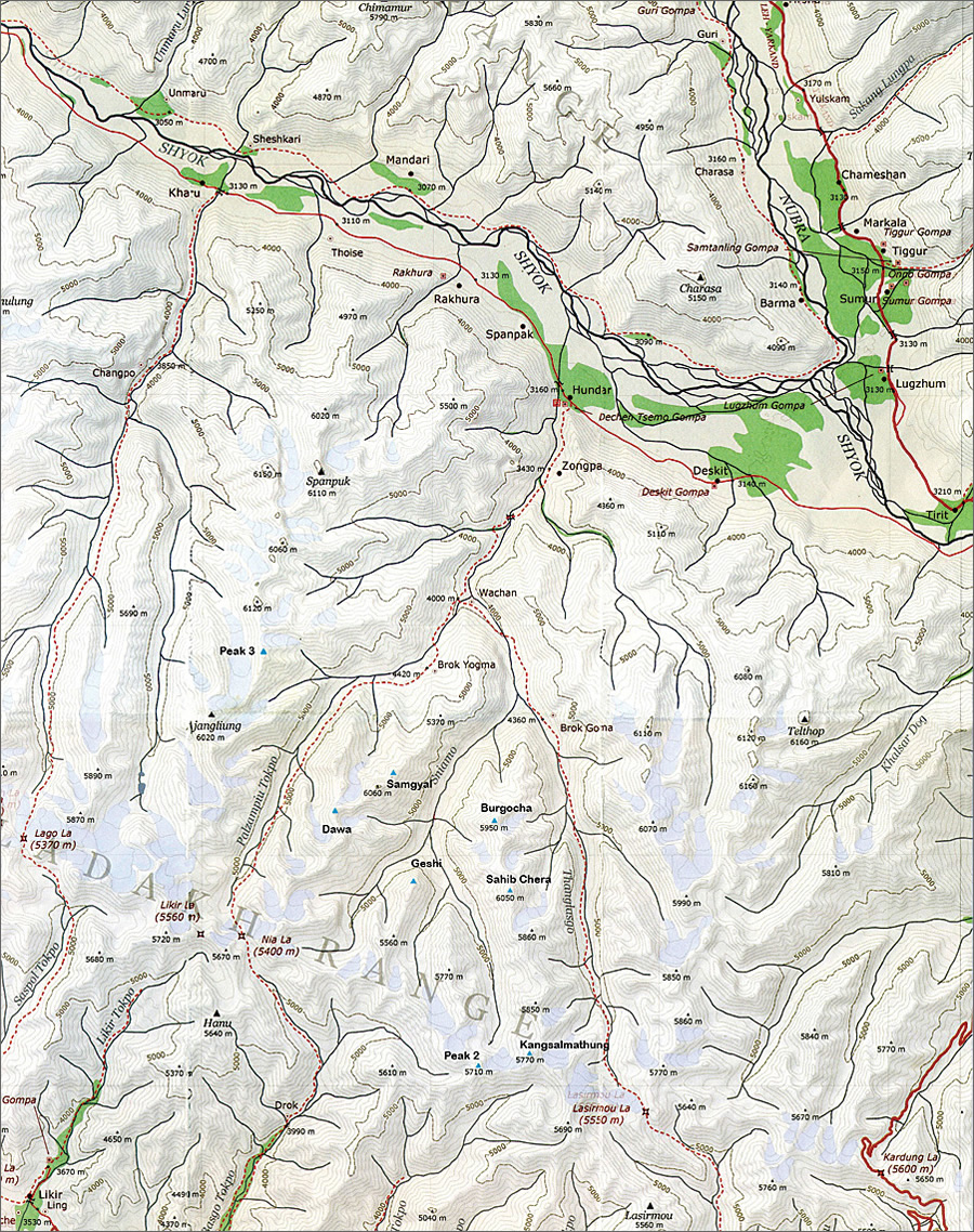
Thirty-eight British students have named mountains for a new mountaineering and trekking guide for the remote and semidesert Ladakh region of the Himalayas. Ladakh is regarded as the "land of high passes." It is a region in the Indian state of Jammu and Kashmir between the Kunlun mountain range in the north and the main Great Himalayas to the south.
Computer-based mapping of this remote region using GIS in the field underpinned the core purpose of a challenging monthlong research expedition organized by the British Schools Exploring Society (BSES) in July�August 2008 for British students aged 16�20. Maps of the Ladakh region had previously been unavailable. BSES is a nonprofit United Kingdom-based charity, established at the Royal Geographical Society in London, which has been providing opportunities since 1932 for young people to take part in adventurous expeditions that involve environmental science research in wilderness areas. Aims of the Ladakh ExpeditionCreating and interpreting mapping and geospatial data supported the expedition's two aims—scientific outputs and adventure activities. The Young Explorers (YEs) were able to combine the excitement of climbing in an unmapped region of Ladakh while researching their environment and analyzing findings on digital maps in GIS. The Hundar peak, for example, has no previously recorded ascents and was summited by the BSES team in August 2008. The students ran ArcGIS Desktop software on laptops provided by Esri (UK) Ltd., Esri's distributor in the UK, to log and analyze geographic data. Matt Bridgestock, BSES Ladakh expedition leader, says, "The main Thanglasgo Valley in Ladakh has become well known to hikers, but the area beyond it had been uncharted territory until the students used GIS. One of the peaks in the northern valley and two in the southern valley had never been ascended before the group arrived. The students were able to plot mountains on maps and name them. Everyone had a fantastic time on what was a dream expedition." The resultant mountaineering and trekking guide of Ladakh is available as a PDF on the BSES Web site (www.bses.org.uk), containing maps generated by ArcGIS. Botanical Projects
As part of the expedition, the students also engaged in science and botanical projects using ArcGIS to identify and analyze the distribution of plant species in the Thanglasgo Valley and side valleys. No one has ever recorded plant species in these valleys, so the YEs initiated a species list for the region and sampled the vegetation at 200-meter intervals between 4,200 meters and 5,200 meters (approximately 14,000�17,000 feet). GIS was used to enter distribution data in the field and will be built on to show graphs of plant distribution. This will provide a baseline measure for recording the response of these species to climate change. As global temperatures increase, it has been predicted that plant species in mountainous areas will shift their altitudinal ranges upward. More InformationFor more information, contact Charlie Masding, BSES Expeditions, Royal Geographical Society (e-mail: charlie@bses.org.uk, tel.: 020-7591-3141), or Ruth Adams, Esri (UK) Ltd. (e-mail: radams@esriuk.com). |