Summer 2009
Summer 2009 |
|||||||
|
|
|||||||
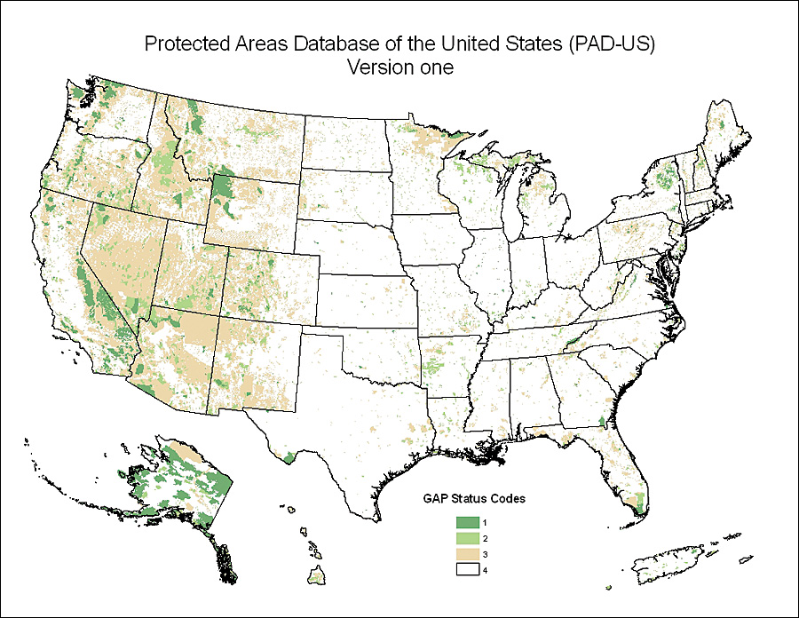
USGS GAP Partnership Develops Protected Areas Database |
||||
Highlights
A public-private planning consortium of conservation organizations has joined forces to address this issue with the development of the Protected Areas Database of the United States (PAD-US). Key partners in the effort are the Bureau of Land Management, the Conservation Biology Institute (CBI), the GreenInfo Network, The Nature Conservancy (TNC), the U.S. Forest Service, and the U.S. Geological Survey (USGS) Gap Analysis Program (GAP). The long-term vision of the group, which was funded by USGS and the Doris Duke Charitable Foundation, is to provide the guidance and infrastructure necessary to maintain protected lands data with greater accuracy and detail than previously possible.
PAD-US, released in April 2009, generally describes protected lands as those lands held in fee or easement ownership for permanent or very long-term open space uses. These include national parks and forests, public lands, wildlife preserves, state and local parks and reserves, wildlife management areas, lands held by nonprofit organizations, and other areas designated as protected. The database, built in an ArcGIS file geodatabase, provides a wealth of attributes, including the name, location, ownership, land management designation, and measures of biodiversity protection, for each parcel in the dataset. GAP has long used ArcGIS to map land cover, land stewardship, and predicted vertebrate species distributions—first on a state-by-state basis and more recently on a regional basis. In addition to providing a comprehensive picture of conservation lands in the United States, GAP has worked with the United Nations Environment Programme World Conservation Monitoring Centre (UNEP-WCMC) to link PAD-US to the World Database on Protected Areas (WDPA). To enable inclusion of PAD-US in the WDPA, International Union for Conservation of Nature classification designations were applied to each parcel in the database. This linkage will facilitate collaboration between conservation organizations by establishing a consistent understanding of protected lands status whether the focus is global or local. "The U.S. data is extremely important to us," says Charles Besan�on, head of Protected Areas Programme, UNEP-WCMC. "Integrating PAD-US and WDPA is a high priority." The UNEP-WCMC Protected Areas Data Unit, which maintains the WDPA, was established in 1981 to compile information on the world's protected areas and to be a resource for those requiring such information. Because it incorporates information from national governments, nongovernmental organizations, academic institutions, international biodiversity convention secretariats, and other organizations in each country into a single dataset, the WDPA is an important resource for the organizations and individuals making decisions about conservation. BackgroundTo create the stewardship layer, GAP aggregates public landownership and internal management boundaries and categorizes protected areas on a scale from 1 to 4 based on their conservation management practices. Prior to 2008, GAP focused on state and regional projects, creating the need for a national protected areas database that CBI initiated, with funding from sources such as the World Wildlife Fund and USGS GAP. CBI and GAP continued to manage data at different scales until it became apparent that a variety of stakeholders was required to provide the sustainable resources needed to meet demand, resulting in the initiation of the PAD-US design process. The PAD-US project is addressing some long-term maintenance issues with protected land inventories. Partners are working to extend aggregations to local (easement parcel, city, county) levels, build capacity for improved/automated state data updates, and increase efficiency through more coordinated federal land inventories. The partnership will facilitate the maintenance of a national dataset by improving the spatial accuracy of inventoried lands and creating a standard for collecting and processing the data. The partnership has developed a uniform coding system that specifically categorizes the protection level for each parcel contained in the database and has developed more complete and descriptive attributions for the data. Finally, protected areas are both uniquely and uniformly identified by name and management designation to facilitate assessments at various scales (regional, continental, and global). The geodatabase was a natural choice for creating and hosting PAD-US, which incorporates disparate data from numerous partners. Using a geodatabase made the integration of more than 800,000 records from hundreds of different organizations feasible. "It was challenging to design a user-friendly and accurate parcel identification system," says Lisa Audin, GAP stewardship coordinator. "Data sources provided an incredible variety of landownership and management designation descriptions, complete with spelling errors and various acronym combinations." The use of coded domains in the PAD-US geodatabase was pivotal to standardizing a parcel's class (federal, tribal, state, private, etc.), land manager (U.S. Forest Service, State Fish and Game, TNC, etc.), and management designation (wild and scenic river, wilderness area, national wildlife refuge) in a national context. The complex nature of protected land data required a robust, yet flexible, geospatial database structure. The PAD-US technical team determined that Esri's geodatabase technology offered the tools required to manage the spatial and tabular complexity inherent in the data. For example, the complexities of multiple designations for a single piece of land will no longer need to be handled in a limited fashion with the attributes table (Designation_1, Designation_2, etc.) but can be represented as separate but overlapping feature classes with associated topology rules. The final geodatabase reflects the efforts of the year-old PAD-US partnership to increase collaboration among organizations and share resources. Due to this partnership, it is now possible to envision a mutually agreed-upon set of land and land-use classifications that incorporates public lands, as well as available data on privately protected lands such as easements held by land trusts and others. However, such privately protected lands information will be developed cautiously, so as not to violate any privacy concerns. By providing a comprehensive picture of protected lands, PAD-US data will help conservation decision makers develop a clearer understanding of how the combined efforts of public and private landowners have contributed to the conservation of wildlife and habitats across the country. More InformationFor more information, contact Lisa Audin, stewardship coordinator, USGS Gap Analysis Program, University of Idaho (e-mail: laudin@uidaho.edu), or visit gapanalysis.nbii.gov. |