Summer 2010
Summer 2010 |
|||||||
|
|
|||||||
Navigate Maps, Capture and Report Data, and Perform GIS Analysis
ArcGIS for iPhone |
|||
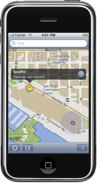
Esri has expanded its mobile GIS platform to support the iPhone. ArcGIS for iPhone will include both a free downloadable application from Apple's App Store and an API for iPhone developers to build focused mapping solutions. ArcGIS for iPhone leverages capabilities from ArcGIS Online to provide a seamless and easy user experience. Users can navigate maps and discover assets from Web services, as well as capture new data from the field and send information back to the server. This allows ArcGIS Server customers to leverage their GIS investment in the iPhone by using the device to access their own corporate data. ArcGIS for iPhone also promotes collaboration and information sharing between multiple users in the field. For example, field users can create and share status updates with others to communicate and work more efficiently. ArcGIS Application for iPhoneArcGIS for iPhone is a native iPhone application that serves as a mobile gateway into the ArcGIS system. This system will include access to services available through ArcGIS Online or on-site ArcGIS Server deployments hosting your corporate authoritative data. The ArcGIS for iPhone application consumes maps authored and hosted through ArcGIS Server. These maps contain not only data but also functionality (query, find, geoprocessing tasks, etc.). The ArcGIS for iPhone application includes the following capabilities:
ArcGIS API for iPhoneThe ArcGIS API for iPhone is built on Objective-C/Cocoa, the development framework for iPhone. It provides developers and Esri partners with the opportunity to create their own custom, spatially enabled iPhone applications to address their end-user and business requirements. It also lets organizations extend their solution products to iPhone's large user base and brand their iPhone applications with a custom logo, look and feel, etc. The API is designed to work with and use Web services available from ArcGIS Server and ArcGIS Online, and its architecture is similar to Esri's ArcGIS Web Mapping APIs for JavaScript, Flex, and Silverlight. It will also follow the same ArcGIS API release and deployment pattern: easy online access/download with periodic updates. Developers and Esri partners will use the API to create their own applications for both external and internal use. They can also easily build iPhone applications that work with their own published Web services. The beta version of the API is available from the iPhone Resource Center and includes
More InformationTo learn more, visit www.esri.com/arcgisforiphone. |