Summer 2010
Summer 2010 |
|||||||
|
|
|||||||
ArcGIS 10 Simplifies GIS Workflows |
|||
|
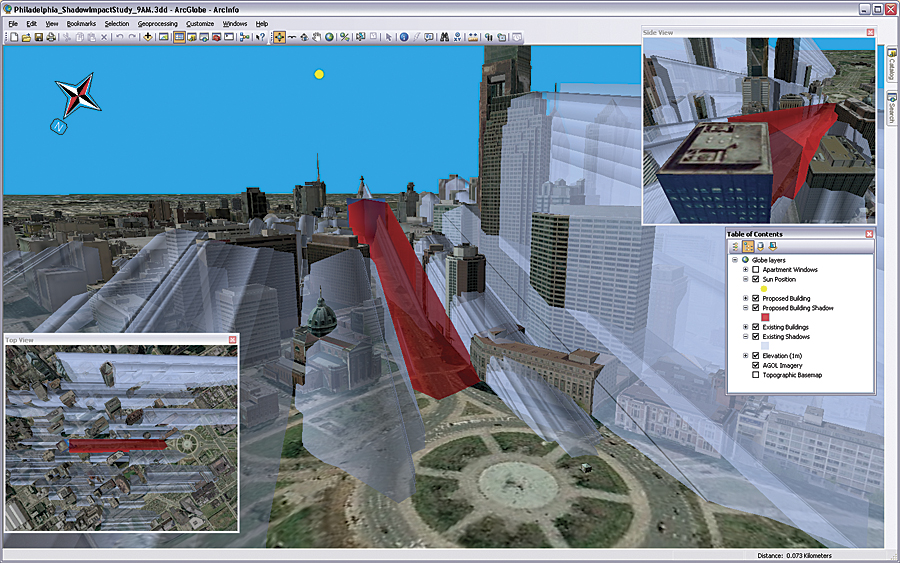
GIS professionals can now take advantage of a host of tools and other enhancements that simplify their work. Improvements to ArcGIS that range from making it easy to add basemaps to ArcGIS Desktop projects to automating map production and performing spatial analysis more efficiently, as well as tools for collaborating with others, are just a few of the features of this release. Improvements to Productivity
New productivity tools to support the workflows of GIS professionals enhance the whole ArcGIS user experience. This release makes map creation and production much easier and provides best practices templates to help users get started quickly. Users can search by keywords or data types to find data and maps. They can also use the search function to quickly and easily find symbols to use in their maps and tools for analysis. Editing in ArcGIS 10 is streamlined; this release introduces sketch-based desktop and Web editing, which means that users can choose from a customizable on-screen palette of features in desktop and Web clients. In addition to making users more efficient, this new editing experience allows the expansion of volunteered geographic information or user-generated content on the Web. Users will notice faster performance, which is the result of averaging local graphics cards on desktops and improved cache generation and management, as well as optimized Web graphics. These caching and Web graphic improvements translate into more responsive drawing performance, including smooth, continuous panning of data. Online ContentAn exciting aspect of ArcGIS 10 is that users can leverage online maps and tools that are a built-in part of their ArcGIS experience—this includes ArcGIS Desktop; mobile devices, such as smartphones; browsers; and applications developed using ArcGIS Web Mapping. For example, with the click of a button, ArcGIS Desktop users can add a visually pleasing basemap to their projects. Also, users can find, share, organize, and use maps, apps, and other resources via the new ArcGIS.com site—a Web-based gateway into the ArcGIS system. Furthermore, users can discover, share, and present geographic information using ArcGIS Explorer Online, a new browser-based version of ArcGIS Explorer. Cloud DeploymentArcGIS Server can now be used from the Amazon cloud. Running ArcGIS Server on Amazon allows organizations to take advantage of multiple cloud services and features. These include the ability to deploy ArcGIS Server across more than one data center and access to Amazon's elastic computing infrastructure, which makes it possible for organizations to quickly adjust the capacity of ArcGIS Server services and applications to user demand. Powerful Spatial AnalysisThe notion of time is now built into the data management visualization and analysis aspects of the software. Users can create, manage, and visualize time-aware data. They can also display and animate temporal datasets, as well as publish and query temporal map services. The ability to see data over time opens opportunities for more in-depth analysis. It is now much easier and faster to perform 3D visualization on the local machine. In fact, at this release, ArcGIS becomes a full 3D GIS, offering 3D data models, editing, analysis, and visualization on the local machine. As a result, users can do virtually everything they do in a 2D environment in a 3D environment. Also with this release, Esri continues to advance geographic science with new tools. ArcGIS 10 includes Python scripting for automating common tasks and analyses. Using Python, the capabilities of ArcGIS can be combined with other scientific programming to create powerful solutions. Among the new analysis capabilities offered in ArcGIS 10 is location-allocation, which helps users understand how their facilities' placements in a given network impact their ability to serve their customers. New Ways to ShareTight integration with ArcGIS online searching and sharing capabilities makes it easy to create and distribute projects that may include data, layers, maps, tools, scenes, globes, diagrams, and add-ins. It is also easy to discover and organize geographic data throughout the enterprise via the new Search service in ArcGIS Server. ArcGIS 10 also enables feature-level editing via Web applications. Improved Access to ImageryThe use and management of imagery are now more efficient on the desktop and the server. Users can experience faster performance with accelerated image display, and they can save time by using the image analysis window for image interpretation and processing. It is also easy to manage massive image collections with dynamic mosaicking and on-the-fly processing. Users can efficiently serve dynamic image mosaics to many applications. More Flexible DeploymentArcGIS Desktop licenses are now much easier to install and manage. Users can borrow ArcGIS Desktop licenses for temporary use away from the office (e.g., field units, work from home, business travel). Also, as mentioned above, users can extend ArcGIS use to the Amazon cloud. This is done through flexible Amazon Machine Image (AMI) hosting capabilities. Expanded GIS in the FieldThe new Mobile Project Center simplifies ArcGIS Mobile deployments. Also, users can now leverage streaming GPS, photo attachments, and location tracking. ArcGIS Mobile has a customizable, ready-to-deploy application that allows users to extend mobile projects to in-vehicle and tablet-based PCs. Also, soon customers will be able to download the new ArcGIS for iPhone mapping application directly from the Apple iTunes App Store. In addition, Esri is providing an ArcGIS for iPhone Software Development Kit (SDK) so organizations can build their own focused iPhone applications. Better for DevelopersDevelopers can also take advantage of the simplified experience that ArcGIS now offers. They can use add-ins, which are easy to share and deploy, or Python to extend their desktop applications. They can also easily build applications with additional Web APIs and streamlined software developer kits. There is now a single ArcObjects .NET SDK as well as a single ArcObjects—Java SDK for ArcGIS Desktop, ArcGIS Engine, and ArcGIS Server. More InformationTo find out more about ArcGIS 10, visit www.esri.com/whatsnew. |