| |
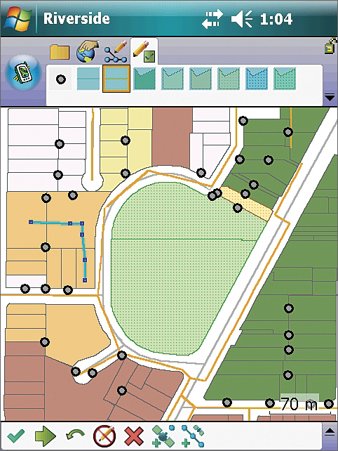
The new, dynamic QuickCapture toolbar in ArcPad 10 lets users quickly capture new features with a single tool selection. |
ArcPad, a feature-rich mobile GIS application for field mapping and data collection, incorporates new features and quality improvements in the latest version, ArcPad 10.
Now in its tenth year, ArcPad continues to build on enhancements made in Esri's previous release, ArcPad 8. ArcPad 10 improves field productivity and helps users manage their GIS projects more efficiently.
ArcPad includes advanced tools for finding, creating, and updating GIS information. ArcGIS Desktop provides checkout and check-in management of ArcPad data and maps, while the ArcGIS Server ArcPad extension can be used to synchronize edits back to the enterprise geodatabase directly from the field.
ArcPad Studio, which was included in core ArcPad software at version 8, is the development framework to create projects tailored to an organization's specific workflows by using customized tools and add-ins.
New features include
- Support for ArcGIS Online Map Services—Access ArcGIS online basemaps, such as World Street Map, World Topographic Map, and World Imagery, as well as Bing Maps, that can be used in ArcPad projects.
- Improved Performance—Drawing speed has increased from the previous release. Improvements have also been made to Esri StreetMap Premium to ensure the maximum amount of memory is available to both ArcPad and StreetMap Premium, ensuring better performance for users.
- Dynamic QuickCapture Toolbar—Quickly capture new features with a simple tap-on screen. The QuickCapture toolbar contains tools representing features in the user's current map that the user can choose to create new features. This toolbar requires no customization and can be used across all the user's ArcPad projects.
 Enhanced ArcPad Data Manager for ArcGIS—More opportunity exists to customize an ArcPad project with no coding or scripting needed. Data entry forms are generated for related tables, and users have greater control over using photos in ArcPad projects. Hyperlinked photos are now integrated in the checkout and check-in processes. Enhanced ArcPad Data Manager for ArcGIS—More opportunity exists to customize an ArcPad project with no coding or scripting needed. Data entry forms are generated for related tables, and users have greater control over using photos in ArcPad projects. Hyperlinked photos are now integrated in the checkout and check-in processes.- Better Camera and Photo Experience—A new camera module that works for a greater number and range of hardware devices will benefit ArcPad 10 users. Across a variety of devices, the camera's user experience is the same. Along with improved photo management (within the ArcPad Data Manager), users will be able to incorporate photos into their ArcPad projects much easier and faster.
More Information
For more information on what's new in ArcPad or to evaluate ArcPad at no cost, visit www.esri.com/arcpad.
|