Summer 2010
Summer 2010 |
|||||||
|
|
|||||||
GeoSUR Opens Geographic Information for Use Throughout South America
Collaboration Through GIS and a Regional SDI |
|||||
Highlights
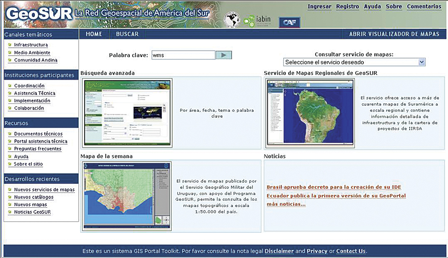
Sustainable development means meeting the needs of the present while preserving the environment for future generations. Creating an economy in a country that is in tune with basic ecological support systems doesn't stop at country borders. Rivers traverse borders, roads must connect various cities, and forests transcend country boundaries. South America, with its bountiful natural resources, will benefit from a collaborative effort to manage its many precious resources and maintain healthy living conditions for its people. "There is a need in South America to make important development decisions—decisions that impact the lives of thousands, sometimes millions of people—using sound and accurate scientific information," says Eric van Praag, regional coordinator of the GeoSUR Program. "Much of this information can be expressed geographically and can be put into formats and represented in ways that decision makers understand and can readily use." Ensuring that geographic information is readily available is the mission of the GeoSUR Program, a regional initiative to integrate and disseminate spatial data in South America. GeoSUR was originally developed under the aegis of the Initiative for the Integration of Regional Infrastructure in South America (IIRSA), which promotes the development of transportation, energy, and telecommunications infrastructure from a regional viewpoint. Since the program's inception in 2007, GeoSUR has grown to serve a large audience interested in development objectives, both regionally and within individual countries. GeoSUR has three main components: a geoportal, a network of map services, and a regional topographic processing service. GeoSUR Portal Makes Updating and Finding Spatial Data Easier
GeoSUR has developed, with support from the U.S. Geological Survey (USGS) Earth Resources Observation and Science (EROS) Center, the first regional portal providing access to geographic data and services from all South American countries (www.geosur.info). Launched in October 2009, it provides a point of entry to the map services and metadata catalogs operated by GeoSUR's partner agencies. GeoSUR chose the ArcGIS Server Geoportal extension software to build the portal because it provides an efficient platform to integrate the diverse and changing geospatial resources located throughout the region. The regional portal provides access to the metadata holdings of all the participating agencies. It keeps a central metadata database that is periodically updated by an automatic harvesting mechanism that fetches metadata from the participating agency's catalogs. The portal also contains a map viewer that allows the user to retrieve, open, and view layers available in partner map services. The network architecture is decentralized to keep the data updated and close to its producers. Currently, there are more than 20 map services linked to the portal and more than 3,000 metadata records available on its database. Network of Regional and National Map ServicesA great variety of national and regional spatial data is available through GeoSUR, including political-administrative divisions, soils, topography, ecosystems, hydrography, biodiversity, water bodies, geology, cities and towns, elevation models, land cover, aerial photos, ecological regions, satellite imagery, and infrastructure. This information is available through a decentralized network of map services currently being created by the GeoSUR participating agencies, with each agency committing to the development of a Web Map Service (WMS) and a metadata catalog. Once a map service is developed, the map service administrator creates an ISO 19119 metadata record for it and registers it on the GeoSUR portal for public viewing. GeoSUR emphasizes the use of recognized Open Geospatial Consortium, Inc. (OGC), and International Organization for Standardization (ISO) standards and protocols to reach interoperability of its various geoservices. Participating agencies have the liberty of choosing the hardware and software platforms for sharing data with the network, provided they use regionally recognized standards. Most map services in the network contain geographic data at the national level, but there are two regional services available today: the GeoSUR Regional Map Service and the Condor Service. The GeoSUR Regional Map Service is geared toward infrastructure developers, offering access to spatial data on existing IIRSA and Andean Development Bank (CAF) infrastructure projects and on themes that impact infrastructure development, such as roads, ports, airports, railroads, oil pipes, rivers, protected areas, land use and land cover, and topographic relief. The service was developed with the support of the EROS Center using ArcGIS Server. All regional data in the service is available for download at no cost. The Condor Service allows visitors to view environmental data of the Andean countries useful for planning infrastructure projects. The service includes an early assessment tool focused on identifying environmental risks and opportunities for projects in the planning phase. The Condor map viewer is available at esriurl.com/c3. On-the-Fly Topographic Processing ServiceGeoSUR offers a Topographic Processing Service (TPS), the first of its kind in the developing world that provides access to digital elevation model (DEM)-derivative products that can be generated on the fly for any location in South America. Users can run the service models using an assorted set of DEMs at different resolutions, including 1 kilometer, 90 meters, and 30 meters. The available TPS models include elevation profile, slope classification, dynamic watershed delineation, hillshade, elevation classification, aspect, and raindrop trace. The service is part of the GeoSUR Regional Map Service, available at the GeoSUR portal (www.geosur.info). All TPS-derived data can be downloaded free of cost. Before launching the service, the USGS EROS Center filled the voids in the Shuttle Radar Topography Mission (SRTM) 30-meter dataset for South America with Advanced Spaceborne Thermal Emission and Reflection Radiometer (ASTER) GDEM and GTOPO30 data and created a set of seamless derived datasets that include hillshade, shaded relief, slope, and aspect for the region. Advanced users can directly access these models from ArcGIS Desktop by accessing the TPS GIS geoprocessing service. From within ArcMap, local data can be used with this service to more precisely extract the derivative products and simply integrate them into the application. To further streamline the TPS service, users can integrate them in local ModelBuilder applications and Python scripts. "Important development decisions are often taken without the proper use of geographic information and modeling techniques that are now becoming widely available," says Santiago Borrero, secretary general of the Panamerican Institute of Geography and History (PAIGH). GeoSUR: An Eye on Spatial Data for South AmericaGeoSUR is coordinated by CAF and PAIGH, with technical assistance from the USGS EROS Center and the national mapping agencies of Colombia, Chile, and Ecuador. Participating agencies include, but are not limited to, national geographic institutes and national environmental agencies from the region. In total, more than 22 national agencies have agreed to participate in the GeoSUR Program, with more expected to join. GeoSUR provides training and technical assistance to all partner agencies as they develop the map services and metadata catalogs to be linked to the GeoSUR Geoportal and the Regional Map Service. GeoSUR specialists are on call to offer technical assistance that agencies may need, both remotely and on-site. GeoSUR also sponsors peer-to-peer communications among participating specialists. More InformationFor more information, contact Eric van Praag, regional coordinator, GeoSUR Program (tel.: 58-212-209-6554, e-mail: evanpraag@caf.com), or visit www.geosur.info. |