Summer 2010
Summer 2010 |
|||||||
|
|
|||||||
State of Hawaii Deploys Web-Based Flood Hazard Assessment Tool
Digital Flood Insurance Rate Maps Are GIS Ready |
|||
Highlights
When most people think of Hawaii, they imagine a paradise of beautiful beaches, big waves, and glorious sunsets. They may also think of the lush vegetation and diverse wildlife. What most people don't know is that Hawaii is also among the wettest places on earth with an average annual rainfall total of more than 60 inches. While the majority of this rainfall runs off harmlessly into the ocean, flooding in developed areas is an everyday risk. In fact, flooding is the number one natural disaster in the United States. To proactively assess and address flooding risks to the public, the U.S. Federal Emergency Management Agency (FEMA) has developed the National Flood Insurance Program (NFIP). This program was created by Congress in 1968 to help provide a means for property owners holding federally backed mortgages to financially protect themselves in the event of a flood. Flood insurance is mandatory if you live in a high-risk area and have a mortgage from a federally regulated or insured lender. The NFIP offers and regulates coverage and costs to those affected property owners in communities that participate in the program. In return, the participating community agrees to adopt and enforce ordinances that meet or exceed FEMA requirements to reduce the risk of flooding. In Hawaii, all four defined communities, which align with the four counties in the state, participate in the program.
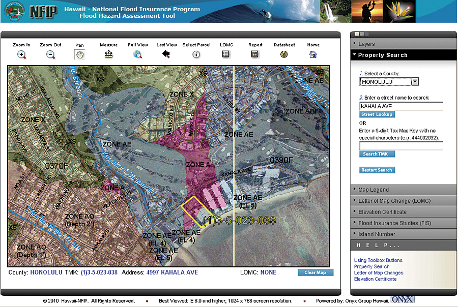
To identify a community's flood risk, FEMA conducts a Flood Insurance Study. The study includes statistical data for river flow, storm tides, hydrologic/hydraulic analyses, and rainfall and topographic surveys. FEMA uses this data to create the flood hazard maps that outline the community's flood risk areas. These flood hazard maps delineate the flood zone classifications ranging from low to high risk. In 2004, FEMA began a nationwide map modernization process to digitize these flood hazard maps into GIS-ready Digital Flood Insurance Rate Maps (DFIRMs). The objective of this process was to provide a more powerful tool for flood risk management, insurance activities, and disaster operations. End users can now integrate accurate and timely local data with FEMA flood hazard data to support their work in the NFIP and take advantage of technology to streamline processes. For Carol Tyau-Beam, the State of Hawaii NFIP coordinator, this was the opportunity to utilize this data in a much more effective and efficient manner. "With the development of the DFIRMs," she says, "we knew we could get much more out of the maps than previously. We are a small state composed of just four communities, but with hundreds of miles of shoreline and so much development in these areas, accurate flood maps are critical for the decision-making process." Tyau-Beam worked closely with the FEMA-operated Map Service Center to download the DFIRM databases by community as they became available. While the data was available in multiple formats, FEMA selected the Esri shapefile format due to its compatibility with the existing data available throughout the state. This provided the required baseline data, however, only at the desktop and only for two of the four communities statewide. Given the magnitude of the map modernization process, not all communities in Hawaii had come online with DFIRM data at the same time. Initially, only two of the four communities in Hawaii had the DFIRM data designated as effective. Tyau-Beam had become familiar with a local Esri partner, the Onyx Group, through the local Esri user group community. She had seen a presentation at a user group meeting where a solution was presented that was very similar to her situation. She says, "They presented the opportunities to develop a Web-based application that would be easy for the public to use while providing the sophistication to provide accurate and effective maps." Development of the initial application, dubbed the Flood Hazard Assessment Tool (FHAT), began in 2007. DFIRM data was collected where applicable, as was aerial imagery and parcel and road network layers from the Hawaii statewide GIS program. With the abundance of data available in shapefile format, the decision was straightforward to develop the application using ArcGIS Server for the .NET Framework. Functional requirements were developed through an iterative process. The team knew the tool needed to be as simple to use as possible, since it was intended for public use. That meant removing some of the typical GIS functionality and minimizing the buttons and tools on the screen. An ArcGIS Desktop map document file (.mxd) was developed that combined the required feature, raster, and data layers and set the appropriate symbology. The team then created an ArcGIS Server map service from the .mxd file and integrated it into the Web application. The resultant tool was a completely customized solution designed specifically for a wide range of public users. ArcGIS Server handles the mapping requests and responses, while traditional .NET Framework controls handle the remainder of the tasks. The initial FHAT application was rolled out on January 1, 2008 (gis.hawaiinfip.org/FHAT). It included the ability for users to locate their property by one of three ways: location, street address, or tax map key. DFIRM data was included for Kauai and Honolulu counties, with georeferenced raster .tif files deployed for Maui and Hawaii counties. The tool was promoted statewide as a valuable resource for obtaining current flood hazard data. Tyau-Beam scheduled a series of presentations to local stakeholders, including the planning and design community, as well as insurance professionals and real estate organizations. As soon as the initial tool was rolled out, the development team immediately saw the potential of additional functionality and data. Tyau-Beam notes, "We saw that we could use the tool not only to disseminate effective flood maps, but we could also use it for public review of preliminary maps." Over the next two years, other layer additions included incorporation of Letters of Map Change, NGS benchmarks, and stream cross sections. These layers added information to the tool and allowed even more detailed assessment. A reporting capability was included to generate a hazard assessment report on a property. The team also added preliminary DFIRM maps for Maui and Hawaii counties to allow the public to review these maps online and provide comment. Specifically, second generation preliminary DFIRM maps for Honolulu and Kauai counties were added to the FHAT to allow users to overlay these on the effective DFIRMs for quick and easy comparison of the two. A link was added to allow comments on these preliminary layers to be submitted directly from the map. Because the framework of the FHAT had been developed in a modular fashion, these additions proved to be simple and straightforward to implement. Today the system continues to evolve, most recently with the incorporation of an Elevation Certificate (EC) tool. An EC form is required for the permitting process on a property in a special flood hazard area. This tool allows applicants or surveyors to initiate an EC for a property directly from the FHAT. The EC tool uses GIS attribute data extracted from the search query to generate a partially completed PDF form. The user can then download the partially completed form to finish filling it out and save and submit it electronically. More InformationFor more information on the State of Hawaii FHAT, contact Carol Tyau-Beam, state NFIP coordinator (e-mail: Carol.L.Tyau@hawaii.gov); for technical information, contact Steve Lettau, the Onyx Group project manager (e-mail: slettau@onyxgroup.com). |