Summer 2010
Summer 2010 |
|||||||
|
|
|||||||
A Hong Kong Experience of Citizen Engagement in Public Affairs
GIS Applied in E-engagement |
|||||
Highlights
Web 2.0 has caused a paradigm shift in the way we communicate and share information on the Internet with the proliferation of Web applications, such as social networking sites, blogs, chat rooms, and video-sharing sites. Governments and many public service organizations have captured the essence of Web 2.0 and integrated it into their current infrastructures, which are enhanced to offer more effective and timely services to their citizens. The Washington State Department of Transportation (United States) has pioneered the use of Twitter to deliver traffic information and updates. Its use of social networking technologies has facilitated timely dissemination of useful information across different communities. Similarly, Chinese Premier Wen Jiabao also tapped the intelligence of Web 2.0 technology to exchange dialogs with Internet users via two national news portals, www.gov.cn of the central government and www.xinhuanet.com of the Xinhua News Agency, in February of this year. GIS Combined with Web 2.0 Engages Hong Kong Citizens in Community AffairsEngaging community involvement is at the heart of the Web 2.0 concept. Combined with GIS, Web 2.0 technologies present users with added convenience in the global village. Dr. Winnie Tang, CEO of Esri China (Hong Kong) Limited, as well as a district councillor of the Hong Kong Special Administrative Region government, made the first attempt in Hong Kong to use "crowdsourcing" via her personal Web site www.winnietang.hk. The built-in functions of the site help raise public awareness of information and communication technology (ICT)-related community affairs and encourage public sharing of opinions through the online platform. Hong Kong, also known as the "Pearl of the Orient," is located at the southern tip of China. With a land mass of only 1,104 square kilometers (426 square miles) and a population of seven million people, it is one of the most densely populated areas in the world. The city is geographically divided into 18 districts served by individual district councils responsible for coordinating administrative affairs and acting as bridges of communication between the local population and the government. In her role as district councillor for Kwai Tsing District, Tang would very much like to engage the general public to contribute their views and suggestions on district affairs and cultivate a strong sense of a close-knit community. Having a population of more than half a million in her district, Tang recognized the need for improving efficiency and transparency in the process of governance. "With over 4.8 million Internet users in Hong Kong," Tang says, "the 70 percent penetration rate ranks us second in household broadband penetration in Asia. Sitting on the Digital 21 Strategy Advisory Committee, I have advised on and advocated Gov 2.0 to our government when Web 2.0 clearly has set the trend and expectation of people in this digital era. I believe Gov 2.0 would set some successful examples." Kwai Tsing District Map
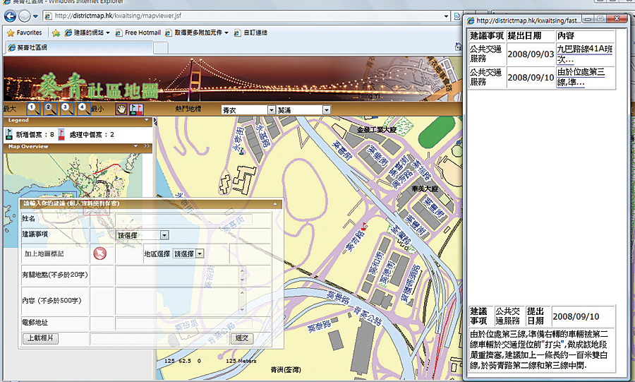
In an effort to better serve the growing community with her experience in GIS technology, Tang developed a virtual district council office on the Internet, coined Kwai Tsing District Map (www.districtmap.hk/kwaitsing). Powered by ArcGIS Server 9.2 for the Java Platform and SQL Server, Kwai Tsing District Map not only allows the public to access geographic information of the district but also provides an open platform for posting comments, suggestions, or complaints. ArcGIS Server 9.2 enables the Web site to dynamically generate maps with different layers and symbology at different scales, allowing Internet users to easily indicate the exact location tied to an issue or concern. The reported issues' spatial information is stored in SQL Server, using ArcSDE technology, for further analysis. ArcGIS allows different layers of information, such as buildings, transportation means, and recreational facilities, to be presented on the map. An Internet user may flag the exact locations and areas of the corresponding issues being reported, which are then verified and validated by the Web site administrator to determine follow-up actions. Issues addressed range from public facilities to community safety, transportation services, environmental issues, and recreational facilities. If the concerns prove to be valid, they will be forwarded to the relevant government departments. Blue flags on the map indicate locations of newly reported issues, whereas red flags indicate investigations in progress. This new way of information sharing has greatly sped up follow-up work by the office of the district councillor with timely and accurate information. Progress of investigation is also posted for public reference on a regular basis. Through the interactive map, the public can check on the status and updates of reported incidents around their community. "I am certainly pleased with this current setup and with favorable feedback from the community," says Tang. "I've been asked to share this experience with other district councillors on this new alternative communication channel." Compared to the traditional district council offices, which operate during specified office hours, the Web-based, GIS-enabled Kwai Tsing District Map escalates e-engagement, or public participation in community affairs, and collaboration within the district. Kwai Tsing District Map provides an effective and efficient system by which local residents can voice their needs, opinions, and concerns whenever Internet access is available. The current trend of Web 2.0 has greatly reshaped our expectations as most of us enjoy the social value to individuals and the business value for the private sector. Gov 2.0 is beginning to set a new trend for public figures and politicians to stay connected with the citizens and their supporters. With security, scalability, and interoperability being addressed, crowdsourcing—capitalized to engage the public in community affairs—can bring about broader value and benefits to both governments and their citizens. More InformationFor more information, contact Virginia Wan, corporate development manager, Global Business Department, Esri China (Hong Kong) Limited (tel.: 852-2730-6883, e-mail: vwan@esrichina-hk.com). |