Summer 2010
Summer 2010 |
|||||||
|
|
|||||||
GIS in a Changing World |
|||||||
|
By Jack Dangermond
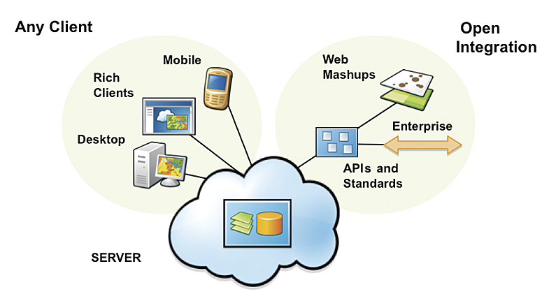
GIS has a long history of successfully adapting to new technologies, applications, customer types, and business models. From mainframes to minicomputers, UNIX workstations to PCs, desktops to the enterprise, each round of technical innovation has led to improvements for GIS. Today, GIS continues to evolve in response to infrastructure changes. The distributed computing environment enabled by the Web introduces a whole new set of challenges and opportunities. Merging with and adapting to the latest advances are making GIS easier to use, more collaborative, more powerful, and ultimately more useful for the work you do every day. The CloudCloud computing delivers technological capabilities on demand as a service via the Internet. Rather than the classic computing model of operating system plus software applications with files and database storage, "the cloud" model consists of services, clients, hosted content, and virtual machines. In other words, you do not load and run software and store data on your computer; you log in and use the system in the cloud. In addition to cloud computing on the public Internet, the same pattern can be implemented within a smaller, more secure community (private cloud) using the same concepts.
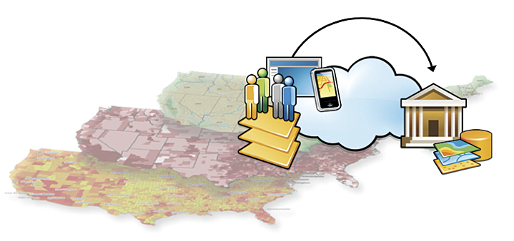
Cloud computing is emerging as an important technology trend in almost every industry, including the GIS community, and rapidly moving into the mainstream. We announced recently that ArcGIS 10 is cloud ready, which means that people will be able to rent and deploy GIS servers in the cloud, quickly and easily scaling their system up to solve large problems. For many users, this will provide a more efficient solution for maintaining infrastructure. Also, for many government agencies, it provides a solution for them to serve their data without the cost of administering hardware. CrowdsourcingSometimes referred to as volunteered geographic information or user-generated content, crowdsourced data is contributed by nonauthoritative sources (e.g., everyday citizens). The challenge for GIS practitioners is to ensure the usability of this data in a GIS workflow or to turn this crowdsourced data into useful geographic knowledge. This can mean checking the data to make sure that it is authoritative; it can also mean getting involved in data collection, structuring the process to ensure that the collected data has meaning and is appropriate as well as authoritative. Long the keepers of purely authoritative data, GIS practitioners are beginning to take crowdsourced data seriously. Crowdsourcing gives ordinary citizens the opportunity to provide feedback directly to the government. It can significantly augment authoritative datasets. It provides extraordinary opportunities for citizen science. And it can put a virtual "army" of volunteers on a large project in short order. GIS tools supporting crowdsourcing will change the way organizations collect and manage spatial data. New features in ArcGIS 10 give users the ability to modify geographic content within any Web mapping application and provide a venue for online communities to become active contributors to geodatabases. Web editing makes it easy to capture ideas and observations for distributed problem solving and extend GIS editing capabilities to more people within the organization. These capabilities allow everyone—from authoritative data editors to citizens on the street—to contribute content to the geodatabase. This will enrich GIS, giving GIS practitioners new types of data to use, manage, interpret, and incorporate into their work. NeogeographyThe neogeography movement—emphasizing ease of use, visualization, mashups, etc.—has been successful at changing the way society uses and interacts with geographic knowledge. Purveyors such as Google and Microsoft have made great advances in basic mapping, visualization, and mashups and, in the process, have shown us new user interface patterns. Esri is learning from these new patterns, incorporating such ideas into our next generation of software. As a result, the distinction between the world of neogeography and the GIS world is gradually disappearing.
One of our primary goals is to make our technology much more straightforward. We believe ArcGIS 10 is an order of magnitude easier to use than previous versions. This simplification comes from a new focus on how people will use the information and capabilities of GIS, resulting in a simple yet powerful system for working with maps and geographic knowledge. These changes will greatly increase usability by GIS practitioners as well as society in general. CollaborationNew collaborative technologies are redefining how we work together and share information at every scale. This collaboration crosses traditional lines, such as organizational boundaries, professional domains, and geographic borders. Sharing gives people access to vast stores of knowledge that were previously difficult or impossible to obtain and leads to more informed decision making. ArcGIS is now online. This means that users can share and discover maps and apps and create mashups through virtually any client—ArcGIS Desktop, smartphones such as iPhone, and browsers. Developers can also leverage ArcGIS Online to build and deploy applications. Having ArcGIS Online gives users the power to quickly find, share, and use geographic content from Esri as well as the user community. Through ArcGIS Online, GIS professionals will create knowledge, maps, and models and easily publish them for anyone to use. They will share their work through groups that they can create to collaborate on specific projects and by building communities with common interests. No one organization can create the GeoWeb or own the entire global spatial data infrastructure. This will be done by thousands of individuals and organizations all over the world creating geoservices and building applications on top of this infrastructure, using new collaborative tools. GIS Is Changing
GIS has proved to be a flexible, adaptive technology, evolving as the ecosystem around it changes. At each step in this evolution, GIS has not just adapted to these changes but embraced them, becoming more powerful and more valuable. Recent technological advances are helping us reenvision what a GIS is in a new context. As a Web-hosted or cloud-based system with ready-to-use maps and apps, GIS is rapidly moving toward the vision where it can be used anywhere, anytime, by anyone. How we use GIS, the way we interact with it, and the way it interacts with the world are all changing. While some of this change has been and will be driven by new tools and technology from Esri and others, the biggest driver of change is you, the GIS user. We're not redefining GIS; you are. You're telling us what technologies we need to embrace; what new functionality we need to add; and perhaps most significant, you are showing us through application of these new technologies how GIS can be used in ways we never dreamed possible. |
 The cloud. Crowdsourcing. Neogeography. Collaboration. The geospatial industry, the IT environment, and the world around us are all changing rapidly. We often talk about how GIS is changing the world. But today I want to spend some time talking about how the world is changing GIS.