Summer 2010
Summer 2010 |
|||||||
|
|
|||||||
Ensuring Future Access to Digital Geospatial Data
Library of Congress Takes Leadership |
|||||||
Highlights
GIS gives us the dramatic ability to create maps that resonate in our imaginations and enable us to tell compelling stories of change over time. The increase in use of GIS has brought digital geospatial data into the lives of millions of people while exponentially increasing the quantity of data under management.
While digital geospatial data is increasingly accessible, it is also fragile and at risk of loss unless efforts are made to preserve it and keep it accessible over the long term. How will we ensure that the digital records of our contemporary landscape will remain accessible in the future? The United States Library of Congress is addressing this issue. The mission of the Library of Congress is to make its resources available and useful to the United States Congress and the American people and to sustain and preserve a universal collection of knowledge and creativity for future generations. In 2000, the library established the National Digital Information Infrastructure and Preservation Program (NDIIPP) with the mission to develop a national strategy to collect, preserve, and make available significant digital content, including geospatial data, for current and future generations.
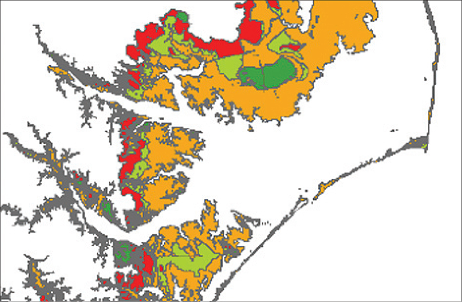
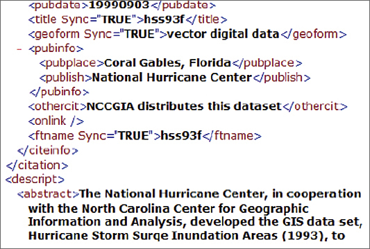
NDIIPP has established collaborative projects that build on and leverage existing activities and workflows for digital preservation purposes while modeling useful recommendations and approaches. These partnerships between academia; government; and GIS industry players, such as Esri, have served to share research discoveries and help guide the development of GIS for preservation awareness. In 2004, NDIIPP funded the North Carolina Geospatial Data Archiving Project (NCGDAP), a collaboration between the North Carolina State University Libraries and the North Carolina Center for Geographic Information and Analysis, to gain a richer understanding of the technical challenges associated with preserving geospatial data. To help cultivate an understanding of temporal data management as a customer problem, NCGDAP met with selected Esri development teams, including the geodatabase team, in April 2005 to discuss preservation challenges and concerns. NCGDAP later evolved into the Geospatial Multistate Archive and Preservation Project (GeoMAPP), adding the states of Kentucky and Utah and continuing to explore geospatial data preservation issues across state lines. GeoMAPP has continued the contact with Esri and other industry representatives through the National Geospatial Advisory Committee (NGAC), an organization established under the auspices of the United States Federal Geographic Data Committee (FGDC) to provide advice and recommendations related to the management of federal and national geospatial programs and the development of the National Spatial Data Infrastructure. GeoMAPP has continued to engage the geospatial industry on the preservation issue through presentations at the 2010 Esri Federal and International User Conferences. The engagement with Esri has helped GeoMAPP direct industry attention toward identifying user needs related to preservation activities and initiating a discussion that encourages Esri and other private-sector entities to identify opportunities to enable geospatial content preservation, retention, discovery, and long-term access in their tools and services. This engagement with industry has helped inform the broader NDIIPP approach to preserving digital geospatial information and has informed a proposal to develop a centralized online environment to share comprehensive information on the challenges and benefits of preserving digital geospatial data. The Geospatial Data Preservation Web portal will promote awareness of the fragility of digital geospatial materials to creators, legislators, funders, users, and the general public while also providing an authoritative resource on preservation strategies and tools for creators, users, and professionals charged with the management of critical geospatial information. Bill Lefurgy, the Library of Congress manager responsible for the geospatial preservation portal, notes, "Digital geospatial resources have significant value to Congress and to people everywhere. But keeping the data available over time is a challenge. Data stewards have told us that they need a Web-based clearinghouse that will provide the most current information about geospatial preservation tools, services, and practices." NDIIPP will develop the portal in partnership with the Center for International Earth Science Information Network (CIESIN) at Columbia University in New York. According to Robert R. Downs, the senior digital archivist and senior staff associate officer of research at CIESIN, geospatial data faces the same pressing set of preservation problems affecting many other kinds of digital data and information (degrading media, rapid software and hardware obsolescence, incomplete standards), but geospatial data has unique preservation issues that will be addressed by the portal.
The direct impetus for the information portal came out of observations garnered during NDIIPP's Framing a National Preservation and Access Strategy for Geospatial Data summit held in November 2009. This stakeholders' convening session was designed to understand the broad sweep of stewardship organizations involved with geospatial information creation, preservation, and access; get input about the types of digital geospatial information that are priorities for preservation; learn about current stewardship roles and responsibilities; and identify gaps in the geospatial information life cycle in terms of preservation and access. The summit identified stewardship organizations—such as FGDC, the National Archives, the National Climatic Data Center, the National States Geographic Information Council (NSGIC), and the U.S. Census Bureau—as the initial audience for the discussion, but there are plans to engage the wider geospatial community in the near future. The clear need emerged from the summit for an outreach program to broadly inform the public, geospatial users, and funders about the value of geospatial data and why it should be preserved. This led to the planning for the portal, which will be developed and rolled out over the course of 2010. Portal topics will include geospatial data policy, provenance, intellectual property rights, confidentiality, appraisal and selection, geospatial data deposit, data preparation, documentation, preservation metadata, software dependence, persistent identifiers, and storage media. The initial planning phase will include the solicitation of inputs from key stakeholders and potential users, development of an informal advisory committee drawn from experts in various disciplines related to geospatial data and its preservation and selected user community representatives, and conduction of an initial requirements analysis. This planning phase will determine the final contents of the portal, which will likely include introductory documents promoting an understanding of geospatial data preservation; links to current geospatial preservation projects and resources from government agencies, organizations, and associations; information on relevant standards, tools, policies, and examples of successful (and unsuccessful) geospatial data preservation projects and approaches; educational and training opportunities and resources; and a calendar of relevant meetings, conferences, workshops, and seminars on geospatial preservation. More InformationFor more information on the Library of Congress digital preservation initiatives, visit www.digitalpreservation.gov or contact Butch Lazorchak, digital archivist, U.S. Library of Congress (e-mail: wlaz@loc.gov). Information on the GeoMAPP project can be found at www.geomapp.net. Information on the Center for International Earth Science Information Network at Columbia University in New York can be found at www.ciesin.org. For more information on the Framing a National Preservation and Access Strategy for Geospatial Data summit, visit www.digitalpreservation.gov/news/events/other_meetings/ geosummit09/index.html. |