Summer 2010
Summer 2010 |
|||||||
|
|
|||||||
Emerging Technology—GIS on a Table—Improves Government Response
Mexico City's Earthquake Drill Shares Responsibility with Citizens |
|||||||
|
By Chris Phillips and Anthony Starr Highlights
On September 19, 1985, Mexico City, Mexico, experienced one of the most devastating earthquakes in history. The magnitude 8.1 quake shook the city in two separate tremors, burying more than 10,000 people amid the city's rubble. Mexico City officials and citizens commemorate that event by conducting an annual citywide evacuation and simulation, in large part designed to better prepare the city for similar catastrophes in the future. The responsibility for protecting citizens and conducting the annual simulation exercise falls on Mexico City's Civil Protection Department.
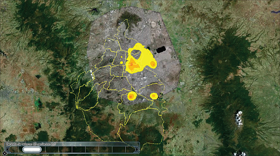
According to the head of Mexico City's government, mayor Marcelo Ebrard, this annual exercise allows the city to "measure our response capacity," which is critical in understanding the current state of the city's preparedness. The ScenarioIn 2009, the evacuation drill simulated a 6.9 magnitude earthquake with its epicenter in Atoyac de Alvarez, Guerrero, and included the assumption of a total collapse of the National Lottery building located on Paseo de la Reforma. The 2009 exercise proved to be an extraordinary demonstration of government and citizen collaboration. According to Mexico City's federal district government, the level of civilian participation reached a staggering 5.4 million citizens. More than 12,000 law enforcement personnel were involved in the evacuation, coordinating activities from more than 2,100 buildings within the city, a logistical challenge and dangerous proposition without the appropriate tools and resources in place. Compare that to 2001, when just 47,000 citizens participated in the drill, evacuating a total of 227 buildings. As citizen participation continues to rise, improved utilization of tools to enhance a shared understanding between city officials and citizens on evacuation routes, response plans, and contingency plans becomes imperative. A comprehensive GIS-based dataset, called the Hazards and Risk Atlas, helps the Civil Protection team assess high-risk locations throughout the city by standardizing a platform to manage the convergence of these datasets. The overall objective of the team is to improve its responsiveness based on the information contained in Mexico City's Hazards and Risk Atlas. Recently, ArcGIS Desktop, with the ArcGIS 3D Analyst extension and TouchTable technology, was added to the technology portfolio, helping Civil Protection officials broadly share the Hazards and Risk Atlas data, significantly improving the city's responsiveness.
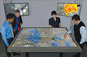
Innovative SolutionsImplementing a standard format for archiving GIS data and finding a better way of disseminating that data between city officials and citizens are critical to improving the city's response capacity. During the 2009 evacuation simulation, data in Mexico City's Hazards and Risk Atlas was published using ArcGIS Desktop and the ArcGIS 3D Analyst extension. The next step was to access the project through the TouchTable interface to improve the way data is manipulated and shared. The Civil Protection team used multitouch gestures and visualization tools to communicate objectives and give real-time updates on the state of affairs to authorities. The combination of tools used in this exercise enabled a broad set of participants in locations throughout the city to share a common picture and reach a joint understanding of the situation. To accomplish this, documents used in this exercise were authored using the ArcGIS 3D Analyst extension's ArcGlobe application to include 61-centimeter satellite imagery for all the federal districts and a combination of shapefiles offering a geographically accurate and meaningful representation of available assets. The team marked and tagged geospatially referenced assets with relevant photos or metadata to supplement the group's understanding of asset allocation, emergency vehicle location, and building details. Multiple instances of the TouchShare and ArcGIS software running on desktops, laptops, and other devices used by the Civil Protection team allowed details to be shared enterprise-wide regardless of the users' geographic locations. In addition, network visualization and sharing over multiple TouchTables and conventional computing devices facilitated separate groups of users being able to see, interact with, and share the exact same data from disparate locations throughout the city. The OutcomeData gathered from this annual simulation allows incremental improvements in response time through the study of historical data. This information is added as layers in the ArcGlobe project file and allows response teams to prepare for future events based on geographically relevant data from past events. As new data is acquired during the annual exercise, the data is added to the city's data archives, improving understanding and preparedness for future events.
Using Mexico City's historical data, officials are able to more accurately predict likely danger zones that may affect future real estate and development considerations and lead to improved seismic building codes and improved geographic locations for new structures. In addition, in the event of a crisis, the city's Civil Protection team is able to better target populated venues and buildings based on location or temporal data, such as time of day or year. This improved understanding allows the creation of a well-devised emergency response plan and greater efficiency during critical events. Ebrard summarized the benefits to the evacuation drill as "great for training people, and the drill permits us to evaluate and improve the government's reaction, as well as [improve the reaction time] of all emergency units." The annual evacuation event not only is designed to establish better preparedness for the Civil Protection Department but also establishes shared responsibilities between governmental authorities and the citizens of Mexico City. About the AuthorsChris Phillips is the product manager for TouchTable, Inc. Phillips' experience includes more than 12 years of managing new technologies in the biotech, nanotechnology, surface computing, and GIS markets. His work has been documented in a variety of print publications, ranging from scientific journals to textbooks. Anthony Starr is the senior technical writer at TouchTable, Inc. Starr has written technical documentation and created illustrations and marketing graphics for the power, pharmaceutical, military, networking, surface computing, and GIS industries. More InformationFor more information, contact Mark Abady, CEO, Counter Intelligence Mexico (e-mail: abady@counterintelligence.com.mx), or Rocky Roccanova, CEO, TouchTable, Inc. (e-mail: rocky@touchtable.com, tel.: 626-639-5473). |