Summer 2010
Summer 2010 |
|||||||
|
|
|||||||
Namibia Launches GIS-Based Land Evaluation Project |
|||
Highlights
The Republic of Namibia, located in southern Africa on the Atlantic Ocean, gained its independence from South Africa in 1990 and has since benefited from a stable multiparty democracy. The country is home to the Directorate of Valuation and Estate Management (DVEM), which, under the supervision of the Namibian Ministry of Lands and Resettlement (MLR), was faced with a critical problem in the consistency of the determination of its land values due to the use of a semiautomated approach applied to the assessment process.
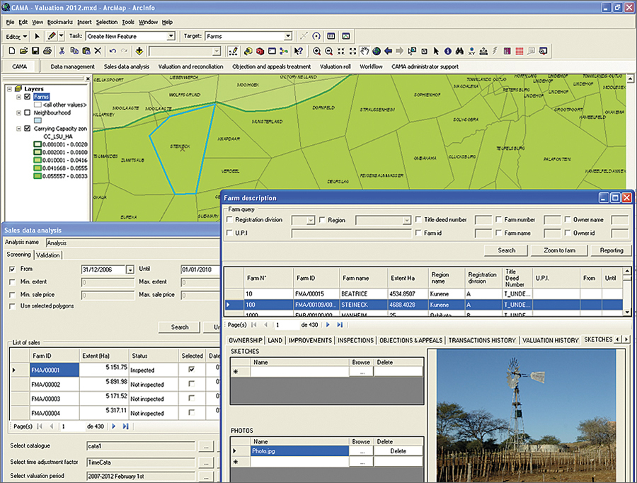
This approach resulted in a slow, cumbersome, tedious, and resource-consumptive process, prone to mistakes and irregularities and therefore undermining the ability to defend the results obtained in a valuation court. The principal desire of DVEM was thus to convert to an automatic mode of value assessment and achieve accuracy and consistency in the determination of agricultural land values for land tax purposes. At the heart of the discussion was the need for an application that would provide the ability to value agricultural land for land tax purposes and generate valuation rolls in accordance with the local legal framework. The solution had to be adaptable to the particular local context. The search for an appropriate software application was not the only preoccupation of DVEM; it also needed equipment updates that would support the new solution, as well as training on how to actually make it work. The local teams needed to be reinforced. MLR required a hands-on approach from an experienced consultancy firm—one that could not only provide it with the adequate solution but also give MLR all the tools it needed to make the solution work and be independent in the management of the agricultural land taxation process and national land heritage. An international tender was launched to find the business partner that had access to the right solution, allowing the calculation and visualization of land values through a GIS. The application had to be, above all, transparent, homogeneous, rational, and simple. The system needed to permit data exchanges between the land valuation system, the computerized deeds registration system, and the cadastral system. After careful deliberation, MLR chose IGN France International, because it believed the company had the answer to its problem in the IGN-developed computer-assisted mass appraisal (CAMA) solution, which corresponded to MLR's needs. ArcGIS Desktop software-based CAMA is designed to bring transparency to land taxation calculations and is easily customizable to local contexts. ArcGIS was chosen because it stood out as the software that IGN was completely confident would fit its client's specific needs and was perfectly suited to the project's goals. Esri also helped IGN respond to the client's needs by providing ArcObjects libraries that facilitated the development of an application in Visual Basic .NET. This application was used during the automation process and focused on the transparency of land valuation calculations. The IGN-developed solution is divided into seven distinct GIS modules (Data management, Sales data analysis, Valuation and reconciliation, Objection and appeals treatment, Valuation roll, Workflow, and CAMA administrator support). These modules are concentrated on one toolbar, while a second toolbar is used to manage the connection to the application and to the Oracle database that contains the land values. To ensure success, the Namibian project was begun near the end of 2008 with full and complete training on the GIS software provided by the local company, Geocarta. Once this general training was completed, IGN held three days of further on-site GIS training specifically designed to boost the local teams' capacities in the field of land management. Once the training was finished and the CAMA system installed, technical assistance was also provided to help smooth any bumps in the road that MLR might encounter. Other training sessions that were held focused primarily on land assessment in theory and, more specifically, on problem-solving tools developed specially for ArcGIS. The Namibian project was ultimately a success because of the level of cooperation present throughout its duration. More InformationFor more information, contact Kelsy Meyer, marketing and communication assistant, IGN France International (e-mail: kmeyer@ignfi.fr, tel.: 01-42-34-56-49, Web: www.ignfi.fr). |