Summer 2010
Summer 2010 |
|||||||
|
|
|||||||
GIS Professionals Helping Others
URISA's GISCorps Is a Place for Service |
|||||||
|
"The best way to find yourself is to lose yourself in the service of others."—Ghandi
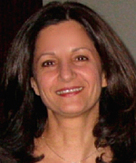
URISA's GISCorps coordinates the deployment of GIS volunteers to communities in need around the world. These volunteers provide their GIS expertise remotely or on-site and have been involved in a variety of missions. The business of GISCorps is run by a core committee of six individuals who volunteer their time in the evenings and on weekends to keep the program running. Elhami is the GIS director for Delaware County in Ohio and has been working for that county for 21 years. In her spare time, she can be found administering various aspects of GISCorps, such as finding recruits for a project in Southeast Asia. Why? "Helping others makes me happy," says Elhami. "If a person can help others, and do it in a timely manner in a way that meets other people's needs, it is the best success that can happen in a life." In October 2001, while attending URISA's annual conference in Long Beach, California, Elhami shared an idea with several of her colleagues. The idea was born out of a simple question that she put to those colleagues: "Would GIS professionals be willing to volunteer their time and expertise—for a short time—to communities in need?" The reaction to the question was very encouraging. In October 2003, after two years of brainstorming and presenting the idea to various groups, the URISA Board of Directors adopted GISCorps as an initiative and later as a program of URISA. As of April 2010, GISCorps has launched 60 missions in 30 countries around the world. Its volunteers have contributed more than 7,400 hours to those missions. "GISCorps assists nonprofit organizations, which, without our help, would not be able to serve their target groups," explains Elhami. "The initial concept was to build the organizations' GIS capacity so they, in turn, could better serve their communities. We teach their people how to use the technology, and we provide support until they become self-sufficient."
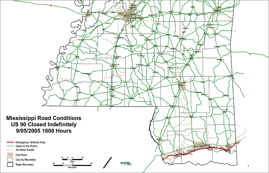
For example, a 2010 project is to build digital maps for North Korea. The United Nations World Food Programme (WFP), via the Information Management and Mining Program (iMMAP), needs maps so it can deliver services, food, and other necessities. It also needs to know the obstacles to getting to those locations. WFP sent a request to GISCorps for expert volunteers to conduct heads-up digitizing. Mapmakers, during the Union of Soviet Socialist Republics era, had created 400 hard-copy maps. Elhami and her coworkers looked at the specifications from WFP's request and estimated how many volunteers and volunteer hours would be needed to finish the project in six months. They found that it would take 20 volunteers contributing 180 hours each to complete the project. Since WFP wants to use ArcGIS for the project, volunteers are required to be adept in ArcGIS 9.3. Elhami scanned the database of volunteers and sent an announcement to people whose skill sets met the criteria of the request. Within the first hour after sending the announcement, 14 people had responded. These volunteers will never set foot in North Korea to work on this mission because everything on the project will be done remotely from the volunteers' locations, probably from home. Each volunteer just needs to donate time and expertise. GISCorps provided response support for the 2004 tsunami that hit the coasts of the Indian Ocean; 2005's Hurricane Katrina that devastated Louisiana and Mississippi; and, most recently, the earthquake that crumbled so many Haitian cities and villages. Some GIS volunteers do work on-site. In these cases, the requesting organizations are responsible to pay the volunteers' travel and accommodation expenses. However, in a disaster situation, volunteers may need to find a free spot for a sleeping bag in the corner of a crowded community building.
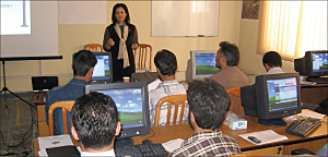
"People in the GIS community are very special," notes Elhami. "It has been an honor to be a facilitator at GISCorps that has become a conduit of help to so many. We have sent people all over the world to provide assistance that makes other people's lives better." Raised in Tehran, Iran, Elhami and her husband became architects. They moved to the United States 25 years ago, and Elhami went to graduate school at Ohio State University. While working there as a research assistant, she discovered GIS technology. She fell in love with GIS and its concepts. She was then hired by Delaware County for her GIS expertise. She also taught GIS at the university for 10 years but finally stopped teaching because of her commitment to GISCorps. The first on-site mission that Elhami worked on was in Kabul, Afghanistan. She wanted to learn what it was like to work at a location and know firsthand how hard it would be. The project was in partnership with the United Nations Development Programme (UNDP) and Afghanistan Information Management Services (AIMS). AIMS had set up shop in Pakistan because the Taliban forces were ruling Afghanistan. Once the Taliban forces were removed from power, AIMS relocated to Afghanistan and requested support. Specifically, AIMS wanted to grow its GIS capacity by moving from ArcView to ArcGIS. At that time, Elhami was an authorized ArcGIS instructor, so she taught Afghans how to use ArcGIS. GISCorps has since sent three more volunteers to provide advanced ArcGIS and ArcGIS Server training. "Kabul was interesting," says Elhami. "I learned a lot. I thought that if a country as turbulent as Afghanistan can welcome a volunteer, any country can. I have since kept in touch with those people, and two of my AIMS Afghan students actually came to last year's Esri User Conference." Of GISCorps' 60 missions, 38 have been handled remotely. When Elhami initially conceived the program, she had not imagined that people could provide support from home. The Internet technology at that time was unable to support the work that needed to be done. But now, this is possible, and, what's more, affordable. People—such as mothers with young families—who would not have previously been able to work can now volunteer their help.
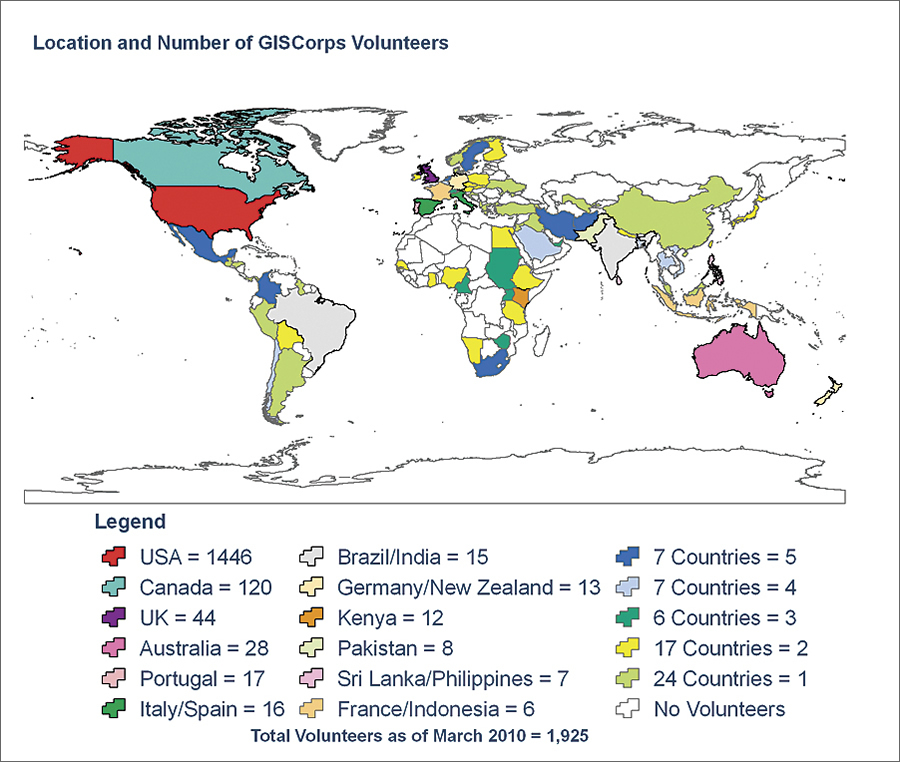
As of March 2010, GISCorps has attracted 1,925 volunteers. These volunteers come from 76 countries around the world. People interested in volunteering can register via the GISCorps Web site. Organizations can also use the Web site to request GISCorps' assistance. These requests are reviewed and screened by GISCorps' core committee. "We have no paperwork and no bureaucracy, and work gets done quickly," says Elhami. "E-mails fly, and we give fast answers and get quick responses. This method has proved very successful. Everybody cares, everybody knows why we are here, and we try to do our best to make things happen." More InformationTo see how you can become involved, visit the GISCorps Web site at www.giscorps.org. |
 Some people are skillful, some people are givers, and some people are both. People who are trained GIS professionals have many opportunities to serve the earth and help its environments and its inhabitants. Shoreh Elhami has made a way for GIS professionals to offer their skills to people in need, whether it be to support humanitarian relief, enhance environmental analysis, or provide support for disaster response. Cofounder of the volunteer GIS assistance program GISCorps (