Summer 2010
Summer 2010 |
|||||||
|
|
|||||||
Using GIS to Bring Accountability and Transparency to International Relief Efforts |
|||
Highlights
More than 100 international agencies, including nongovernmental agencies, came to the aid of Aceh Province in Indonesia after the 2004 tsunami. That year, a magnitude 9.1 earthquake in the Indian Ocean set off a devastating tsunami with waves up to 30 meters high striking Southeast Asia. Almost 230,000 people in 14 countries lost their lives. The greatest damage occurred in Aceh Province on the northern tip of Sumatra. The coastal region was leveled. Water rushed inland as far as four kilometers, in one instance carrying with it a 2,600-ton barge and depositing it to languish as a reminder of what had happened. The tsunami severely impacted services and infrastructure throughout Aceh Province. Water, sewer, and electrical systems were destroyed and had to be reestablished. Even transporting supplies and the labor force to the affected areas was hampered, because the road along the west coast had been severely damaged or completely washed away in large sections.
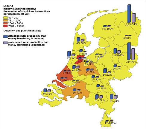
Seeing the region today, little evidence remains of the devastation, as Aceh Province continues to not only recover but also, as the government's motto says, "build back better." Understanding Geography to Provide More Effective AidFrom the beginning, GIS played an important role in mapping the impact of the disaster, guiding emergency responders to the devastated areas, and coordinating the relief effort. International agencies' host nations contributed US$4.5 billion to the rebuilding effort. It was important to ensure that contributions went to the people who needed the help so that the next time a disaster occurred, such as the magnitude 7 earthquake in Haiti and the magnitude 8.8 earthquake in Chile, countries would once again be willing to provide relief. Trying to meet the challenge of following the global audit trail with the help of GIS is the International Organization of Supreme Audit Institutions (INTOSAI). INTOSAI, based in Vienna, Austria, serves as an umbrella organization for the international government audit community. The organization is autonomous and nonpolitical, working with the United Nations Economic and Social Council (ECOSOC). ECOSOC sets forth policy recommendations for promoting higher standards of living; identifying solutions to international economic, social, and health problems; and encouraging universal respect for human rights. For more than 50 years, INTOSAI has provided a framework to improve government auditing worldwide. Over the last few years, INTOSAI has learned how to improve the transparency, accountability, and audit of the flow of international aid by using GIS. Wanting to take a lesson from one of the countries affected by the tsunami, representatives of INTOSAI's Tsunami Task Force attended a weeklong training course in the spring of 2006 at Aceh's Syiah Kuala University. It was hosted by the GIS and Remote Sensing Laboratory at the university. The Tsunami Task Force members learned how to use geospatial information to help plan, coordinate, monitor, and audit disaster-related aid. The session was taught by staff from Badan Rehabilitasi dan Rekonstruksi NAD-Nias, the temporary building and reconstruction arm of the Indonesian government in Aceh Province. Auditors from the Indonesian Supreme Audit Institute (Badan Pemeriksa Keuangan) followed an intensive course focused on GIS and the use and integration of imagery data in their work. Training was provided by the International Institute for Geo-Information Science and Earth Observation, now part of the University of Twente in the Netherlands. Esri provided ArcGIS licenses for a hands-on tutorial. Pilot Leads to Auditing WorldwideAs a result of the training, the Netherlands Court of Audit—the chair of the Tsunami Task Force and a member of INTOSAI—set up a knowledge center in 2007 that explores how GIS and geospatial data can be used in auditing. The center was supported by Esri Nederland B.V., Esri's distributor in the Netherlands. A year later, the Netherlands Court of Audit obtained ArcGIS licenses and trained its first group of auditors. Today, it uses GIS to map the results of combating money laundering in the Netherlands. The technology is also used to help social programs target services for homeless children and for the distribution of Dutch funds for development assistance worldwide. By providing a visual representation, the Court of Audit can account for where money has gone and measure the success of policy measures. INTOSAI is now urging nations and agencies to use GIS and geospatial information for transparency and accountability as aid flows to Haiti and Chile for the earthquake recovery effort. In the Netherlands alone, about 100 million euros were collected for Haiti, with about 43 million euros coming from the Netherlands government. The Netherlands Court of Audit intends to use its GIS knowledge and expertise to advise the Dutch Ministry of Foreign Affairs and a group of major nongovernmental organizations on how to enhance transparency and accountability for tracking aid monies for Haiti. GIS Is Required for Effective International Aid AuditingINTOSAI promotes the use of GIS and imagery data to plan, coordinate, and monitor disaster-related aid in order to prevent waste, duplication, fraud, and competition between aid organizations. The organization believes using GIS leads to facilitating more efficient and effective audits of disaster-related aid since it is geographic in context: aid is intended for a specific location, whether it be to reconstruct and rehabilitate infrastructure, buildings, and farmlands or assist the people who live there. Besides the Netherlands Court of Audit, examples of effective use in aid abound, including the United Nations World Food Programme, which uses satellite images and GIS to locate refugees and plan the distribution of food. The International Criminal Court uses satellite images to locate refugee camps and gather evidence on human rights violations, such as the destruction of villages. The European Commission's Directorate-General for Agriculture has used GIS successfully over several decades in its Monitoring Agriculture through Remote Sensing project. The program helps European member states make decisions on where aid should be provided based on remotely sensed data and statistical input to allocate agricultural and environmental subsidies. GIS benefits all stages of an audit from assessing relevant risks and designing, conducting, and analyzing the audit to communicating the results:
INTOSAI has published its findings in a report, Lessons on Accountability, Transparency, and Audit of Tsunami-Related Aid. INTOSAI also produced and distributed a flyer to help the auditing community understand why GIS and geospatial information are so important to the relief effort. More InformationFor more information, contact Egbert Jongsma, Netherlands Court of Audit (e-mail: e.jongsma@rekenkamer.nl), or visit www.intosai.org to read more about INTOSAI's final report on the accountability for and audit of disaster-related aid. |