Cindi Salas' Passion for GIS Is Undeniable
 As director of land and field services for Houston, Texas-based CenterPoint Energy, Cindi Salas has a knack for simplifying and improving processes. She is known in the utility industry for her ability to make workflows more efficient and is adventurous in her use of technology—pushing perceived limits of integration and expansion.
Given Salas' aptitude, it makes sense that, for her, "GIS is the right fit."
In 2009 at the Esri International User Conference, Esri president Jack Dangermond presented Salas with the Enterprise Application Award, recognizing tremendous response efforts in the wake of Hurricane Ike. CenterPoint was able to restore service to 75 percent of its customers within 10 days of the storm's devastating landfall in Galveston, Texas. A key tool for CenterPoint Energy: an outage management application built on ArcGIS technology. The utility also created a multitude of GIS maps to analyze the situation before, during, and after the storm. This information was shared with customers and media, government, and support agencies.

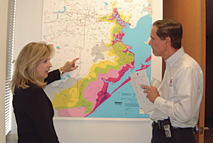
Cindi Salas
In her current role, Salas oversees CenterPoint's enterprise GIS department, surveying and right-of-way management, underground line locating, and joint-use facilities.
With more than 5 million metered customers, CenterPoint Energy is composed of an electric transmission and distribution utility serving the Houston metropolitan area, local natural gas distribution businesses in six states, a competitive natural gas sales and service business serving customers in the eastern half of the United States, interstate pipeline operations with two natural gas pipelines in the midcontinent region, and a field services business with natural gas gathering operations also in the midcontinent region.
Twenty-seven years ago, Salas joined CenterPoint, following nearly 13 years with Allegheny Energy (now First Energy), where she worked as a technician with responsibility for budgeting and estimating all aspects of electric operation and maintenance, from distribution to power plants, as well as transmission line route certification.
When she started at CenterPoint, Salas says, GIS was protected and not well understood throughout the company. GIS was restricted to a back-room mapping operation.
"GIS was this big monster that no one could get their arms around," Salas says. "I knew what GIS was, and I wanted to have access to it. At first I was not allowed. I think I was told I would have to fund a new server, that it would be too costly, and that they just couldn't open up access." But that didn't discourage Salas.
Streetlights Create a Lightbulb Moment
About 20 years ago, while Salas was responsible for CenterPoint's streetlight design, a weighty task was set before her. She and a few additional forward-thinking individuals were asked to devise a new process to move information from the field into the company's GIS within five days of completing the work in the field. Typically, it would take months from the time of fieldwork completion to an update in the GIS. The team responded to the challenge, outlining the process changes that could be implemented to effect the dramatic transformation.
In 2002, Salas was already promoting the power of GIS in analyzing predicted storm surge relative to the utility's assets and potential areas of damage.
"After that, I was seen as an advocate for GIS, trying to open access to other users and leverage the system for all that it could do," Salas says.
Envisioning further opportunities to exploit GIS technology, Salas outlined a new process to manage the huge volume of streetlight additions and improvements at CenterPoint. GIS was incorporated into a new workflow management system that quickly moved new street lighting requests (from homeowners associations or municipalities) through engineering, design, survey, construction, and billing. The workflow was so integrated with GIS that the city could request streetlight upgrades via an online system, the system would look for the specific lights in the GIS to determine which type of upgrade was needed, a sketch would be automatically generated for the crews to perform the work, and the corresponding updates would automatically be made in GIS.
Under this new process, CenterPoint's service area neighborhoods were brought up to a higher safety standard as the streets were upgraded with brighter lights.
"We truly embraced the tremendous potential of GIS technology, so we then started to think about using GIS to design more complex streetlight layouts," Salas says. "It was our plan to be the poster child for using GIS for design, whetting the appetites of others. It took a while, but we got there. And GIS did reach visibility elsewhere in the company as a result of these efforts—they saw GIS for what it could do."
Building the Enterprise Organization and System
Many years later, with the acquisition and merging of gas companies by and with what was previously an electric company, CenterPoint Energy was committed to developing an enterprise GIS organization and system. That decision was made in 1999, and Salas was selected to be one of the leaders in that endeavor.
"Once we decided on the common platform, we had to convert essentially 10 different systems to the latest Esri technology," Salas says. "We worked closely with our friends at Esri on developing the object-oriented data models, replacing functionality, and developing new applications that replicated what was being done with other tools."
CenterPoint completed its GIS conversion efforts under Salas' continued nurturing, and usage of the technology flourished throughout the organization.
Today, CenterPoint Energy's enterprise GIS supports more than 80 applications for engineering, design, construction, maintenance, a variety of fieldwork, regulatory reporting, managing assets, and more. Eight geodatabases house information about the company's electric and gas distribution and transmission assets. This data is available throughout the company to all 8,000 employees.
From Smart Design to Smart Grid
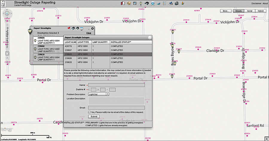
CenterPoint's current ArcGIS API for Flex application allows customers to select and report streetlights that are out. The application is interactive and provides customers with repair status updates.
Along with many utilities worldwide, CenterPoint is focusing on smart meter and smart grid projects. As the recipient of US Department of Energy funding, CenterPoint is committed to its deliverables, including completion of the first phase of a self-healing smart grid in 2013. The grid will use smart meters, power line sensors, remote switches, and other automated equipment to improve power reliability and restoration in the Greater Houston area.
"To that end, as we implement our advanced distribution management system [ADMS], GIS is front and center and an integral part of building the smart grid," Salas says.
Since GIS already houses the utility's critical asset and circuit information, it will feed that data to the ADMS, along with regular updates, as changes are made to the physical network.
GIS assists in the design of equipment—smart meters, cell relays, take-out points, intelligent grid switching devices—as it is installed in the field. Server-based GIS applications provide a multitude of diagnostic capabilities relative to smart meter integration and equipment performance.
The Future's So Bright
"I see increased usage of GIS via web services," Salas says. "I see it becoming easier to integrate GIS with other systems because of the Software-as-a-Service environment. Where we used to hard code interfaces, we are now writing services that can be consumed and reconsumed. I see that continuing to manifest as we leverage the cloud. I see GIS evolving for use in ways that we have yet to imagine."
Currently, Salas is focusing her efforts on the nontraditional aspects of GIS knowledge and data sharing between the public and private sectors—a move she believes impacts the greater good of the community. To that end, Salas participates in various industry-related associations.
Salas says her passion for GIS was ignited 20 years ago when she could envision the possibilities of the technology. That passion hasn't waned.
"In fact, the passion is stronger," she says. "The opportunities for GIS are limitless in a world where everything is somewhere."
For more information, contact Cindi Salas (e-mail: cindi.salas@centerpointenergy.com).