Exploring the Deeper Reefs and Volcanic Provinces of American Samoa
By Dawn J. Wright, Department of Geosciences, Oregon State University, and Jed T. Roberts, Oregon Department of Geology and Mineral Industries
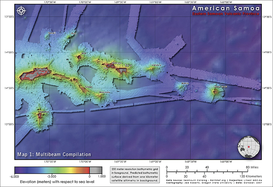
Bathymetry of American Samoa and the broader Eastern Samoa Volcanic Province. The multibeam bathymetry is 200-meter resolution, but for visual continuity, a 1-kilometer grid of bathymetry derived from the satellite altimetry of Sandwell and Smith (1997) is used as a backdrop (for this and the other figures). Map projection for this and all other figures is Mercator, and the map geodetic datum is WGS-84.
Remote sensing has made it possible to collect data on features and processes in the ocean over very broad scales, including bathymetry. Remote sensing is often thought of as space- borne or airborne, but for bathymetry, it is the waterborne sensing that is key. This is because sensors on satellites and aircraft are great at seeing the surface of the ocean but generally cannot look deeply into the water column, where the electromagnetic energy that they rely on is dissipated. Therefore, what can be perceived of the water column and the ocean floor must be done mostly with the aid of sound (acoustic remote sensing), as sound waves are transmitted both farther and faster through seawater than electromagnetic energy. To "see" the ocean floor, sound is essential not only for determining depth to the bottom but also for detecting its varying properties. In addition, the intensity of this reflection, or backscatter, can be used to resolve the shapes of objects or the character of the bottom (e.g., heavily sedimented and thus nonreflective, or glassy with fresh lava flows and thus extremely reflective). This makes it possible for us to understand the geomorphology of the ocean floor, especially with the aid of GIS to organize, integrate, and prepare intuitive maps from the acoustic remote-sensing data and, further, to develop methodologies with ArcGIS (through an Esri university site license) and tools for translating bathymetric data into useful products for characterizing and predicting benthic habitat and species assemblages.
American Samoa is home to many natural treasures, among them two of the most unique coral reefs in the world: the Fagatele Bay National Marine Sanctuary, which is the smallest, remotest, and only true tropical coral reef of the 13 sites within the US National Marine Sanctuary System, and the National Park of American Samoa, the only one south of the equator and with territory both on land and underwater. American Samoa (as opposed to the independent nation of Samoa directly to the west) is the only US territory south of the equator and is composed of five volcanic islands (from west to east: Tutuila, Anu'u, Ofu, Olosega, and Ta'u), as well as two small coral atolls, Rose and Swain.
Tectonically, the entire Samoan archipelago lies just east and 100 kilometers north of the subduction of the Pacific Plate beneath the northeastern corner of the Australian Plate at the Tonga Trench. In fact, this part of the world was most recently in the news after the magnitude 8.1 Tonga/Samoa earthquake of September 29, 2009, the deadliest in the region's history, with 9 deaths in Tonga, 149 in Samoa, and 39 in American Samoa, and with more than $150 million in damage. The Samoan chain is also unusual in that the islands are largest at the western end (Savai'i, Samoa) and deeply eroded in the middle (Tutuila, American Samoa); also, the easternmost feature (Rose Atoll, American Samoa) is a coral atoll that breaches the surface of the ocean instead of an active underwater volcano (seamount). In the Hawaiian archipelago, far to the north but oriented along a similar azimuth, these characteristics are completely reversed. However, the recent discovery of the underwater volcano Vailulu'u to the east of the Samoan chain by Hart et al. (2000) provides strong evidence for a hot spot (as opposed to a "plate tearing") origin for the islands and one that is consistent with the westward plate movement of the Pacific.
Researchers have recently focused on compiling the latest available bathymetry (the first regional-scale compilation of 14 cruises from 1984 through 2006) to understand the geomorphology of the entire Eastern Samoa Volcanic Province, which covers 28,446 square kilometers, with depths ranging from about 50 to 4,000 meters. For full details on methods, maps, and interpretations please refer to Wright et al. (in press) and Roberts (2007), and for other regions of the world see the forthcoming GeoHab Atlas of Seafloor Geomorphic Features and Benthic Habitats edited by Harris and Baker (in press). Analysis of this high-resolution data reveals scores of previously undocumented seamounts following the approach of Jordan et al. (1983) and Smith (1988). In addition to calculation of slope from the bathymetry, a shape analysis was conducted in which summit and basal diameter, slope of flank in cross section, basal depth, height, and azimuth were used to calculate basal and summit area, average height and slope, flatness (ratio of summit to basal area), elongation (ratio of basal minor to major axes), and volume (full methods, summary statistics) and resulting interpretations of shape-parameter relationships are detailed in Roberts (2007). In addition, an exponential distribution model of Smith and Jordan (1988) has been used to estimate the areal distribution seamounts across the American Samoa region, the first such analysis to be performed in a region of extensive mantle plume activity. The result of 2.8 � 0.2 seamounts per 1,000 square kilometers is within expectations for other regions of the Pacific Plate but toward the low end (e.g., Bemis and Smith, 1993; Scheirer et al., 1996). Until the exponential distribution model is applied to another area of hot spot volcanism, regional variation with respect to seamount density remains unclear.

Slope calculation of multibeam bathymetry of American Samoa and the broader Eastern Samoa Volcanic Province reveals scores of seamounts (51 previously undocumented). The slope grid is 200-meter resolution.
The Tulaga-Malumalu volcanic complex is connected on the ocean floor to the eastern edge of the main American Samoa island of Tutuila by a 40-kilometer rift. Malumalu has a young morphology, with few slope failures and a near-circular footprint. Tulaga exhibits a more erosive state. Its highly elongated form results from voluminous and continuous volcanic outpouring initiated at the southeastern flank of Tutuila. A brief lapse in shield volcanism creates a shallow saddle between Tulaga and Malumalu. Numerous small seamounts dot this coincident flank.
Tama'i, Soso, and Malulu are relatively small seamounts, with volumes of 58, 232, and 566 cubic kilometers, respectively (Koppers, 2010). These seamounts have not yet been sampled, and thus no studies of their geochemistry have been performed; little is known of their origins. All three are characterized by basal depths much deeper than those of en echelon seamounts (about 4,800 meters) and demonstrate undeveloped morphologies. Soso is unique in that it shows a clear structural relationship with the northeastern secondary rift extending from Tutuila. Tama'i and Malulu exhibit no such relationships with en echelon seamounts. While Tama'i is 30 kilometers north of Tutuila, there are smaller seamounts in the intervening space, suggesting that it is perhaps also a satellite of the Tutuila rift system. The mechanism for this association is not clear, however.
In the current global census of seamount habitats, which are some of the richest biological hot spots in the oceans (e.g., providing important habitats for coral, invertebrates, benthic fish, sea turtles, and sharks), only 200 have been sampled, and in no systematic fashion (Etnoyer et al., 2010; Pitcher et al., 2010), but detailed results from these studies hold promise for exploring a possible relationship between seamount shape and habitat. Indeed, studies of topographic/bathymetric position index indicate that it is important for species richness along a vertical biodiversity gradient (Guisan et al., 1999; Iampietro and Kvitek, 2002; Lundblad et al., 2006). Three Pisces V submersible dives were made to the submerged seamount flanks of Tutuila, where relatively mesophotic (lower light level) reefs with little human impacts occur (Wright et al., in press). The dives found that the base of extensive "live bottom" (coral cover =20 percent) was at about 36 meters in depth, and 91 species of fish and 32 species of invertebrates (including nine never before seen in the area) were identified; and small portions of previous benthic terrain maps were ground-truth (Wright et al., in press).
Knowledge of American Samoa mesophotic reefs is very limited, as they are the deepest and among the farthest in the archipelago from humans and thus help delineate what unimpacted coral reefs are like in the territory (e.g., Fenner et al. 2008). Unfortunately, there are no good examples of shallow, unimpacted reefs around Tutuila, where human impacts are greatest. Therefore, knowledge about natural, unimpacted reefs in the territory—including these deep, mesophotic reefs—is very important for gauging the impacts humans have had on reefs in the region.
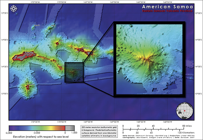
Detailed bathymetry of Malumalu Seamount.
About the Authors
Dawn J. Wright is professor of geography and oceanography at Oregon State University and director of the Davey Jones' Locker Seafloor Mapping/Marine GIS Laboratory. She has authored and edited several books, including Arc Marine: GIS for a Blue Planet (Esri Press 2007) and Undersea with GIS (Esri Press 2002). Wright serves on many editorial boards, including the International Journal of Geographical Information Science, Transactions in GIS, and the Journal of Coastal Conservation. She is a member of the National Academy of Sciences' Ocean Studies Board and a fellow of the American Association for the Advancement of Science. Jed T. Roberts is with the Oregon Department of Geology and Mineral Industries. Recent projects have included GIS support and cartography for the modeling and mapping of tsunami inundation for Oregon's coastline (funded through NOAA's National Tsunami Hazards Mitigation Program) and hazard modeling, GIS support, and cartography for mapping the exposure of buildings and infrastructure to Mount Hood's volcanic hazards (funded through the US Geological Survey's Cascades Volcanic Observatory).
For more information, contact Dawn Wright (e-mail: dawn@dusk.geo.orst.edu). For more information about seafloor mapping efforts in and around the American Samoa region, see the Oregon State University Davey Jones Locker Lab website dusk.geo.orst.edu/djl/samoa. GIS data, metadata, and other resources are available there, as well as in Data Basin's Aquatic Conservation Center online at www.databasin.org/aquatic-center. Parts of this article were extracted from the author's Esri Press publication Undersea with GIS (2002).
Announcement: Esri Appoints Dawn J. Wright as Chief Scientist.
References
Bemis, K. G., and Smith, D. K. Production of small volcanoes in the Superswell region of the South Pacific. Earth and Planetary Science Letters 118, 251-262, 1993.
Etnoyer, P., Wood, J., and Shirley, T.C., (2010). Box 12: How large is the seamount biome? Oceanography 23 (1), 206-209, 2010.
Fenner, D., Speicher, M., Gulick, S., Aeby, G., Aletto, S. C., Anderson, P., Carroll, B., DiDonato, E., DiDonato, G., Farmer, V., Gove, J., Houk, P., Lundblad, E., Nadon, M., Riolo, F., Sabater, M., Schroeder, R., Smith, E., Tuitele, C., Tagarino, A., Vaitautolu, S., Vaoli, E., Vargas-Angel, B., Vroom, P., Brown, P., Buchan, E., Hall, A., Helyer, J., Heron, S., Kenyon, J., Oram, R., Richards, B., Saili, K. S., Work, T., and Zgliczynski, B. The state of coral reefs ecosystems of American Samoa. In The State of Coral Reef Ecosystems of the United States and Pacific Freely Associated States: 2008 (J. E. Waddell and A.M. Clarke, Eds.), pp. 307-351. NOAA Technical Memorandum NOS NCCOS 73, NOAA/NCCOS Center for Coastal Monitoring and Assessment's Biogeography Team, Silver Spring, MD, 2008.
Guisan, A., Weiss, S. B., and Weiss, A. D. GLM versus CCA spatial modeling of plant species distribution. Plant Ecology 143, 107-122, 1999.
Harris, P.T. and Baker, E.K. (eds.), Seafloor Geomorphology as Benthic Habitat: GeoHab Atlas of Seafloor Geomorphic Features and Benthic Habitats, Elsevier, Amsterdam, in press, 2011.
Hart, S.R., H. Staudigel, A.A.P. Koppers, J. Blusztajn, E.T. Baker, R. Workman, M. Jackson, E. Hauri, M. Kurz, K. Sims, D.J. Fornari, A. Saal and S. Lyons. Vailulu'u undersea volcano: The new Samoa, Geochemistry, Geophysics, Geosystems, 1: 2000GC000108, 2000.
Iampietro, P., and Kvitek, R. Quantitative seafloor habitat classification using GIS terrain analysis: Effects of data density, resolution, and scale. In Proceedings of the 22nd Annual ESRI User Conference. Esri, San Diego, CA, 2002.
Jordan, J. H., Menard, H. W., and Smith, D. K. Density and size distribution of seamounts in the eastern Pacific inferred from wide-beam sounding data. Journal of Geophysical Research 88 (B12), 10,508-10,518, 1983.
Lundblad, E., Wright, D.J., Miller, J., Larkin, E.M., Rinehart, R., Battista, T., Anderson, S.M., Naar, D.F., and Donahue, B.T. Classifying benthic terrains with multibeam bathymetry, bathymetric position and rugosity: Tutuila, American Samoa. Marine Geodesy 29 (2), 89-111, 2006.
Koppers, A. A. P. Seamount Catalog, Seamount Biogeosciences Network. http://earthref.org/cgi-bin/er.cgi?s=sc-s0-main.cgi (last accessed 1 May 2010), 2010.
Pitcher, T. J., Morato, T., Stocks, K. I., and Clark, M. R. (2010). Box 6: Seamount Ecosystem Evaluation Framework (SEEF): A tool for global seamount research and data synthesis. Oceanography 23 (1), 123-125, 2010.
Roberts, J. The Marine Geomorphology of American Samoa: Shapes and Distributions of Deep Sea Volcanics. M.S. Thesis, Oregon State University, Corvallis, OR, 2007.
Sandwell, D. T., and Smith W. H. F. Marine gravity anomaly from Geosat and ERS 1 satellite altimetry. Journal of Geophysical Research 102 (B5), 10,039-10,054, 1997.
Scheirer, D. S., MacDonald, K. C., Forsyth, D. W., and Shen, Y. Abundant seamounts of the Rano Rahi seamount field near the Southern East Pacific Rise, 15� S to 19� S. Marine Geophysical Researches 18, 13-52, 1996.
Smith, D. K. Shape analysis of Pacific seamounts. Earth and Planetary Science Letters, 90, 457-466, 1988.
Smith, D. K., and Jordan, T. H. Seamount statistics in the Pacific Ocean. Journal of Geophysical Research 93 (B4), 2899-2918, 1988.
Wright, D.J., Roberts, J., Fenner, D., Smith, J.R., Koppers, A.A.P., Naar, D., Hirsch, E.R., Clift, L.W., and Hogrefe, K.R., Seamounts, ridges, and reef habitats of American Samoa, in Harris, P.T. and Baker, E.K. (eds.), Seafloor Geomorphology as Benthic Habitat: GeoHab Atlas of Seafloor Geomorphic Features and Benthic Habitats, Elsevier, Amsterdam, in press, 2011.