The City of West Plains Shows Businesses the Bottom Line
Highlights
- With cloud-based GIS, the city creates maps and reports useful to commercial developers.
- Community Analyst consumers don't need to maintain supporting hardware or install additional software on the premises.
- The city customizes drive times and rings to learn more about customers.
West Plains is located in Howell County, Missouri, and boasts a population of around 20,000 people. Home to Missouri State University, this college town attracts those who are interested in a smaller community and slower pace. The city has been carefully managed using ArcGIS for many years in various departments ranging from public works to engineering and economic development.
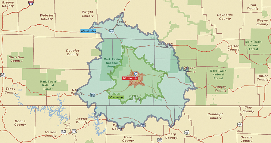
Drive-time maps provided by Community Analyst help the City of West Plains save valuable time when analyzing information to attract business to the area.
When Robert Case began his job as economic development director for the city last year, he brought with him more than 10 years of economic development and urban planning experience in both the public and private sectors. Most recently, he had been working at a private consulting firm in South Bend, Indiana.
In that position, he managed several multimillion-dollar economic development projects and developed several master and strategic plans for communities throughout the Midwest. In his new role as director in West Plains, Case is responsible for attracting new businesses, as well as encouraging expansion and retention of businesses in the city.
This is not an easy task, especially for a smaller community competing with larger-populated areas in a region. Case knew he needed to attract business to the community by providing information about the city area that would translate into risk-free opportunities organizations could take to the bank.
Competing in a Big Pond
As an active Esri user, Case took part in the offer to beta test Esri's Community Analyst product, a cloud-based Software-as-a-Service solution. "Right away, I was working with the solution, pulling up data," says Case. "It was so much easier to have information readily available for the areas around West Plains, instead of having to research and pull up data from the census and manipulate it into something that would make sense for a marketing program."
Community Analyst is an online GIS application, delivered as a service via any browser. It is specifically designed for government agencies like the West Plains department of economic development. While the city has a lot of GIS experience, the solution can also be used by organizations that have little or no technical GIS experience. Further, since the application is hosted in the cloud by Esri, Community Analyst customers need not be concerned with allocating and maintaining supporting hardware or installing additional software on the premises.
Through the online data and mapping tools, Case is able to quickly explore the geographic characteristics of any area and develop the right strategies for attracting more business in his community. Case and his staff have access to thousands of demographic, health, economic, and business data variables that help them discover patterns, relationships, and trends and analyze unique community characteristics for their geographic region.
Esri's Tapestry Segmentation Profile data is also included and provides insight into particular types of people who live in each neighborhood, including demographic and socioeconomic characteristics and preferences. This type of detailed information, such as what TV shows people watch or what magazines they read, is invaluable in assisting businesses to understand who is living in the area and what their preferences are.
Case creates maps and reports that provide information that is useful to the commercial developers he is working to attract. Pertinent data like that described above is used by retailers, offices, and light-manufacturing organizations to make the sound decision to relocate in West Plains.
Geodemographic Data—A Real Eye-Opener
Perhaps the biggest eye-opener for Case and the commercial developers he works with was the data counts provided for regions around the city. The 2000 Census population for the City of West Plains was 10,866. Since the data available through Community Analyst is Esri Updated Demographic data for 2010/2015, it has more accurate counts. The demographic data is built on Census 2000 and updated annually to give current-year estimates and five-year projections for categories including population, households, income, and housing.
"When we pulled up ZIP Code data for the city, we found that the population counts were in fact almost double what the 2000 Census counted," says Case. "When I showed this to the developers, we started getting a little more interest in the community, even during such a sour economy."
Being able to map this information was a big positive for this rural community. "Having access to this data was a definite benefit," continues Case. "Many times, it is difficult to get updated information for rural areas like ours outside a larger metropolitan statistical area."
Saving Time
Community Analyst also comes with customized drive times and rings that can be selected to find out even more about the types of people who live in a particular area. "While some might think that one-, three-, and five-mile drive times are archaic, this kind of travel data is so important for the organizations we are trying to attract to the area," says Case. "If we were to do this ourselves, we would have had to build quite an interesting model to figure this out, and it would have taken some time. Having this readily available saved staff time and taxpayers' money."
For more information, contact Robert D. Case, economic development director, City of West Plains, Missouri (tel.: 417-256-7176, e-mail: development@westplains.net).
Related Podcast
Geography Enhances Business Intelligence
Allan Pym, vice president of sales for APOS, explains how geospatial technology integrated with business intelligence systems greatly improves market analysis. Listen to the podcast. [8:00 | 8 MB]