Beth Timmons
Volunteering Is Heroic
Beth Timmons
GIS professionals understand workflows, development, and technology. They are proficient problem solvers who understand how to analyze and approach a project, plan it, complete it, and educate others. Many of these on-the-job skills can be applied to helping a local organization or community better address its concerns and meet its goals. GIS volunteers apply their talents in ways that make huge differences. Esri acknowledges the work of many volunteers by highlighting one of them, Beth Timmons, as a GIS Hero.
Timmons is a full-time GIS professional employed by GeoLogics as a contractor for Natural Resource GIS in Corvallis, Oregon. She also serves in the volunteer branch of the US Coast Guard, where she donates her GIS expertise an average of 50 hours per month. Along with having expertise in soil and GIS, which is highly valued by GeoLogics, Timmons has experience and is very interested in using GIS for emergency response. She looked for opportunities with the Coast Guard to see if it needed her GIS skills. The answer was a resounding "Yes!"
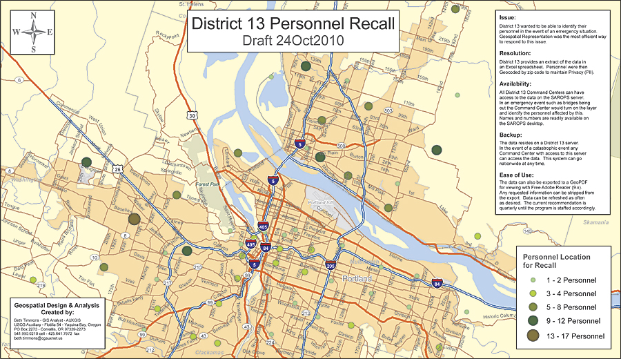
Beth Timmons is a GIS volunteer for the US Coast Guard. District 13 needed to identify its personnel in the event of an emergency, so Timmons digitized information from the Command Center's three-ring binders.
District 13 of the Coast Guard includes Idaho, Montana, Oregon, and Washington. The Coast Guard has an enterprise license agreement with Esri for ArcGIS but doesn't have the trained staff it needs to take full advantage of it. Rolling up her sleeves, Timmons began by leveraging the existing datasets to create geospatial products that staff could use on their desktops. For example, she worked with the Citizens Action Network, a group of local volunteers who have a view of waterways and can confirm problems that have been called into the Coast Guard. She digitized information from the pages of the Command Center's three-ring binder and turned these into a geospatial layer for map display. If the Coast Guard receives a distress call, the user sees the location on a map along with contact information about the nearest volunteer to call and get visual verification.
Other key projects Timmons has created are a geoenabled PDF of tribal fishing zones and a Coast Guard Auxiliary personnel locator; the latter is used should members be in a disaster area and need assistance. She also mapped accidents and fatalities in inland lakes and waterways to show Coast Guard personnel the most dangerous locations. Her crab trap project convinced people not to lower traps into the shipping lane. Traps get caught in propellers and rudders and jam steering mechanisms. Overlaying a nautical chart with Oregon Department of Fish and Wildlife data, she created a map that shows that the best crabbing spots are actually outside the channel.
The benefits to the Coast Guard staff extend far beyond the maps Timmons has produced. She has saved it money by explaining how to use its existing system to solve a problem rather than buy new technology. One of her roles has been to train staff members to use ArcGIS on their desktops. Her teaching process is first to create a geoenabled PDF so that staff can get accustomed to a GIS map using familiar Adobe Reader skills. Once they are comfortable, she moves them to ArcGIS Explorer or ArcReader. The next step is working with them to use GIS. Coast Guard personnel move every few years. Timmons not only trains new people who rotate into a position; she also provides stability to the organization. Moreover, the people she has trained take these skills to their next assignment. They may even become GIS evangelists at their next assignment, saying something like, "In District 13 we could just turn on this layer and do such and such."
GeoLogics, where Timmons works, also benefits from her volunteerism. "On my volunteer projects, I get to do GIS the way I want to do GIS," says Timmons. "Working on these projects has increased my GIS skills because I have had the freedom to explore other options and come up with a better way of doing something. I have learned what works and what doesn't. This makes me a better employee. I can say, 'I can do that because I have already done it for a volunteer project.' The proof of concept has already been completed."
A self-proclaimed volunteer freak, Timmons contributes to the Oregon Framework Implementation Team for Emergency Preparedness, the Region 10 Regional Response Team for Oil Spill Response, and the West Coast Regional Ocean and Coastal Data Framework for Ocean and Coastal Health. She also started a local GIS user group. A few years ago, she got together with some other GIS users at the local pizza restaurant to talk about GIS. This GIS social continues to be a regular event that gives local users an opportunity to learn from their peers, share tips and tricks, and get advice.
Timmons enjoys her natural resource GIS day job but says that it is hard to ask a job to be 100 percent fulfilling. She finds her volunteer work to be highly gratifying and encourages other professionals to get involved locally.
Timmons offered suggestions for getting started as a GIS volunteer in a local community:
- Join the US Coast Guard Auxiliary and become part of its GIS team.
- Attend a city council meeting and listen for opportunities to use GIS skills.
- Reach out to small cities that don't have a GIS and offer assistance.
- Do a simple project, such as mapping culvert locations using existing data. Create the PDF and send it to the department's manager.
- Talk with the fire department. Perhaps you can help improve its response system.
- Check in with city or county park departments. Put a department's data layers over a basemap from ArcGIS Online and give park staff a planning map to post on a wall.
"I believe everyone should volunteer at some level," Timmons says. "We can use our GIS skills to do even a tiny project, such as overlaying flood zone data on the town's topography and creating a PDF. It could make a big difference."
For more information, contact Beth Timmons (e-mail: beth.timmons@gmail.com).