Charlotte Fire Department Links Live Data, Multiple Systems
Real-Time Fire Response
Highlights
- Built on ArcGIS for Server and ArcGIS API for Flex, COBRA allows a wide range of staff to effectively respond to events.
- With GIS, commanders can view real-time data and everything they need to monitor the event and respond to an emergency.
- COBRA displays medical and nonmedical events on a digital map interface with other supporting data.
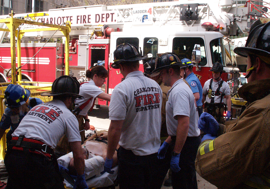
Uptown Charlotte rescue. (Photo courtesy: Charlotte Fire Department.)
The City of Charlotte, North Carolina, is the state's largest metropolitan area. It is the 18th largest city in the United States, covering approximately 300 square miles. The Charlotte Fire Department (CFD) has a rich tradition of fire service. It maintains 42 fire stations and serves approximately 700,000 citizens. CFD responded to more than 93,000 calls last year.
CFD has spent years building geospatial databases that supply data for every type of workflow. Simply put, GIS impacts the entire organization and its fire service operation. From preplanning to response to emergency management, Esri software has improved how the agency operates.
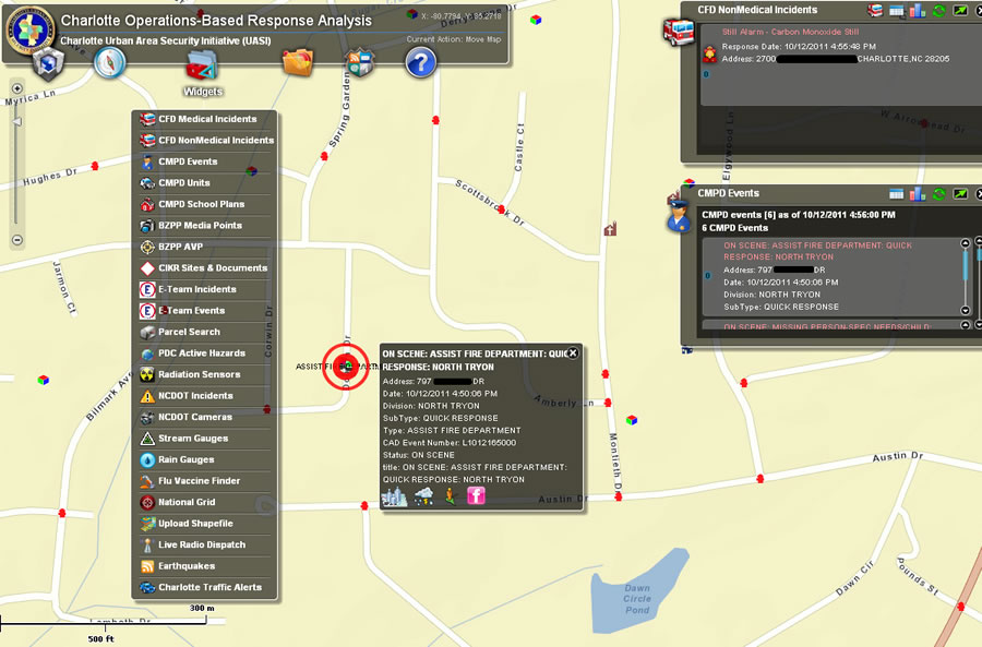
The agency now deploys the Charlotte Operations Based Response Analysis (COBRA) system as an effective common operating picture (COP). COBRA is a web application, built on ArcGIS for Server and ArcGIS API for Flex, that allows different people—commanders, first responders, search and rescue personnel—to effectively respond to events. The application links a rich array of information to a digital map overview of the county and surrounding areas. Due to cross-agency and cross-system integration, it supplies a single solution for accessing a number of tools. COBRA is used in various capacities because of the flexible, role-based, secured access system. Different roles are assigned access control to appropriate map layers and functionality.
All of CFD, the Charlotte-Mecklenburg Police Department, and many federal and military branches can take advantage of COBRA. Moreover, it will be used during the Democratic National Convention, which will be held in Charlotte starting September 3, 2012.
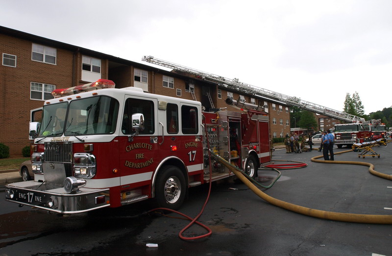
Three alarm at Charlotte apartment complex. (Photo courtesy: Charlotte Fire Department.)
"COBRA removes boundaries," says Bridget Hayes, GIS manager, Charlotte Fire Department. "We have current traffic, rain gauges, weather, fire, police, and emergency management feeds on top of a basemap supplemented with local data. The basic premise of hosting all this data and formats on one platform is extremely powerful."
A Leading Public Safety Agency
CFD has teams that can be assigned to missions anywhere in the state of North Carolina and regionally within the southeastern United States. The Charlotte-Mecklenburg Office of Emergency Management (CMEMO) is also a division of CFD and maintains the Emergency Operations Center. CMEMO serves more than 900,000 residents countywide and covers approximately 300 square miles.
The deployment of a single, comprehensive system began with the recognition that the city and the county used different data maintained independently. This data was critical for responding to major incidents and performing a number of mitigation and daily operations, but it was not immediately available across governmental lines or even between divisions. In addition, commanders and fire staff needed different applications, viewers, and systems to get the information they needed, which was an obstacle to efficiency. The challenge was to quickly and effectively access these diverse datasets that were maintained in multiple locations. There was no single solution for viewing and analyzing data. For example, homeland security data and documents were collected on behalf of the Charlotte Urban Area Security Initiative, yet there was no specific application to host them. Some systems are critical to their respective area, such as computer-aided dispatch (CAD) maintained by fire operations or NC4's E Team incident management system that was used by CMEMO. However, when a major emergency strikes, an incident commander is hindered by the need to log in to each system separately.
COBRA was built to supply real-time fire "at-a-glance" response coverage based on network drive-time analysis of fire engines and fire stations.
CFD was familiar with ArcGIS and knew that the software offered a streamlined approach for seeing all its data in a common operating picture. Realizing that ArcGIS could be harnessed to overcome this big problem, the agency got in touch with Esri Professional Services to assess its needs, identify areas of workflow improvement, and outline a strategy for overcoming its data challenges. CFD GIS staff needed a way to broaden data access from within its ArcGIS for Desktop environment. Coupling the desktop environment with the power of ArcGIS for Server served a dual purpose: the sharing of GIS datasets with rich application data. After some months of development, COBRA was built and deployed.
COBRA
COBRA was built to supply real-time fire "at-a-glance" response coverage based on network drive-time analysis of fire engines and fire stations. People can also view real-time 911 fire incidents and vehicles responding to those incidents using CFD automatic vehicle location technology. Documentation is available that includes critical infrastructure, building plans, safety documents, evacuation plans, and school floor plans, along with maps, photos, and virtual tours.
In addition to viewing fire data, the system is linked to the Charlotte-Mecklenburg Police Department's vehicles and events. For a comprehensive emergency situation, fire commanders can see police incidents and their unit locations and vice versa.
With COBRA, fire commanders can see police incidents and their unit locations and vice versa.
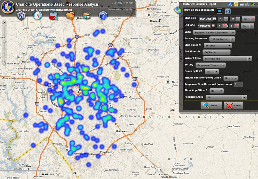
With the system, staff at multiple levels of the organization can perform advanced analysis and reporting of historical and current data. For instance, CFD runs various reports to present its historical performance. These are complex reports that influence future decisions (e.g., incident response time analysis, streets affecting response times, arson analysis, station location). In the past, these reports were run based on a set of criteria, geocoded, and then displayed on a map. Sometimes additional spatial or network analyses were performed as well. This process generally took hours. These same reports are now run through COBRA and geocoded within a matter of a few seconds.
COBRA displays medical and nonmedical events on a digital map interface with other supporting data, such as incident type, responding units, and cumulative time on scene. The supporting data is extracted via the department's CAD data warehouse and available in near real time, giving public safety personnel the live info they need.
For instance, incident maps help evaluate response times and historical demand. This can be used to determine the best possible location for a new fire station. For daily operations, a web-based status board shows resources and coverage, including coverage gaps. Commanders can quickly relocate vehicles as incidents occur and coverage gaps result.
COBRA is particularly useful for event management. Real-time data is instantly fed into the COP. Commanders can view everything they need to monitor the event and respond to an emergency. Weather, automated vehicle location data, stream and rain gauges, traffic cameras, social communications, and video feeds are all streamed into the web map. Command staff can take advantage of true real-time situational awareness—which is vital for large events, such as the upcoming Democratic National Convention. COBRA will help ensure that adequate fire, law enforcement, medical, and security staff are in place.
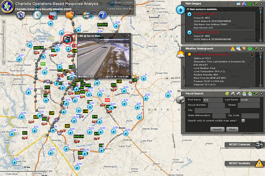
COBRA shows current traffic, rain gauges, weather, fire, police, and emergency management feeds on top of a basemap supplemented with local data.
Advanced analysis and reporting are performed constantly to help with long-term planning. Are there areas with a particularly high rate of incidents, such as automobile accidents or structure fires? Are there enough units readily available? Are there specific times when more staff are needed for a particular location? This type of analysis helps commanders identify problems early and determine what additional steps are needed. Both heat maps and cluster maps clearly and accurately convey information that's immediately understood by staff.
The system was built with security in mind. "Because we anticipated use of COBRA with other public safety partners and as a place to house sensitive data, it was imperative that security be strong for everyone's peace of mind," says Hayes.
Roles and security levels vary to allow a great deal of flexibility within the application and across various disciplines. Menus can be customized based on roles to keep the application choices concise, resulting in less training and a more intuitive approach for users.
Other examples of COP use include carrying out property searches for inspections, conducting tier II chemical assessments, and monitoring nuclear radiation sites.
COBRA also links to social media. Live social media feeds incorporated into the common operating picture allow citizen responders to upload their photos, videos, and Tweets for immediate view by commanders.
"As COBRA continues to grow, we will expand its functionality," says Hayes. "We know we have a lot of design and development behind us, but there is so much more that can be done."
For more information, contact Bridget Hayes, GIS manager, Charlotte Fire Department (e-mail: bhayes@charlottenc.gov).