Understanding Deforestation in Eastern Democratic Republic of Congo
By Fabiano Godoy, Conservation International, and Wegener Vitekere and Luc Lango, Tayna Center for Conservation Biology
Highlights
- ArcGIS is used to integrate local knowledge and science.
- GIS helps improve the management of reserves.
- ArcGIS maps the drivers of deforestation.
![]() Created in 1998, the Tayna and Kisimba-Ikobo Nature Reserves are located in the province of North Kivu in eastern Democratic Republic of Congo (DRC). Both reserves were created and are administered by the local customary powers given to the Bamate, Batangi, Kisimba, and Ikobo traditional communities, with the intention to preserve the biologic heritage and foster social development. In 2006, after dialog with the Ministry of Environment and the Congolese Wildlife Authority, the reserves were recognized, opening a new model of community-managed conservation areas.
Created in 1998, the Tayna and Kisimba-Ikobo Nature Reserves are located in the province of North Kivu in eastern Democratic Republic of Congo (DRC). Both reserves were created and are administered by the local customary powers given to the Bamate, Batangi, Kisimba, and Ikobo traditional communities, with the intention to preserve the biologic heritage and foster social development. In 2006, after dialog with the Ministry of Environment and the Congolese Wildlife Authority, the reserves were recognized, opening a new model of community-managed conservation areas.
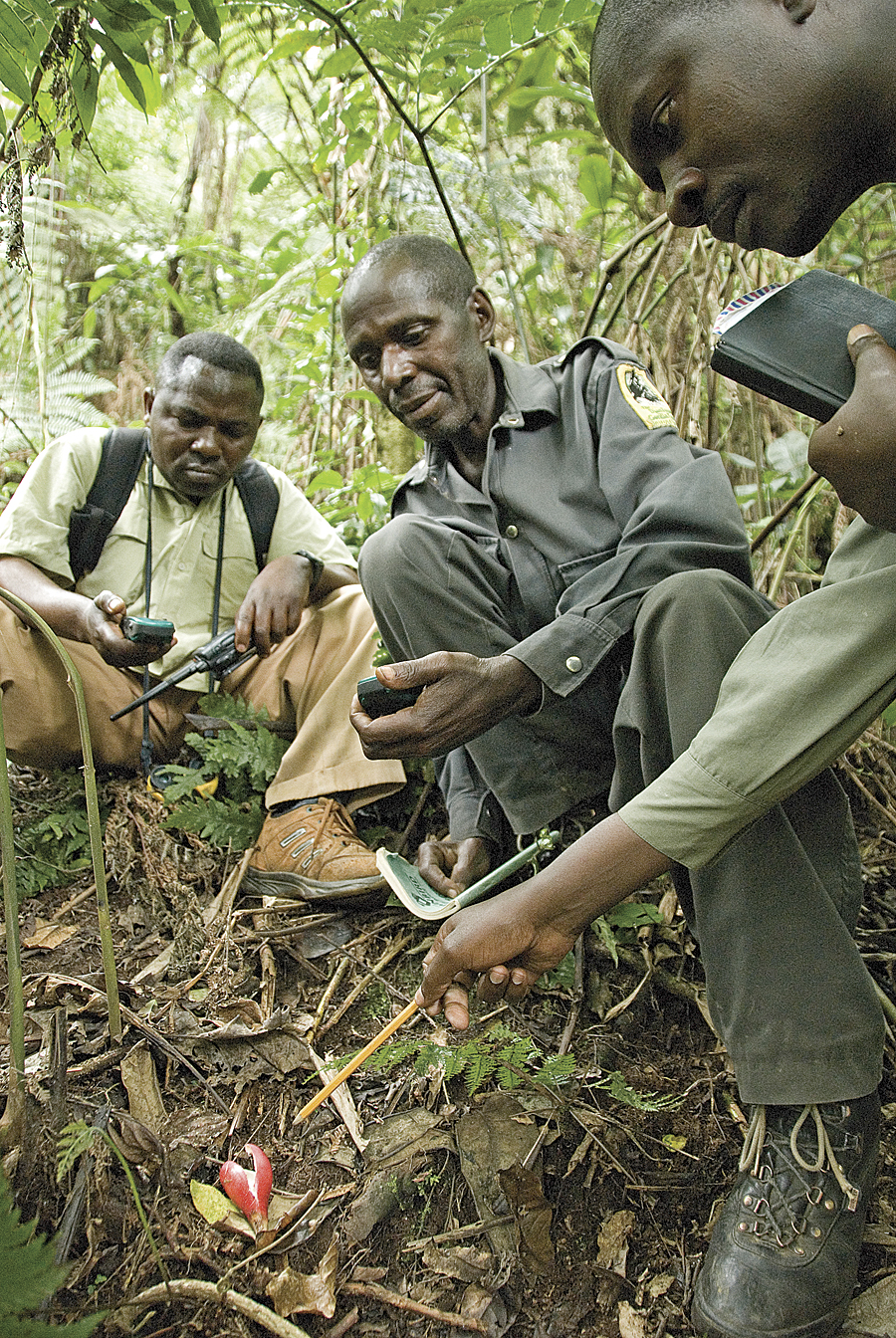
Field researchers collecting biodiversity data in the nature reserves. (Photo � CI/Photo by John Martin)
Together, the reserves cover an area situated between the lowlands of the Congo Basin and the highlands of the Albertine Rift. This area is noted for its globally significant biodiversity, containing more than 45 threatened species of fauna and flora recorded in the Red List by the International Union for Conservation of Nature. In addition, there are high numbers of endemic and restricted-range species, like the eastern lowland Grauer's gorilla (Gorilla beringei beringei), the okapi (Okapia johnstoni) and the African elephant (Loxodonta africana cyclotis). The region contains the largest remaining block of intact forest in the Congo Basin, which is at the headwaters of the Congo River and plays a crucial role regulating local and global climate and soil protection.
Despite great effort from local communities to protect the reserves, the surrounding region is under a great and imminent threat. Forest fragmentation is one of the greatest threats to the health of the environment, isolating species communities and degrading important environmental services. Local villages also rely on the natural resources, primarily firewood, fish, clean water, and plants for food and medicine.
Habitat destruction, mainly caused by forest conversion to agriculture and unsustainable logging, is advancing toward the reserves and jeopardizing the integrity of ecosystem services. According to the atlas produced by the Observatoire Satellital des For�ts d'Afrique Centrale, between 2005 and 2010, DRC lost 1,976,000 hectares of forest, the equivalent of about 1,000 soccer fields, per day. Local human population has grown in the same period, increasing the timber demand for housing materials and land for crops and pasture.
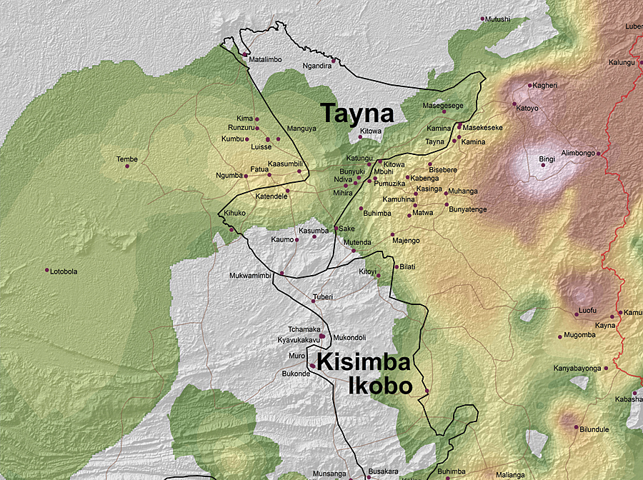
The distribution of the major drivers of deforestation in the recent past (approximately 2000-2010) was mapped based on local knowledge and validated with the actual forest cover and change imagery.
In response to these issues, the local communities have partnered with Conservation International to implement a project to improve human well-being while conserving the natural resources and the provision of ecosystem services. To better design strategies to mitigate the causes of forest loss, local leaders and experts are engaged in a consultation process to identify the main agents and drivers of deforestation in the region. They are also working to determine the correlation with the underlying causes and map the distribution of threats in the past (approximately 2000 to 2010) and in the future (approximately 2010 to 2020). Six major threats to the forest were identified: conversion to agriculture, conversion to pastureland, infrastructure/new settlements, mining, firewood collection, and illegal logging.
The data was compiled and analyzed by Conservation International, an organization with an Esri nonprofit organization site license agreement. Conservation International used ArcGIS to digitize the maps depicting the threat distribution, assign the severity in each polygon, and generate the cumulative threat map; such processing was done for past and future threat locations. Due to the subject nature of defining physical boundaries of threats, the limits of the cumulative threats were not the best representation of the results. The polygon-vector files were then converted to rasters and the boundaries smoothed. To generate the soft surface, random points were allocated over the study area, and the kriging interpolation tool was applied. Local knowledge was validated by comparing the past threat distribution map with the actual deforestation map generated by satellite imagery classification. The future threats maps will be used to validate the output from a deforestation model. "This approach was an excellent example of combining local knowledge and science, and the final product could be a very powerful management tool for the communities," says Susan Stone, senior director for social policy and practice at Conservation International.
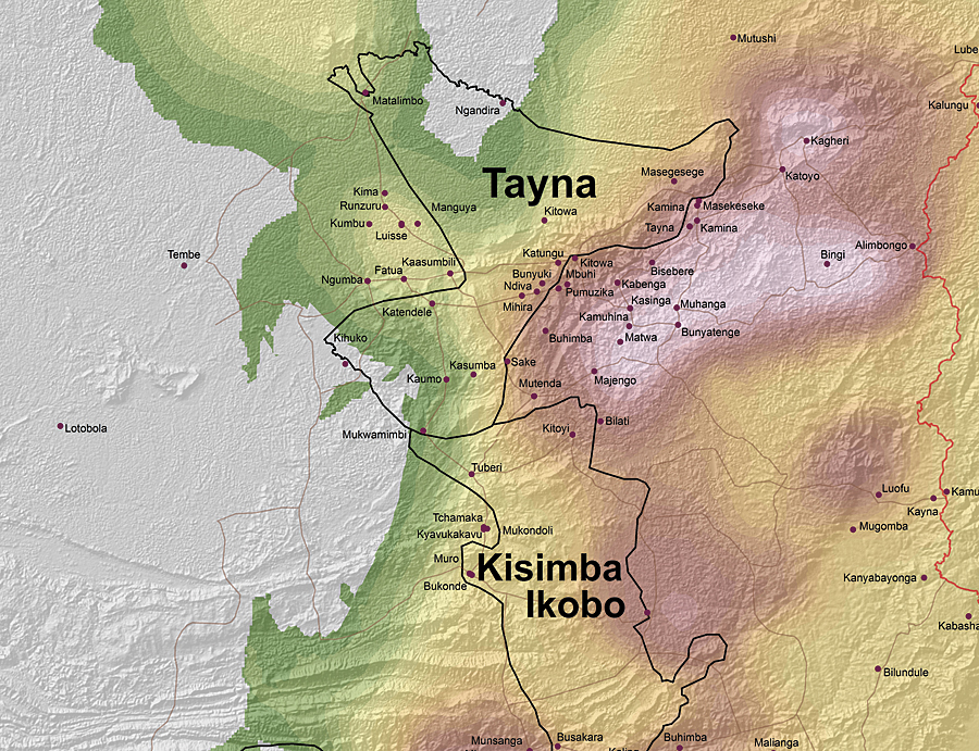
The distribution of the major drivers of deforestation in the future (approximately 2010-2020) was estimated based on local knowledge.
Information about biodiversity is currently being added to the GIS—for example, observations of gorilla and chimpanzee groups and nests that have been collected by the communities since 2002. This data will be used to measure the impact of mitigation activities on biodiversity. In addition, maps depicting deforested areas, critical areas for conservation, and potential areas for sustainable use are being used to raise conservation awareness in the community and among the students of the Tayna Center for Conservation Biology (TCCB). Wegener Vitekere, a lecturer at TCCB, highlights that "The GIS should not be considered only as a tool but also as a service that should be present in the management of a protected area and be beneficial to the people living in the protected areas."
Another output from the public consultation was a conceptual model that provides a comprehensive overview of the causes and illustrates the relationship between contributing factors and deforestation. Together with the threat maps, the conceptual model is being used to identify key areas to implement mitigation strategies, as well as to define expected impacts and establish a monitoring system.
About the Authors
Fabiano Godoy is a cartographic engineer with an MSc in sustainable development and conservation biology. He has been working at Conservation International since 2006 developing deforestation models. Wegener Vitekere has been a junior lecturer and researcher at the Tayna Center for Conservation Biology since 2010. Luc Lango is from the Batangi community and since 2008 has been working as research manager at Tayna Center for Conservation Biology. He holds a BSc in ecology and animal resources management.
For more information, contact Fabiano Godoy, Science and Knowledge Department, Conservation International (e-mail: fgodoy@conservation.org).