Winter 2001/2002
Winter 2001/2002 |
|||||||
|
|
|||||||
Groundbreaking California Site Migrates to Esri's Next Generation Technology
Elsinore Valley Municipal Water District Goes Live with ArcGIS |
|||||||
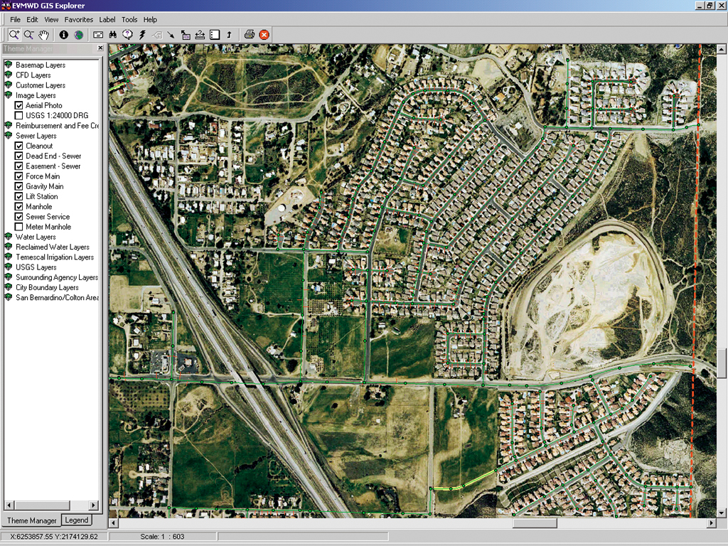
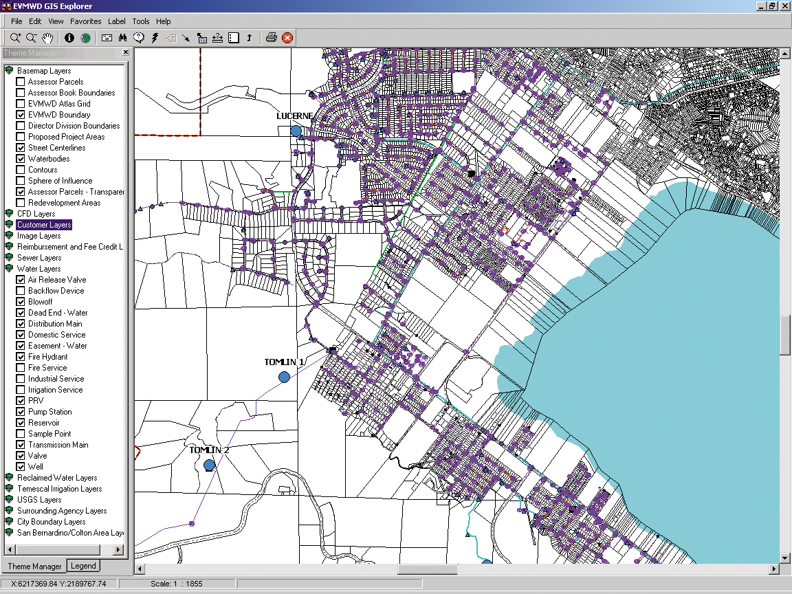
The case for advanced GIS isn't just for large-scale operations. Mid-sized and small utilities are using GIS as a centralized information resource for a wealth of application needs. Elsinore Valley Municipal Water District (EVMWD) successfully migrated to Esri's ArcGIS software and now uses the component-based, open architecture for its diverse utility needs, all in an enterprise environment. An Esri GIS user since 1992, EVMWD successfully completed its migration in Q4 2000 after a quick eight-month conversion process. GIS data conversion included 5,000 as-built drawings, 300 atlas pages, and virtually all manually produced map and related tabular documents. "Using a common geodatabase and providing powerful tools to our many diverse users empower our utility to work more efficiently and with greater success," says James A. Ollerton, GIS manager, Elsinore Valley Municipal Water District. "We've achieved tremendous accomplishment using GIS tools in the past, and we feel that ArcGIS will provide a foundation to continue to develop powerful solutions for our needs today and into the future." Elsinore Valley Municipal Water DistrictFounded in 1952, Elsinore Valley Municipal Water District employs 150 people and provides approximately 25,000 water, wastewater, and agricultural services. The company is based in the City of Lake Elsinore, California, and maintains an infrastructure consisting of 305 miles of water pipelines, 290 miles of sewer pipelines, and 246 miles of irrigation pipelines. The company uses ArcGIS, including ArcInfo 8.x Professional GIS, ArcView Desktop, MapObjects Developer GIS, and ArcIMS for Internet GIS. ArcPad is used by field-workers as an easy-to-use, lightweight solution for mobile mapping of utility assets and infrastructure. Its online system, known as EVMWD GIS Explorer, was developed using MapObjects and Visual Basic and provides customized GIS analysis and visualization of utility assets and customer data. The enterprise GIS is used in 15 departments including engineering, finance, operations and maintenance, customer service, and more. At EVMWD, ArcGIS runs on SQL Server 7 relational database management system software, with the Visual Basic 6 development environment and Windows 95/98 and Windows NT 4 operating systems. Windows 2000 Workstation and Windows 2000 Server software are also deployed. The hardware consists of Gateway 7400 and XI NetRAIDer servers and various Pentium III workstations. The servers are the machines with the dual 800 MHz processors. With approximately 35 users accessing and maintaining the GIS database with 25 gigabytes of data, the enterprise solution is not only boosting efficiency but also saving the utility money.
"Running ArcGIS on the Microsoft platform has saved us money on software and hardware costs," says Ollerton. "It fits in the District's standardization on Microsoft operating systems and Microsoft products in general." The decision to adopt ArcGIS came after the utility tested and worked with the software as an Esri beta tester. "The seamless database and the ArcMap editing environment were two compelling reasons why we wanted to migrate," says Ollerton. "We had been using SQL Server for a couple of years to store all property information and feature attributes. In 1998 we evaluated ArcSDE 3 on SQL Server and were impressed with the ease of setup and the performance. ArcSDE 8 has worked excellently with SQL Server." ApplicationsToday, the utility uses a seamless database for all water and wastewater facilities, with a complete and detailed inventory of all assets. In addition, GIS is used for dozens of applications. For instance, in finance, standby assessments, pressure zone charges, and reimbursement agreements are managed using GIS. A finance user can quickly locate facility assets and link customer account information to determine connection fees. Operations personnel use GIS for creating atlas maps, facility locations, asset maintenance and replacement, and assistance with its DIGALERT Calls system. At EVMWD, pipelines are located in very rural areas. At the time the pipelines were constructed, there were no accurate records of their location. The paper records that did exist were stored in a water-assets atlas, which was estimated to contain just 18 percent of all utility asset infrastructure. GIS gives EVMWD to manage operations-related data. More than 75,000 maps are maintained in the fully digital, enterprise GIS environment.
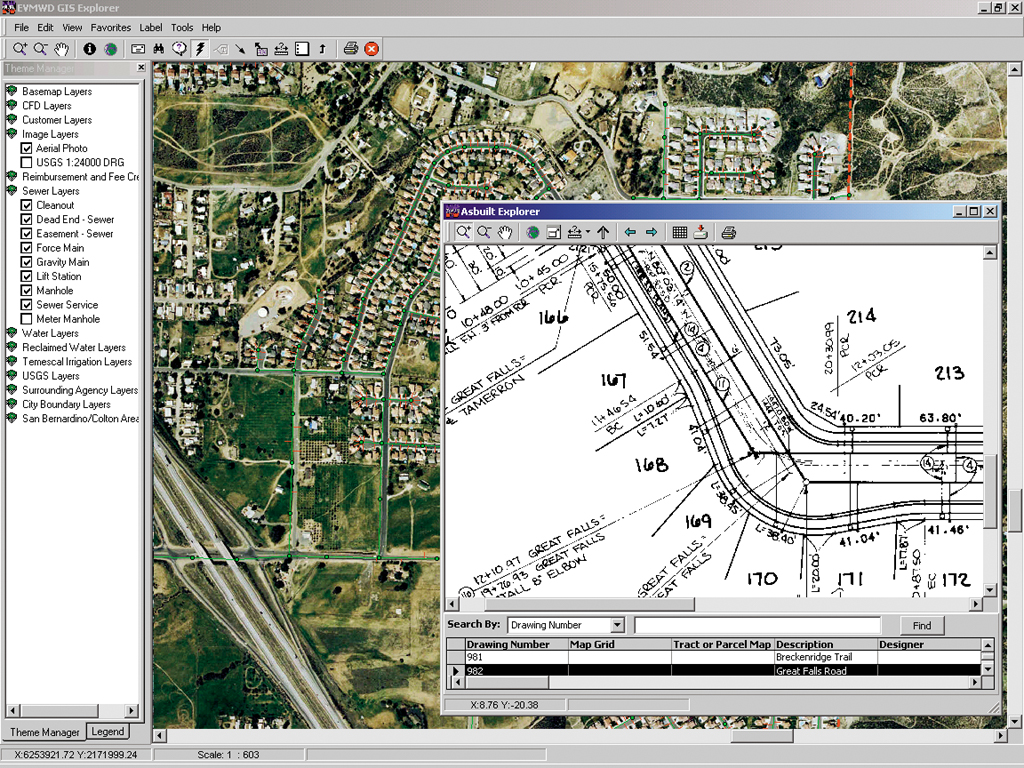
Customer service uses GIS for meter reading route analysis, meter location, and identifying illegal connections. If a customer call comes in, a service representative can go online using the company's EVMWD GIS Explorer to access customer and utility information with just a few mouse clicks. Engineering uses GIS for verifying water or sewer availability, planning, inspection assistance, and generation of as-built drawings for internal projects. The benefits of recording and storing as-built construction drawings are the ability to digitally store and archive the utility's entire record drawing inventory and direct access to the source document, also via the EVMWD GIS Explorer. Additional applications have been deployed under the ArcGIS platform. Demographic and land use analyses give the utility a more effective means for planning new construction and maintenance of existing infrastructure, as well as provide for a means of anticipating future growth. Supplanting paper mapmaking methods, GIS is used to redistrict current zone areas and to calculate zone charge audits. Standby charge assessment and water and sewer modeling are performed as well. "Getting GIS ingrained into our corporate infrastructure gives us a leading edge in doing our Business," says Ollerton. "From a water superintendent accessing pipeline statistics to a general manager researching potential land purchases, there are countless ways this technology can be used. Whether it's to automate information management, provide advanced query and data analysis capabilities, or visualize information, we're operating with greater efficiency and significant cost benefit using technology that is based on IT standards, meaning we have an investment that's here to stay." "Elsinore Valley Water District is a leading GIS user, and their success as a medium-sized water/wastewater utility demonstrates that utilities and municipal organizations of any size can use GIS technology to improve their Business and better serve their customers," says Chris Thomas, local government industry solutions manager, Esri. "Whether it's using ArcGIS, ArcIMS, or ArcSDE, utilities and other organizations are taking notice of Elsinore's outstanding achievement. Their system lowers costs, increases productivity and efficiency, and enhances service." For more information, contact James A. Ollerton, GIS manager, Elsinore Valley Municipal Water District (e-mail: ollerton@evmwd.dst.ca.us; tel.: 909-674-3146, ext. 277; fax: 909-674-7554; Web: www.evmwd.com). |