Winter 2001/2002
Winter 2001/2002 |
|||||||
|
|
|||||||
GIS Day 2001--Another Global Success |
|||
|
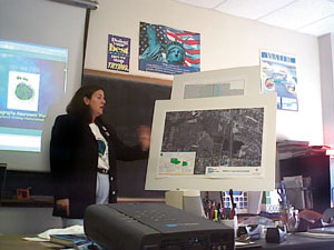
Events Around the WorldThe Louisville Science Center in Louisville, Kentucky, hosted a special Geography Day on Wednesday, November 14, in honor of Geography Awareness Week (November 11-17). Guests were invited to talk with specialists giving demonstrations on the latest real-world applications of geographic technology. Some guests even tested their geography knowledge by taking part in the Geo Bee. All guests were invited to participate in this contest that took place in the Chemistry Kitchen. The Science Center also broadcasted a live "Meet the Experts" TeleLink in the Tech Forum Theater. Panelists included experts from the U.S. Army Corps of Engineers, the University of Louisville, the Metropolitan Sewer District, and Spatial Data Integrations, Inc. Eotvos Lorand University in Budapest, Hungary, held a presentation using multimedia and maps. The duration of each presentation was about 15 minutes and the topics included cartography, digital atlases, and GIS. This exhibition presented the maps made by children for the Barbara Petchenik Award, which this year was organized by the International Cartographic Association. For more details and to view pictures, visit www.gisday.com/success2001/event4159.html. The Olathe Fire Department in Olathe, Kansas, visited each third grade classroom in the City during Geography Awareness Week. This was an effort to reinforce basic map skills and emphasize the importance of geography. The fire department also introduced the students to the GIS concept. An ArcView custom map was designed for each school. Each child had the opportunity to place a small (self-decorated) wooden house on the map and locate various attributes such as fire hydrants, schools, and fire stations. It took all 80 of the City's firefighters to reach out to the 1,500 third graders.
McMaster University, School of Geography and Geology in Hamilton, Ontario, Canada, hosted a successful GIS Day for hundreds of local area high school students and teachers. The Faculty of Science and the School of Geography and Geology sponsored the third annual GIS Day celebration as part of their GIS High School Outreach Program. John Drake, acting dean of the Faculty of Science, said the GIS High School Outreach Program serves to teach, improve, strengthen, and promote GIS and science to high school teachers and their students. "GIS Day exposes many high school students to new and interesting applications of science and assists teachers in adopting new technology to bring to their students in the classroom," says Drake. "This also assists in fulfilling the new Ontario geography and geomatics curriculum and encourages high school students in further scientific study." The day's events included hands-on workshops in GIS and geomatics and a map gallery featuring GIS multidisciplinary applications in the local area. A GIS poster competition was also held. All of the hands-on tutorials were filled to capacity with more than 300 local high school students and teachers participating. The tutorials consisted of Introduction to ArcView, Intermediate ArcView and Remote Sensing, and Introduction to Remote Sensing using the Geographer's Tool Bench. The map gallery featured displays from the new City of Hamilton, the Town of Oakville, the Grand River Conservation Authority, the McMaster Institute of Environment and Health, and the Royal Botanical Gardens. The Community Planning and Development Department at Project T.O.O.U.R (Teaching Our Own Understanding and Responsibility), Inc., in Baltimore, Maryland, gave residents a tour of the four neighborhoods that are under the umbrella of Project T.O.O.U.R. Participants in the Youth Volunteer Corps of Greater Baltimore, Westport Academy, and Boy Scout Troup #348 prepared maps showing changes in the community through its history and current issues regarding industry, vacant buildings, and historic places in the community. Residents had an opportunity to give input on what they would like to see happen. The Geography and Resource Development Department in Legon, Accra, Ghana, held a general geography/GIS awareness event. All spatial data users and environment-based institutions were invited to participate. An open forum was held in which schools and Businesses participated. There was also a float with banners that paraded through the principal streets in the City of Accra. The NASA/UL Lafayette Regional Application Center in Lafayette, Louisiana, held an event entitled "Discovering Acadiana through GIS" (Acadiana is the home of the descendents of the Acadians, who settled in southwest Louisiana), which was sponsored by C.H. Fenstermaker and Associates, NASA/UL Lafayette Regional Application Center, John E. Chance and Associates, and the USGS National Wetlands Research Center. The event showcased GIS activities in Lafayette and surrounding communities and also featured a map gallery, presentations of local interest, demonstrations of area projects, and an interactive GIS lab. In Beirut, Lebanon, the United Nations Development Programme (UNDP) and Khatib & Alami-Consolidated Engineering Company (K&A-CEC) organized a conference on "Geography and the Conservation of Natural Resources" on GIS Day in the main conference room at the U.N. House between 9:00 a.m. and 2:00 p.m. Speakers from various organizations introduced the use of GIS for the conservation of natural resources to a diverse audience. The event hosted approximately 150 experts and activists from local and international official organizations, nongovernmental organizations, and academia. They shared their knowledge and technology and showcased their projects. The Science Museum of Minnesota, located in St. Paul, Minnesota, presented "Visions of Our Planet's Atmosphere, Land & Oceans: A Special GIS Day Event" as part of national Geography Awareness Week (cosponsored by the Minnesota GIS/LIS Consortium). All were invited to travel the world from a comfortable chair in the Omnitheater at the Science Museum of Minnesota. The museum, in partnership with NASA, was pleased to present NASA's electronic theater presentation featuring the latest satellite data visualizations projected onto the Omnitheater's 60- by 90-foot screen. Guest presenter, Dr. Fritz Hasler, of the NASA Goddard Laboratory for Atmospheres, narrated the presentation and answered questions. GIS Day Web CastOn November 14, 2001, Sun Microsystems, Inc., and Esri hosted the first GIS Quest! GIS Quest is a one-of-a-kind, free, interactive Web cast that enabled participants to experience firsthand the power of GIS technology. Players visited multiple, live GIS powered Web sites and learned more about the substantial contributions that GIS technology is making in their communities. No prior GIS knowledge was necessary, and game material was suitable for children ages 12 and up. GIS Quest was available for play on GIS Day and will remain at www.gisquest.org. "Sun provides a wide range of hardware and Internet solutions to support GIS computing," says Michael Cosentino, geospatial market development manager for Sun Microsystems, Inc. "We have developed GIS Quest as a unique way to effectively communicate the benefits and significance of geospatial technology." Sun Microsystems, Inc., recently joined this educational mission as a principal sponsor of GIS Day. GIS Day is principally sponsored by the National Geographic Society; the Association of American Geographers; the University Consortium for Geographic Information Science; the Library of Congress; the U.S. Geological Survey; Sun Microsystems, Inc.; and Esri. Thank you for once again helping us celebrate how geography and GIS help your communities! Be sure and check out the great GIS Day T-shirt photos at www.gisday.com/tshirt-feature.html. GIS Day 2002 is scheduled for Wednesday, November 20. Please check the GIS Day Web site (www.gisday.com) to learn more about upcoming plans and register to host a GIS Day 2002 event. |
 November 14, 2001, marked the third annual global GIS Day event. During GIS Day 2001, millions of children and adults were educated on the benefits of geography and the role that GIS plays in support of geography. More than 80 countries held GIS Day events as well as all 50 states within the United States. The following are just a few examples of the many events that were held around the globe as organizations in dozens of industries came together to introduce GIS to the world.