Winter 2001/2002
Winter 2001/2002 |
|||||||
|
|
|||||||
Telecommunications in Saint Lucia
Mapping a West Indies Paradise with GIS |
|||
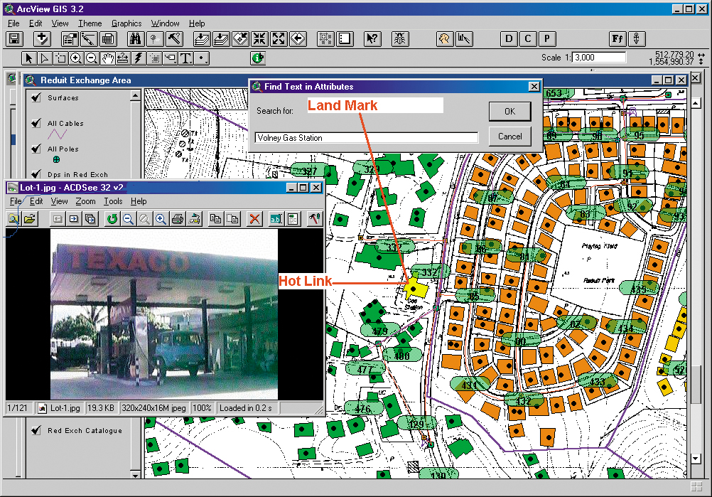
Saint Lucia is an idyllic paradise nestled in the West Indies. Its history is much like that of its island neighbors. Saint Lucia was first settled by Arawak Indians around 200 A.D., though by 800 A.D. their culture had been superseded by that of the Caribs. These early Amerindian cultures called the island first "Iouanalao" and subsequently "Hewanorra," both of which mean "Island of the Iguanas." By mid-eighteenth century the French had arrived and had even "purchased" the island for the French West India Company. Needless to say, the persevering British were less than enchanted with this idea, and the Anglo-French rivalry for the island continued for more than a century and a half. The island's first settlements and towns were all French, beginning with Soufriere in 1746. By 1780, 12 settlements and a large number of sugar plantations had been established. Two years earlier, the British launched their first invasion effort at the "Battle of Cul de Sac." By 1814, after a prolonged series of enormously destructive battles, the island was finally theirs. Gaining its independence from England in 1979, Saint Lucia has developed into a stable and increasingly prosperous commonwealth country. As with most countries with small, close-knit populations (about 150,000 residents in 238 square miles), the concept of street addresses is completely foreign. Landmarks are the traditional means of island navigation. Initial utility installation and other infrastructure were generally implemented on an ad hoc basis, which resulted in poor documentation and subsequent difficulties in modernizing existing systems.
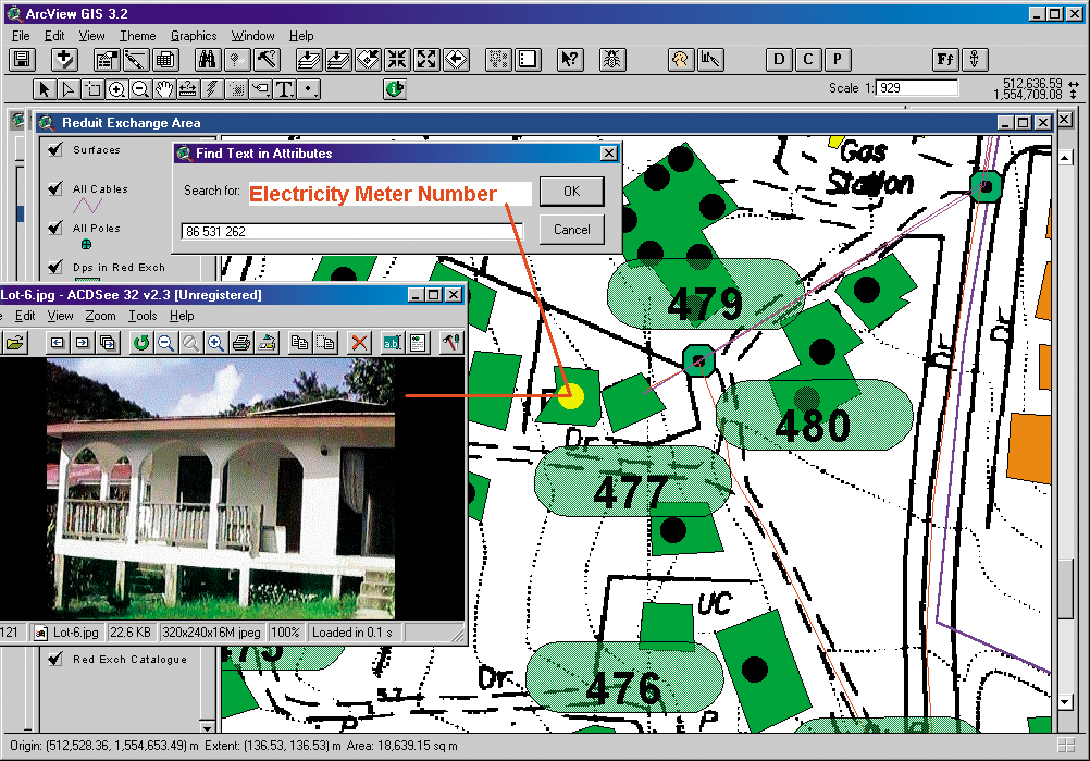
To explain how the system works, service representatives use computers to display a map of the island on their screens. Then they ask the customer which area of Saint Lucia they live in. Next, the representative clicks on the landmark table for that area. This highlights the area on the displayed map and allows the representative to use the hot link feature in ArcView software to quickly access a larger scale map that displays all residences in the area and the related distribution points. The customer examines this map to further refine the search. Once the customer identifies the area on the map in which he or she resides, the representative displays the photos of various local properties until the customer recognizes his or her home. The representative then finds the nearest distribution point and clicks on it to display an identifying table. The table is Structured Query Language (SQL) stringed to the customer information database, which provides the representative with the number of spare cable pairs available at that point. The representative can then tell the customer whether or not a network is available near the home and how long it will take to provide telephone service. The system took about 18 months to fully implement and has helped reduce time spent providing services by 87 percent in some areas. Based on its success, similar systems have been implemented in each of the 10 other Caribbean countries in which C&W operates. Comments John Wood, regional GIS manager for Cable and Wireless, "We believe that after implementing GIS in all 11 of the countries where we provide telephone service in the Caribbean, we will have taken the first steps toward a national GIS for the region. Government agencies, as well as electric and water utility companies of Saint Lucia, have all expressed great interest in this possibility." For more information, contact John Wood (e-mail: john.wood@cwslu.cwplc.com, tel.: 758-453-9835). |