Winter 2001/2002
Winter 2001/2002 |
|||||||
|
|
|||||||
Meet Rudy and Gus Mouse!
Middle School Students Put GIS to Work |
|||
|
By Anne R. Wager, Benchmark Associates, LLC, Seattle, Washington
The adventure begins in Seattle, Washington, at Lakeside Middle School, where a team of sixth grade teachers, including Scott Jamieson in the Science Department; Alicia Hokanson in the English Department; and Peter Hayes, Ecological Studies coordinator, has undertaken the task of helping students understand an urban local watershed and ecosystem. They wanted a creative approach to get students to think about the problem of a fragile ecosystem in a local way with a local ecology. According to Hayes, "It is important for our students to develop the skills of understanding land as an interdependent community and get in the habit of paying close attention to it." The project was originally developed as an offshoot to a community project: the Thornton Creek Project. The Thornton Creek Project was already in existence, and Lakeside was able to take advantage of the valuable resources available. These included an existing GIS with data support from the City of Seattle and King County and the support of Esri's Olympia, Washington, office and Esri K-12 Education Coordinator Charlie Fitzpatrick, who provided ArcView for use by the students.
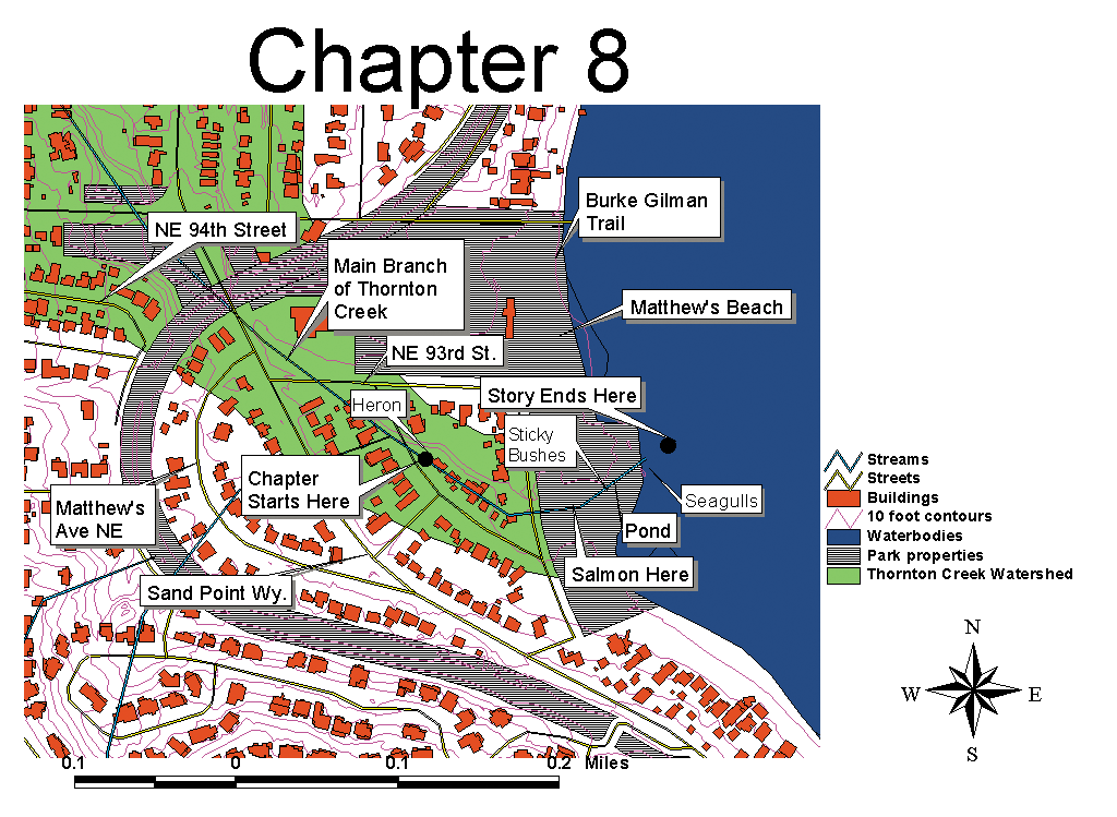
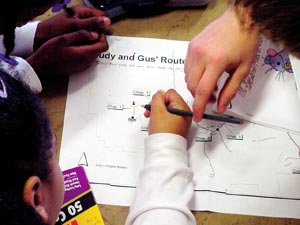
In preparation for the project, the students map their home in relation to the project site and learn the rudiments of GIS by building their commuter routes, using street coverages and color orthography to assist them in locating their neighborhoods. All of these tools combine to give them a sense of the "where" in their daily lives. Many have been surprised to find how close they lived to fragile salmon spawning areas and each other. The Rudy and Gus Project begins with sensory writing, as the students first visit the general watershed area and jot down their initial reactions to various features and their surroundings. The students are given the same basic outline so that Rudy and Gus end up in the same location after each chapter. Student teams return to each location several times, sketching, mapping, digitally photographing, writing, and observing as they proceed. Parcel maps showing where Gus and Rudy stop along the way help the students incorporate what they see into their stories. Site visits include sightings of squirrels, salmon, cats, dogs, homeless camps, diverse vegetation, and interesting water creatures, all serving as potential characters and igniting their imaginations as they weave stories of Rudy and Gus. Team-building skills are emphasized, as two students work together creating maps and familiarizing themselves with ArcView. Maps serve to enrich the telling of the stories as the students come back from each chapter site full of anecdotes that help them link each chapter and therefore each map segment to the overall watershed. From fieldwork to writing to mapmaking and final production, several components are incorporated to produce a top-quality book to share on the Web and enjoy with others. These students no longer view storm drains as just something to drive over, but as one component in a fragile and complex system. They think about the interrelatedness of these features as they discover firsthand the impacts on the water as it eventually flows to Lake Washington. For more information, contact Peter Hayes at peter.hayes@lakesideschool.org or Anne R. Wager, Benchmark Associates, LLC (arwager@bmarkassoc.com). To view recent chapters of the Rudy and Gus Project, go to the Thornton Creek Project Web site (www.thorntoncreek.org) and look for the link to recent Rudy and Gus chapters. |
 Thanks to some creative thinkers, GIS is now second nature to middle school students as they create stories of two pet store escapees--brother and sister mice, Rudy and Gus. As the two mice descend on Seattle's Thornton Creek in their trusty teriyaki dish following the watershed from its headwaters to its mouth in Lake Washington, students create fictional adventures by combining real-life fieldwork, mapping, and research skills. All it takes is reading a few of the adventures these students have written to see that understanding one's local ecosystem through GIS, research, and fieldwork can be fun.