Winter 2001/2002
Winter 2001/2002 |
|||||||
|
|
|||||||
Developing the "Broadway Corridor"
San Antonio, Texas, Uses GIS Tool for Collaborative Planning |
||
|
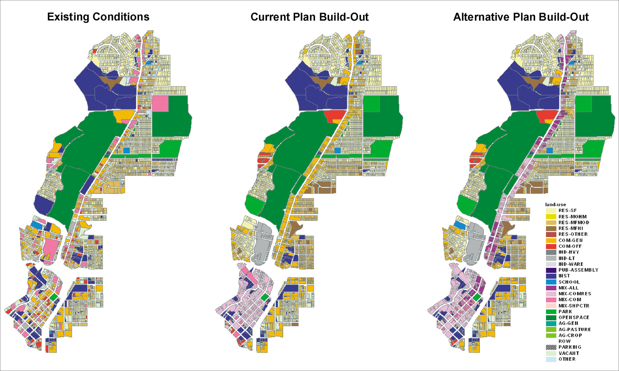
San Antonio, Texas, is widely known for its successful downtown development that brings seven million visitors annually to attractions such as the Alamo and River Walk. Four miles long, the Broadway Corridor is currently home to 12,000 residents and 13,000 workers. The area enjoys an extraordinary collection of community assets including the local zoo, botanical gardens, two museums, and a university. It also has more than 140 acres of vacant land and dozens of redevelopable properties, making it attractive for infill and economic growth.
The planning effort is distinguished by the way in which GIS brought diverse interests together to work collaboratively on a common vision for the area. In recent years, several community groups were independently looking at problems and opportunities along the Corridor. Instead, they are now jointly using GIS to find common ground. The following are examples of stakeholder interests.
The catalyst for bringing these stakeholders together was an offer from the U.S. Environmental Protection Agency (EPA) to apply Smart Growth INDEX, a GIS-based planning support tool that EPA is distributing nationally to selected communities. Smart Growth INDEX was developed for EPA by Criterion Planners/Engineers of Portland, Oregon, an Esri Business Partner, as a customization of Criterion's INDEX software series. The firm builds custom INDEX applications using Esri's MapObjects and ArcView. With help from the EPA's Dallas regional office and Washington, D.C., headquarters staff, the San Antonio stakeholders used INDEX to examine ideas and synthesize their visions and goals into a single, consensus-based plan. INDEX rates planning scenarios with a set of indicators that measure a scenario's performance in land use, transportation, urban design, and environmental terms. Example indicators include residential and employment density, walking distances to neighborhood amenities, and air pollutant emissions. According to VIA's Project Manager Lance Freeman, "This type of GIS application is a great example of how the technology can bring diverse interests together and help build consensus. Previously, we had multiple viewpoints competing for people's attention. INDEX knits these together so that people can see the sum of the parts." Working collaboratively, stakeholders completed the following activities under the direction of the local chapter of the American Institute of Architects:
A key component of the modeling was the use of ArcView Network Analyst. This ArcView extension is used in INDEX to simulate multimodal travel conditions in a study area including walking, biking, and transit. For each urban design scenario, ArcView Network Analyst is used to quickly gauge travel mode availabilities, distances, and route directness. As a result, every household and Business in the area can be accurately characterized in terms of accessibility to essential services and amenities. According to Eliot Allen of Criterion Planners/Engineers, "With Esri's help, we've been able to develop ArcView Network Analyst into an essential diagnostic tool that truly integrates land use and transportation planning at the neighborhood level." The final INDEX "report card" for the Corridor produced several important findings. First, it confirmed the area as worthy of attention for redevelopment. Of the 40 INDEX indicators, one-quarter of them already score favorably under existing conditions, and only five were rated unfavorable. Second, it showed that the current official plan for the area would lead to some, but not major, improvements over existing conditions. The number of indicators scoring in the favorable range only increased by one, and the number in the unfavorable range only decreased by one. Most importantly, it revealed that the stakeholders' new proposed plan would create much better conditions than the current plan. The number of favorably scored indicators jumped to 17, and the unfavorable count dropped to only three. In this way, the GIS tool gave participants rapid, critical feedback on the validity of their work to date and the promise of their future efforts. Following the review of initial INDEX results, organizations have continued to improve the area's database and to model additional variations of the basic concepts. Emphasis is being given to public information and agency coordination in anticipation of program and capital improvement commitments during 2002. For more information, contact Lance Freeman, VIA Metropolitan Transit (e-mail: lance.freeman@viainfo.net), or Eliot Allen, Criterion Planners/Engineers (e-mail: eliot@crit.com), or visit www.crit.com or EPA's Smart Growth program at www.smartgrowth.org. |