Winter 2001/2002
Winter 2001/2002 |
|||||||
|
|
|||||||
Swiss Cable Communications Provider Implements GIS-Based Network |
|||||||
With a service area extending to more than 1.4 million households, 300,000 signals distributed over its partner networks, and 700 local authorities making direct use of its infrastructure, Cablecom GmbH of Zurich, Switzerland, is the clear leader in the Swiss cable communications market. More than 3,000,000 people are supplied with TV and radio channels, either directly or indirectly, via the Cablecom cable networks. To maintain its market position, the company implemented a national, high-speed optical fiber backbone network stretching more than 2,500 kilometers in length. The network backbone supports a transmission speed of more than 20 gigabits per second, allowing the transmission of more than 20 million digital information units every thousandth of a second. In addition, this primary network is complemented by a complex structure of regional optical fiber networks, providing high-speed service to virtually any location in Switzerland. While Cablecom's traditional Business is broadcasting radio and television signals for local distribution, it is planning a cable network that will extend into Swiss households and provide the communications infrastructure necessary for a wide variety of multimedia services. The Cablecom backbone network is also available to third party carriers interested in providing high-speed audio, video, and data transmission services. Realizing the complexity of maintaining this extensive network, the company implemented a Network Information System (NIS) in early 2000 based on Esri's GIS software and the Telcordia Technologies (an Esri Business Partner) Network Engineer application. Cable and fiber schematics for this project were generated by FiberNet, a software product from Esri-Germany Business Partner PowerSoft R. Pian SA of Ecublens, Switzerland. The NIS provides Cablecom with the capability of documenting and managing both its backbone and local service area networks. The GIS implemented includes ArcInfo, ArcSDE, ArcFM, ArcView, ArcIMS, and ArcExplorer. This comprehensive suite of software provides a variety of powerful capabilities. At present, there are 100 people using the system for its advanced query, display, and analytical functionalities.
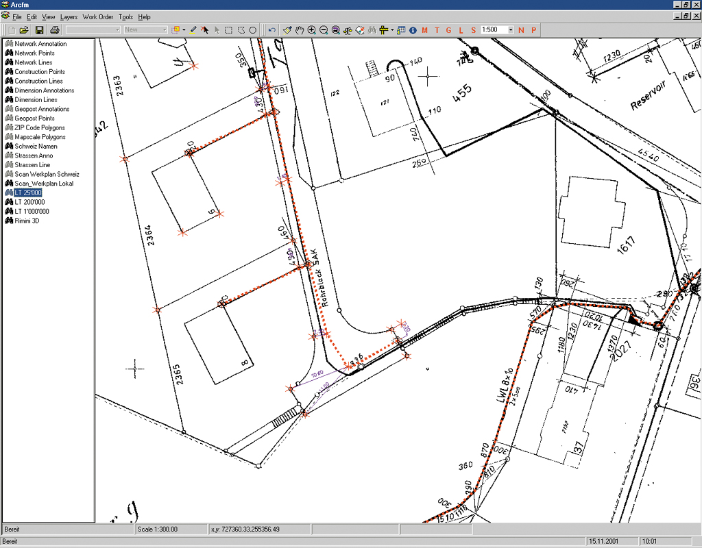
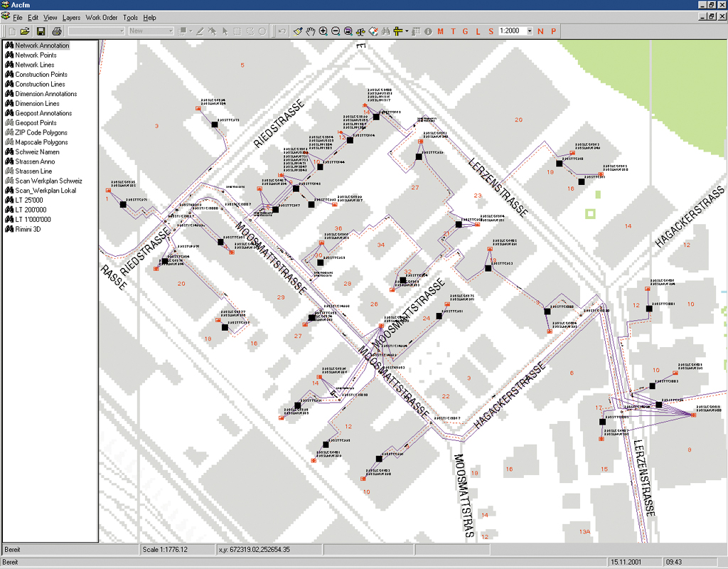
Cablecom uses the advanced tracing and graphics capabilities of a customized version of Telcordia's Network Engineer 1.2 to trace paths between connected facilities in their network and isolate problem areas within it. Observes Dominic Moser, GIS system manager for Cablecom's Network Development and Planning Department, "The customization of Network Engineer was necessary because very detailed utility network information is required in Europe. Our government asks for very accurate information regarding cable location. Very often, different utility networks are really close together or even in the same conduit. Our technical staff must document the network exactly as it is built, which makes everything more complicated. Switzerland has geocoded information for every postal address, which we use when referencing our network nodes." Network modeling functions, basic reporting, data management, and GIS analysis are all accomplished using Esri's GIS with Network Engineer. The Werkplan View
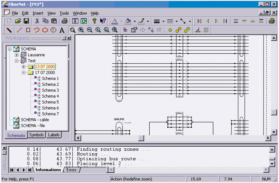
The Geo-Schema ViewThe Geo-Schema view is another customized extension. In this view, network components are captured and stored. Fiber cables are placed automatically parallel in the conduit/node network layer of the database. Splices, patch panels, and splitters are placed as nongraphic features within a group object and are referenced to the conduit nodes and related to the connected cables. Within this group item the application provides a view of the connectivity for the fiber and coaxial network. In the fiber networks, the connectivity is additionally viewed using single fiber trace functionality. The objects documented and managed in the Geo-Schema view include the conduit/node network; cables, patch panels, splitters, splices, etc.; annotation; and cadastral background information. The additional functionality provided by this customized application includes
Some of this customized functionality is already included in the new Version Network Engineer 2.0 or will be in 2.x.
Pulling information from the NIS, FiberNet generates detailed fiber schematics of the network. The choice of the main network components that have to be represented on the schema is carried out on the map view through the Network Engineer user interface. The Network Engineer/FiberNet interface then transfers this list to FiberNet. FiberNet manages saving and retrieving operations on the DBMS. "At this point, the primary use of our NIS is for technical network documentation and analysis," comments Moser. "We have very detailed telco documentation available to us through the NIS. In the future, we will be using it for some geomarketing projects. The idea is to introduce GIS to other parts of the company such as planning and marketing." Rapid changes in the cable industry, including faster hardware and software and the broadcasting of data rich in content result in higher expectations among Cablecom's customers. This in turn requires Cablecom to respond quickly and effectively to maintain its network and correct any faults as quickly as possible. "Our goal is to expand the use of GIS throughout the company. GIS allows us to make quicker decisions based on more accurate information. This allows us to better serve our users," concludes Moser. For more information, contact Nick Lindsay, telecommunications analyst (e-mail: nlindsay@esri.com, tel.: 909-793-2853, ext. 1-2690). |