Winter 2001/2002
Winter 2001/2002 |
|||||||
|
|
|||||||
GIS Users Look Forward to Full Implementation of American Community Survey
U.S. Census Bureau Focuses on More and Better Data |
||
|
With each decennial census, the content of the statistics that the Census Bureau collects, which is enormously useful to the GIS community, has become increasingly large and extensive--a necessity for helping people understand what is happening in the country and to give them a basis for planning. The Census Bureau's newest data collection program is producing data that can be used in GIS applications to help communities design policy, intervention, and service programs that address the critical needs of their populations. In the United States, the census has two functions. One is to count the population for reapportionment and redistricting purposes. The other is to collect detailed demographic, housing, social, and economic information. Managing the latter data collection program, which is associated with a "long form," and which has been part of census taking since 1940, is cumbersome and labor intensive. Collecting long form data at the same time that one counts the population makes the process of taking a census far more complex than necessary.
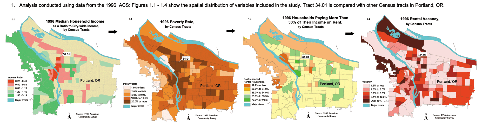
In addition, with data being collected just every 10 years, the information from the long form becomes quickly outdated, and its usefulness declines each successive year, according to Nancy Torrieri, senior program analyst, Demographic Survey Division, U.S. Census Bureau. Yet billions of dollars from public and private funds are doled out among population groups based on their social and economic profiles derived from the census. "There was a need for a system that continuously collects data throughout the year and the decade to produce measures of change over time and more current data than the decennial census long form," says Torrieri. A Continuous Stream of Accurate DataIn the 1990s, the Census Bureau began detailing a plan for implementing a continuous collection and measurement system that would produce annual and multiyear estimates of population characteristics. The program, the American Community Survey (ACS) (see sidebar), was initiated at four sites in 1996 and expanded to eight in 1997 to determine its operational feasibility, evaluate costs and procedures, and evaluate the new data. By 1999, the number of pilot sites had expanded to 31 areas that represent various combinations of demographic characteristics. Pending congressional approval for funding, in 2003 the Census Bureau plans to implement the ACS in every U.S. county and Native American and Alaska Native area based on a total annual sample of three million housing units. In full operation, ACS data will be available every year for areas and population groups of 65,000 or more beginning in 2004. For small areas and population groups of 20,000 or less, it will take five years to accumulate a large enough sample to provide estimates with accuracy similar to the decennial census. Updated information for these areas will be available starting in 2008 and every year thereafter. The ACS brings the GIS professional a source of current, accurate demographic information to use in conjunction with the Topologically Integrated Geographic Encoding and Referencing (TIGER) system data (TIGER/Line), resulting in a powerful tool for community decision making, marketing, policy analysis, and other geographic applications that rely on census data. The Census Bureau's population estimates program will improve, and because the ACS can screen for households with specific characteristics, it will help establish robust sampling frames for other surveys. Applications in Health CarePlanners and analysts in several ACS development sites are already using ACS data in GIS applications to identify and address community issues such as health care, public safety, education, economic development, needs of the elderly, child welfare, rural issues, and transportation. In Springfield, Massachusetts, health care professionals are integrating Hampden County ACS data with information from the area's two major medical centers and the health, planning, and police departments to use in modeling applications. Implemented in ArcView and S-PLUS for ArcView for GIS, the models help to identify geographic areas and population subgroups that need health care intervention, specifically in the areas of youth violence and late stage breast cancer detection. "We wanted to create a profile of communities in Springfield in need of increased breast cancer screening to aid in planning intervention programs," says Jane McCall Garb, a biostatistician and spatial epidemiologist on the GIS team at Baystate Medical Center. "Specifically, we wanted to identify parts of the City with high concentrations of advanced disease and to identify socioeconomic and demographic factors that contributed to this." Garb and her coinvestigators Amy Pasini, Jessica Schueler, Isha Mustafa, and Richard Wait first mapped the locations of late-stage breast cancer cases in ArcView to see where clustering might indicate the need for intensified intervention efforts in certain parts of the City. The spatial scan statistic would confirm any visual indication of clustering seen on the map. With ArcView they integrated ACS data on the number of women over 40 in each police sector to calculate and map rates of advanced disease for each sector. Additional population and housing data from the ACS enabled them to see if the pattern of late-stage disease matched that of any sociodemographic factors. Spatial regression enabled further exploration of these trends. While there was no significant geographic clustering, race, marital status, completion of high school, and foreign-born status were significant factors. This methodology will be useful in improving the design of health care intervention programs and resource allocation. Garb says the ACS data provides denominators for calculating disease risk and assists in creating community profiles to identify the size, location, and demographic makeup of high-risk populations. Pinpointing Housing NeedsTimely, detailed, and accurate data is indispensable for housing assessments. Case studies include
They DeliverThe ACS program promises faster delivery of data to users and will provide summarized data on CD-ROM for population and housing estimates. For faster data access and dissemination, users will be able to access ACS data on the American FactFinder Web site (factfinder.census.gov) and download microdata files, tabulated files, and all associated documentation directly into their GIS software. Future PlansTesting of the American Community Survey has been highly successful to date. In 2000, the Census Bureau conducted the Census 2000 Supplementary Survey (C2SS) as part of the program to reengineer the 2010 Census. The C2SS was an operational test conducted during Census 2000 to assess whether the Census Bureau could use an independent process to collect high-quality information similar to the census long form at the same time the decennial census operations were taking place. The C2SS used the American Community Survey form and data collection methods. Conducting the C2SS was a critical component of the testing to replace the 2010 Census long form with the American Community Survey. The Census Bureau is disseminating data collected from the C2SS through its Web site (www.census.gov/c2ss/www). Nancy Gordon, associate director for Demographic Programs, U.S. Census Bureau, reports that data users are enthusiastic about the ACS. She is optimistic about the prospects for funding the program. "We believe we can present a persuasive case to the Congress that it is in our country's best interests to redesign the census in 2010," Gordon says. "The American Community Survey is the linchpin of that redesign plan. We anticipate that the Congress will grant us the full amount so that we can redesign the census to achieve the best possible count, provide timely data for the country, and save money for the American taxpayer." For more information, contact Rick Ayers, Esri (e-mail: rayers@esri.com) or visit www.census.gov/acs/www or www.censuswatch.com. |