Winter 2002/2003
Winter 2002/2003 |
|||||||
|
|
|||||||
Aplomado Falcon Finds New Home With the Help of GIS and Imaging |
|||||
|
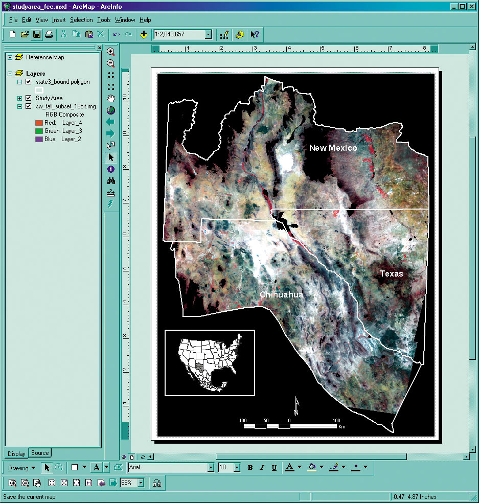
Aplomado, the Spanish word for dark gray, refers to the coloring of the top feathers on the remarkable Aplomado Falcon, which was once a common raptorial (predatory) bird in the coastal and interior grasslands of the American southwest. Known for its striking color, majestic posture, and graceful flight, the species all but disappeared from the United States during the 1950s and was listed as endangered by the U.S. Fish and Wildlife Service in 1986. Starting in the 1990s, increases in reliable falcon sightings prompted additional interest in recovery of the species in New Mexico. Recently, researchers at New Mexico State University (NMSU) employed remote sensing and GIS applications to evaluate millions of acres in the Chihuahuan Desert to identify habitat features most likely to sustain a population of the endangered birds. The Chihuahuan Desert region stretches from the Rio Grande Valley in southern New Mexico far into Mexico. It is 1,200 miles long and 800 miles wide. The final products, a documented predictive model and a map depicting habitat suitability across a large portion of the species' range, are aiding in prioritizing areas for conservation consideration and making land use decisions that benefit falcon habitat restoration.
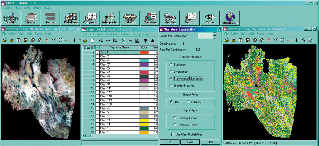
The U.S. Bureau of Land Management; the U.S. Army White Sands Missile Range; Fort Bliss Military Reservation; and T&E, Inc. (Cortaro, Arizona), funded the eight-person NMSU research team, which was charged with providing a better understanding of the Aplomado Falcon's natural history by describing falcon use areas in northern Chihuahua, Mexico. The GIS predictive modeling section was part of a five-year research endeavor that consisted of three phases. The first and second phases involved surveying the Aplomado Falcon habitat in Mexico's Chihuahuan Desert to locate and describe the physical features of the landscape where the birds exist--with the help of staff at the Universidad Autonoma de Chihuahua. The third phase involved analyzing satellite imagery as well as terrain data derived from digital elevation models of the Chihuahuan Desert spanning northern Chihuahua, southern New Mexico, and western Texas to digitally locate the features identified as indicators of possible falcon habitat. "This research should help to focus conservation on habitats that benefit this bird and promote overall integrity of grassland communities," states Bruce Thompson, professor of wildlife sciences and leader of the New Mexico Cooperative Fish and Wildlife Research Unit (NMCFWRU), the joint federal-state-university program at NMSU. Kendal Young, research project coordinator, NMSU, adds, "The presence of falcons as an indicator of an overall healthy environment makes this research even more relevant for human beings." Because this slender, long-tailed falcon (15-18 inches in length with a three-foot wingspan) with a distinctive white line located below the black cap on its head does not build its own nests, but takes over the abandoned nests of other large birds, a thriving ecosystem of other large birds and small prey is needed to sustain an Aplomado Falcon population. Analyses were conducted using Esri's ArcGIS, Leica Geosystems' ERDAS IMAGINE, and FRAGSTATS public domain software packages. "The extensive cartographic functionality of ArcGIS, as well as the versatility of the Esri format made Esri software a logical choice," states Dawn Browning, GIS/remote sensing analyst, NMSU. Use of the three components was key to the project's success because they produced the accurate results needed; ArcGIS interacted with both ERDAS IMAGINE (provided under an educational agreement) and FRAGSTATS applications; and ArcGIS was familiar to most end users of the final model, a critical factor in the project. To visually identify the land cover patterns that corresponded to those found in the Aplomado Falcon habitat, one set of imagery was collected for spring and fall seasons that produce different vegetation responses found in the Chihuahuan Desert. "The falcons require a combination of vegetation types: grasslands (for their prey base) with shrublands (where they perch and nest)," says Browning. Because of cloud cover conditions, each set of 15 LANDSAT 7 ETM+ data imagery was collected over a five-week span.
ERDAS IMAGINE software was used to import, reconcile, and analyze the two sets of data images covering the study area of 246,848 km2. After the multispectral data were imported, the digital values were converted to spectral reflectance values to describe the vegetation around the habitat. Using the histogram bias technique, the images were standardized to a single date for each season while maintaining the true shape and distribution of the data in the image. When both data sets were standardized (each roughly 20 gigabytes), the imagery was evaluated for spectrally distinct classes contained within the entire study area for both seasons. The distribution of falcon use sites among the land cover classes was examined to identify classes that corresponded with falcon presence. "Information regarding landscape structure, such as interspersion between important classes (e.g., grasslands and shrublands), was extremely helpful in examining aspects of the environment surrounding falcon use areas," says Julie Lanser, a geography graduate student involved in this part of the research. Once converted to ArcGrid, FRAGSTATS software was used on the classified images to calculate landscape metrics around falcon use sites using the thematic grids as input. This information, coupled with that of the configuration and composition of land cover classes within a larger landscape, was used in the habitat modeling process. Using ArcGIS, five predictor variables were converted to binary grids and added to create an output map representing a range of Aplomado Falcon habitat suitability. Higher values in the map represent areas where a greater number of qualifying criteria were met, and lower values represent areas where fewer criteria were met. The binary input layer and final predictive model grids were converted to images in ERDAS IMAGINE; then all files were combined into one. Accuracy assessment analyses determined that the resulting model was highly effective in predicting "places of promise" for Aplomado Falcon conservation. "We have at least 67 percent agreement between the field assessed and predictive model rankings at evaluated field sites," states Browning. Errors were largely attributed to differences in assigning like predictive values between field biologists and predictive model values. Each of 21 prospective or known falcon habitat assessment areas that were identified independent of spatial modeling contained habitat with high predictive ranking. Cartographic production was performed using the ArcMap tool within ArcGIS Desktop. The resulting predictive model and map of suitable Aplomado Falcon habitat now serves as an effective tool for identifying areas similar to falcon use areas in Chihuahua. "Using GIS software to access information about the configuration and land cover from the imagery enabled us to analyze an incredibly large area, while maintaining a comprehensive view of the entire project," comments Thompson. The NMSU research unit spearheading the Aplomado Falcon habitat suitability project is one of 39 units across 37 states that function under a U.S. Geological Survey cooperative agreement among federal and state agencies, universities, and private organizations focused on preventing the deterioration of the nation's natural resources. The research results, made public in late summer 2002, will assist government agencies in making informed decisions about the allocation of federal resources as well as environmental and development planning. For more information, contact the NMCFWRU Aplomado Falcon habitat suitability project (tel.: 505-646-6053, fax: 505-646-1281, Web: leopold.nmsu.edu/fwscoop). |