Winter 2002/2003
Winter 2002/2003 |
|||||||
|
|
|||||||
Additional ArcIMS Functionality Has Positive Impact
Cabarrus County, North Carolina, Provides More Services to Its Tax Assessor Division Using GIS |
|||||
|
By Cathy Cole, GIS Manager, Cabarrus County GIS, and Kim Wallis, M.A. Candidate, University of North Carolina-Charlotte
Cabarrus County, North Carolina, east of the foothills of the Blue Ridge Mountains, is part of the 16-county Charlotte region, made up of both North and South Carolina counties. The region is home to more than 1.8 million people and includes the cities of Kannapolis, Harrisburg, and Concord. With a landscape of rolling hills and largely a rural county, Cabarrus County's close proximity to the burgeoning city of Charlotte, North Carolina, has enabled its cities along highway and interstate corridors to grow at an increasingly fast pace. The county is steeped in history, from the first gold discovery at Reed Gold Mine in 1799 to the famous Cannon Mills, which was one of the first plants to process and sell cotton in the south. The "model mill village," which provided housing, churches, schools, and a hospital to the Cannon Mill employees became the city of Kannapolis. Most notoriously, Cabarrus County is home to many racing fans and houses Lowe's Motor Speedway. The speedway is home to NASCAR, IROC, IRL, World Karting, and Legends car racing. With over six million people living within a 100-mile radius of Charlotte, the area stands as the nation's fifth largest urban region. Cabarrus County GISTo facilitate the planning process for the rapid development and accompanying population growth in the county, the GIS Division of the Cabarrus County Information Technology Department plays an important role by maintaining accurate, current data and providing efficient and sophisticated ways to transmit that data. In addition to providing customized maps and data to the general public, Cabarrus County GIS has been providing custom GIS applications for various divisions within the county government. These include applications to output customized property maps and update centerline and address files. The GIS Division has also recently updated its Internet site at www.co.cabarrus.nc.us to pull zoning, parcel, flood zone, voter district, parks and recreation, and route mapper data from ArcSDE data storage. ArcIMS Tax Application
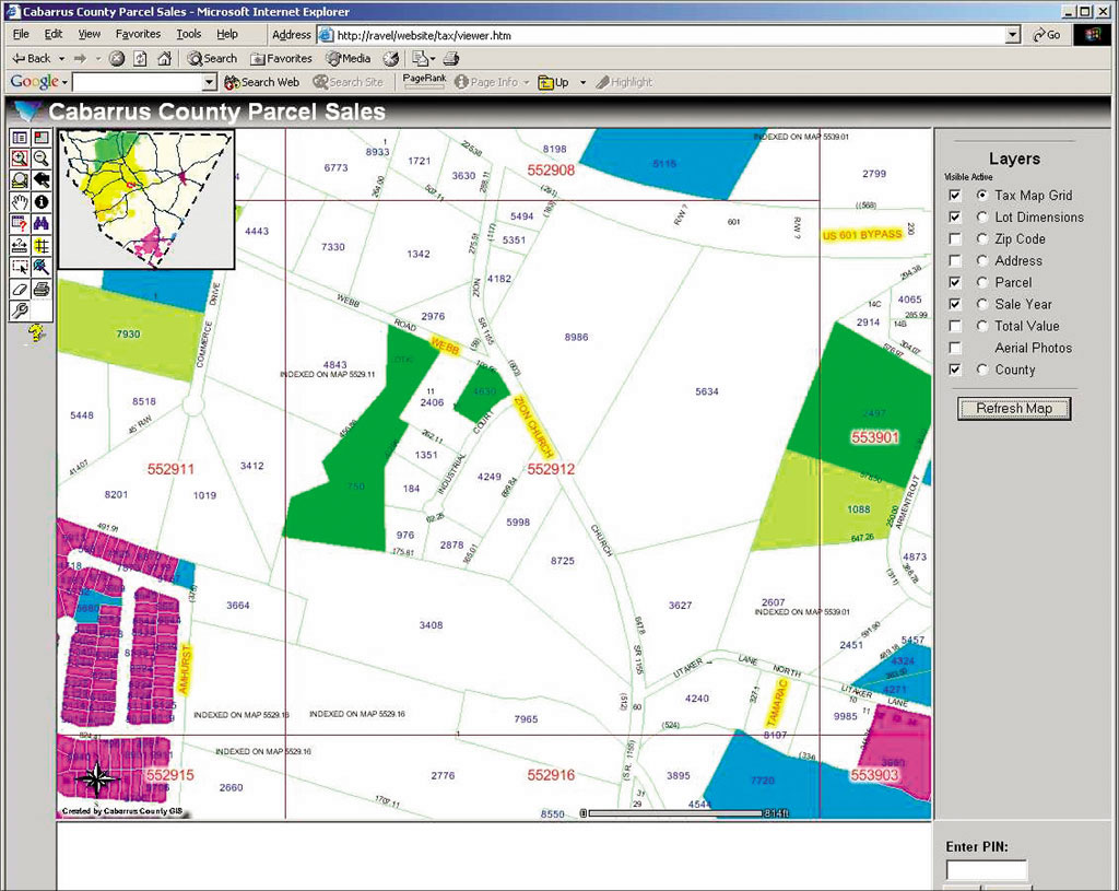
Most recently, Cabarrus County GIS has added to interoffice efficiency by creating an application called "Cabarrus County Parcel Sales" for the Tax Reevaluation Department. The motivation for this application was to create an application that would (1) be accessed by the Intranet, (2) provide the tools needed by the assessors to analyze parcel sales and sales prices in the county in a more visual manner, and (3) help staff members become more self sufficient. After viewing several different demonstrations by various software vendors and obtaining quotes, GIS Analyst Chris Thomas wanted to utilize his Esri ArcIMS and ArcObjects training. The Cabarrus County Parcel Sales application, which he developed, uses much of the out-of-the-box functionality of the HTML Viewer application that comes with ArcIMS 3.1. In addition, he customized several components using HTML, JavaScript, and several scripts posted on Esri's ArcScripts Web site. With University of North Carolina-Charlotte student Aaron Dorsey assisting, some of the customizations he added include
Uses and ImpactThe application accesses ArcSDE geodatabase data and is available to be used for identification, querying, and analysis. The Tax Reevaluation Department can view properties that are in exempt status, measure acreage for land use and back billing, view aerials of properties to determine how they are actually being used for compliance reviews, and settle appeals of property value that otherwise would have taken much longer to investigate. For more information, contact Cabarrus County GIS, P.O. Box 707, Concord, North Carolina 28026 (tel.: 704-920-2331, fax: 704-920-2146, Web: www.co.cabarrus.nc.us). |