Winter 2002/2003
Winter 2002/2003 |
|||||||
|
|
|||||||
Improving CAD-GIS Interoperability |
|||||
|
By Dr. David J. Maguire, Director of Products, Esri CAD and GIS software systems have evolved largely independently but in parallel over the past 30 years. CAD systems have focused on automating the drafting process with electronic drawings. As such, these systems place high emphasis on 2D graphics, sketching, and coordinate geometry tools. The graphic is the database, and a drawing file is the persistence container, i.e., where the graphics are stored. Typical applications include project engineering and site design, facilities management, and construction drafting. CAD drawings are usually large in cartographic scale (e.g., 1:500-1:5,000). In contrast, GIS software systems have more formal data models with rule-based editing and topology as well as an emphasis on spatial analysis and high-end cartography. GIS data is stored and managed in databases. Typical GIS applications include mapping, site suitability analysis, and network analysis. The key points here are that at their core CAD and GIS are different and complementary; both are valuable technologies. Any attempt to build a single integrated CAD-GIS system is fraught with pitfalls. CAD systems pretending to be GIS suffer from poor handling of object attributes, limited and slow database links, and rudimentary spatial analysis and cartography capabilities. They offer limited capabilities for data integration and sharing. GIS trying to be CAD systems are often accused of being overly complex, being too slow at screen refresh, and having limited sketching and drafting capabilities. Resolution of this dilemma lies in taking a best of breed approach and building better linkages between CAD and GIS software packages. This is exactly the kind of agenda that Esri has been following over the last 10 years. Approaches to CAD-GIS Integration
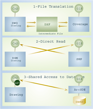
There are three technologies used to integrate CAD and GIS software systems--file translation, direct read, and shared access to a database. File translation involves conversion of data from one file format to another (e.g., DXF to SHP or SHP to DGN). Because of the differences in CAD and GIS data models and file formats, users need to specify the syntactic and semantic mapping. An example of file translation is the DWG-DXF-Coverage translator in ArcInfo Workstation. Direct read is conceptually similar to file translation except that data is read and converted on the fly into memory. There is no intermediate format, just an in-memory representation in the GIS. For example, ArcView can read MicroStation DGN files directly so the CAD data can be visualized, queried, and printed in the same map as other GIS data. An alternative to data conversion is shared access to a database. Technically, one system embeds an application programming interface (API) that allows access to data on the fly. Esri's CAD Client extension to ArcSDE allows MicroStation or AutoCAD users to store and retrieve CAD elements and GIS features in a DBMS. The ArcSDE access API is embedded inside the CAD system. The API shows up as tools in the CAD user interface. CAD-GIS Integration InitiativeToday there are a few hundred thousand Esri users who integrate CAD data into their GIS work flows using standard out-of-the-box solutions that implement the three approaches discussed above. Not content with the status quo, Esri is launching a new initiative to significantly enhance CAD-GIS integration. This initiative has the following elements:
Create Intelligent CAD Translator--An important geoprocessing tool that will be released in ArcGIS 9 is an advanced, bidirectional CAD-GIS translator. This translator will move data seamlessly from a CAD system to a GIS and back again. Rules governing the translation process are created in the context of a geoprocessing process model, script, or tool. Not only will this translator support all key data types and relationships, but it will also allow users to modify data using any geoprocessing tool. For example, it may be appropriate to clean geometry using topology tools, clip unwanted data, or project the drawing into world coordinates. Support Latest CAD Formats--ArcGIS 9 will upgrade the existing technologies to support the latest CAD formats such as Autodesk DWG/DXF 2002 and Bentley DGN V8 (see "Esri and Bentley Systems"). Some of the more advanced CAD element types will also be accessible (e.g., attribute links, Xdata, and annotation). Enhance CAD-Like Editing in ArcGIS--At ArcGIS 8.3 several new CAD editing tools (Fillet, Proportion, Inverse, Traverse, etc.) were added to the object editor. More tools will be added in future releases. Create Engineering Applications--Esri, in collaboration with our network of Business Partners, is building engineering applications on top of the ArcGIS applications. Some of the first applications are already available, and others will follow in 2003. Key application areas include facilities management, wastewater and storm water, electric, gas, roads, site design, and cadastral/land records. 3D Objects/Models--As part of a long-term process of building a true 3D GIS, Esri is adding support for 3D CAD objects at ArcGIS 9. The same translation and direct technologies discussed above will support both 2D and 3D objects. 3D objects will be stored in the geodatabase and rendered and queried in ArcScene. ConclusionBoth GIS and CAD are important and different technologies. Recognizing their complementary nature, Esri is working on improving interoperability at the data and tool levels. This is a long-term goal, with significant progress being shown at the ArcGIS 9 release. In this way we hope that we can support our users better in their everyday work. For more information, contact Don Kuehne, CAD specialist, Esri (e-mail: dkuehne@esri.com). See sidebar, "Esri and Bentley Systems." |