Winter 2002/2003
Winter 2002/2003 |
|||||||
|
|
|||||||
A Design Guide for the U.S. Government's Framework Layers
Introducing the 1:24,000 Scale U.S. Base Map Data Model |
|||
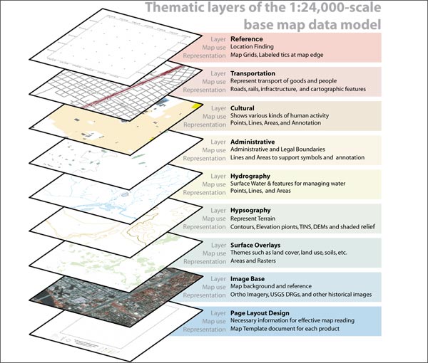
The portions of the topographic base map data model on adjoining pages 26 and 27 [PDF-3.12 MB] illustrate the best practices and methods for representing the U.S. basemap layers at 1:24,000 scale. The full model includes all themes for producing high-quality map sheets and complete specifications for three map styles based on contour-based hypsography, shaded relief, and an orthoimage base. Traditional map series can be produced automatically as well as maps centered on any location. The data content in this model is multipurpose and shares designs with other GIS data model efforts including hydrography, transportation, elevation, and orthoimagery. This design was developed in collaboration with members of the Texas Natural Resource Information System (TNRIS) Strategic Mapping Program (known as StratMap) and the Texas Department of Transportation county highway maps for the Texas pilot project of The National Map--the U.S. Geological Survey initiative to maintain base data through the collaborative efforts of many state, local, and federal agencies. Additional design goals address requirements such as
The complete specification, including a sample database, is at support.esri.com/datamodels. Why Is a Data Model for The National Map Important?Ideally, the data layers in a GIS, such as for hydrography and transportation, should be usable for both traditional GIS applications as well as for cartography. A major challenge for many GIS users is the generation of high-quality basemaps on which GIS analyses and results are presented. Equally challenging for cartographers is the application of multipurpose GIS layers for high-end cartography. Most GIS users can readily design data models to meet their GIS needs. However, ensuring these same layers contain all of the necessary information to support advanced cartography is a challenge. The common data model represents a practical implementation that leverages today's best GIS technology. Wide adoption of the data models by state GIS organizations is expected. Ongoing WorkRecent work has focused on the specification of automation and conversion work flows to add data into the new model, quality validation of the content in each layer, and automated tools for map production. Esri's Production Line Tool Set (PLTS) now supports both the data automation work flows as well as the cartographic production cycles. |